![](/images/other/stat-length.png)
![Trail Cycle Pont-de-Barret - Le col de la Chaudière - Photo](https://media.geolcdn.com/t/1900/400/ext.pjpeg?maxdim=2&url=https%3A%2F%2Fservices.sitytrail.com%2FGeolivesWS%2FDownloadMedia.ashx%3FTrailID%3D105514%26Media%3D9265_6.jpg)
Le col de la Chaudière
tracegps
User
![Length](/images/other/stat-length.png)
Length
75 km
![Max alt](https://static1.geolcdn.com/siteimages/upload/files/1508320355ic_sort_altitude_max_24dp.png)
Max alt
1055 m
![Uphill gradient](https://static1.geolcdn.com/siteimages/upload/files/1508320355ic_sort_den_pos_24dp.png)
Uphill gradient
1616 m
![Km-Effort](/images/other/stat-length.png)
Km-Effort
96 km
![Min alt](https://static1.geolcdn.com/siteimages/upload/files/1508320355ic_sort_altitude_min_24dp.png)
Min alt
204 m
![Downhill gradient](https://static1.geolcdn.com/siteimages/upload/files/1508320355ic_sort_den_neg_24dp.png)
Downhill gradient
1617 m
![Boucle](https://static1.geolcdn.com/siteimages/upload/files/16400158638029165_repeat_loop_refresh_sync_direction_icon.png)
Boucle
Yes
Creation date :
2014-12-10 00:00:00.0
Updated on :
2014-12-10 00:00:00.0
![Cycle](https://static1.geolcdn.com/sitytour/trail-icons/200.png)
5h00
Difficulty : Difficult
![Scan this QR Code to open this trail in the SityTrail application](https://capi.geolives.com/qq0zvz2zws4bq2lad0pu/sitytour/trails/105514/qr.png?size=200)
FREE GPS app for hiking
About
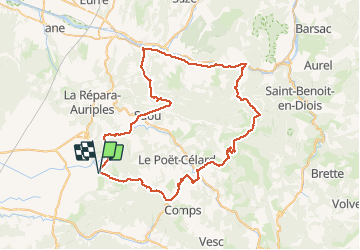
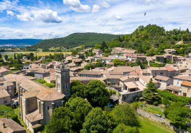
Trail Cycle of 75 km to be discovered at Auvergne-Rhône-Alpes, Drôme, Pont-de-Barret. This trail is proposed by tracegps.
Description
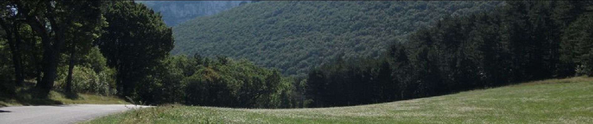
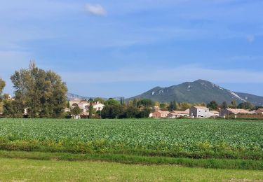
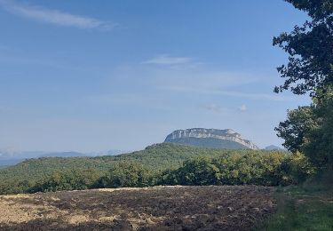
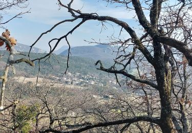
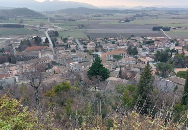
Un très beau parcours assez difficile car si le col de la Chaudière n'est qu'à un peu plus de 1000 m d'altitude, il y a plus de 1600 m de montée (et de descente). Les paysages sont très beaux en particulier le Pas de Lauzun lors de la montée vers Saou.
Positioning
Country:
France
Region :
Auvergne-Rhône-Alpes
Department/Province :
Drôme
Municipality :
Pont-de-Barret
Location:
Unknown
Start:(Dec)
Start:(UTM)
658588 ; 4939206 (31T) N.
Comments
Trails nearby
![Trail Walking Charols - 2022-10-01_18h01m37_13052196 - Photo](https://media.geolcdn.com/t/375/260/44333c54-0203-4720-b217-7a484d4324d6.jpg&format=jpg&maxdim=2)
![Walking Walking](https://static1.geolcdn.com/sitytour/trail-icons/101.png)
2022-10-01_18h01m37_13052196
Walking
Medium
(2)
Charols,
Auvergne-Rhône-Alpes,
Drôme,
France
![](/images/other/stat-length.png)
10.7 km | 13.6 km-effort
3h 2min
![](https://static1.geolcdn.com/siteimages/upload/files/16400158638029165_repeat_loop_refresh_sync_direction_icon.png)
Yes
![Trail Walking Puy-Saint-Martin - 2022-09-27_14h04m59_10644793 - Photo](https://media.geolcdn.com/t/375/260/6480930c-30c1-44b7-a230-4fcbebdc50ce.jpg&format=jpg&maxdim=2)
![Walking Walking](https://static1.geolcdn.com/sitytour/trail-icons/101.png)
2022-09-27_14h04m59_10644793
Walking
Medium
(3)
Puy-Saint-Martin,
Auvergne-Rhône-Alpes,
Drôme,
France
![](/images/other/stat-length.png)
7.1 km | 10.5 km-effort
2h 22min
![](https://static1.geolcdn.com/siteimages/upload/files/16400158638029165_repeat_loop_refresh_sync_direction_icon.png)
Yes
![Trail Walking Pont-de-Barret - Pont-de-Barret 7km5 - Photo](https://media.geolcdn.com/t/375/260/bd4539ba-b505-451b-88b8-8a669ff8e607.jpg&format=jpg&maxdim=2)
![Walking Walking](https://static1.geolcdn.com/sitytour/trail-icons/101.png)
Pont-de-Barret 7km5
Walking
Difficult
(1)
Pont-de-Barret,
Auvergne-Rhône-Alpes,
Drôme,
France
![](/images/other/stat-length.png)
7.5 km | 12.5 km-effort
2h 50min
![](https://static1.geolcdn.com/siteimages/upload/files/16400158638029165_repeat_loop_refresh_sync_direction_icon.png)
Yes
![Trail Walking Puy-Saint-Martin - 2022-10-01_17h58m38_13274577 - Photo](https://media.geolcdn.com/t/375/260/248bb3c4-3f75-4f03-8f85-e68449b4e6e0.jpg&format=jpg&maxdim=2)
![Walking Walking](https://static1.geolcdn.com/sitytour/trail-icons/101.png)
2022-10-01_17h58m38_13274577
Walking
Easy
(1)
Puy-Saint-Martin,
Auvergne-Rhône-Alpes,
Drôme,
France
![](/images/other/stat-length.png)
5.1 km | 5.7 km-effort
1h 18min
![](https://static1.geolcdn.com/siteimages/upload/files/16400158638029165_repeat_loop_refresh_sync_direction_icon.png)
Yes
![Trail Walking Puy-Saint-Martin - Puy st Martin les Ours 8km - Photo](https://media.geolcdn.com/t/375/260/bf268e09-61bd-4eea-a081-31676e501b35.jpg&format=jpg&maxdim=2)
![Walking Walking](https://static1.geolcdn.com/sitytour/trail-icons/101.png)
Puy st Martin les Ours 8km
Walking
Easy
(1)
Puy-Saint-Martin,
Auvergne-Rhône-Alpes,
Drôme,
France
![](/images/other/stat-length.png)
7.7 km | 11.6 km-effort
3h 4min
![](https://static1.geolcdn.com/siteimages/upload/files/16400158638029165_repeat_loop_refresh_sync_direction_icon.png)
Yes
![Trail Walking Puy-Saint-Martin - Puy St Martin Chevriere-Saudon 16 km - Photo](https://media.geolcdn.com/t/375/260/69bb143d-562e-45de-9da3-14e8db74501d.jpg&format=jpg&maxdim=2)
![Walking Walking](https://static1.geolcdn.com/sitytour/trail-icons/101.png)
Puy St Martin Chevriere-Saudon 16 km
Walking
Medium
(1)
Puy-Saint-Martin,
Auvergne-Rhône-Alpes,
Drôme,
France
![](/images/other/stat-length.png)
16 km | 22 km-effort
6h 35min
![](https://static1.geolcdn.com/siteimages/upload/files/16400158638029165_repeat_loop_refresh_sync_direction_icon.png)
Yes
![Trail On foot Eyzahut - SityTrail - Boucle 1 - Photo](https://media.geolcdn.com/t/375/260/18dbfece-5a68-4dfb-9f06-5bb6196c6685.jpg&format=jpg&maxdim=2)
![On foot On foot](https://static1.geolcdn.com/sitytour/trail-icons/100.png)
SityTrail - Boucle 1
On foot
Very difficult
(2)
Eyzahut,
Auvergne-Rhône-Alpes,
Drôme,
France
![](/images/other/stat-length.png)
17.3 km | 31 km-effort
6h 0min
![](https://static1.geolcdn.com/siteimages/upload/files/16400158638029165_repeat_loop_refresh_sync_direction_icon.png)
Yes
![Trail Walking Soyans - Soyans- Rochecolombe 15 km - Photo](https://media.geolcdn.com/t/375/260/72e33805-cd1b-4df3-9acd-288f3ea7428d.jpg&format=jpg&maxdim=2)
![Walking Walking](https://static1.geolcdn.com/sitytour/trail-icons/101.png)
Soyans- Rochecolombe 15 km
Walking
Medium
(1)
Soyans,
Auvergne-Rhône-Alpes,
Drôme,
France
![](/images/other/stat-length.png)
14.6 km | 19.7 km-effort
5h 42min
![](https://static1.geolcdn.com/siteimages/upload/files/16400158638029165_repeat_loop_refresh_sync_direction_icon.png)
Yes
![Trail Walking Soyans - 26 la repara - Photo](https://media.geolcdn.com/t/375/260/b5326b1e-c626-429d-9f7a-276ac352b759.jpg&format=jpg&maxdim=2)
![Walking Walking](https://static1.geolcdn.com/sitytour/trail-icons/101.png)
26 la repara
Walking
Medium
Soyans,
Auvergne-Rhône-Alpes,
Drôme,
France
![](/images/other/stat-length.png)
13.6 km | 20 km-effort
5h 12min
![](https://static1.geolcdn.com/siteimages/upload/files/16400158638029165_repeat_loop_refresh_sync_direction_icon.png)
Yes
Too