![](/images/other/stat-length.png)
![Trail Walking Saint-Sauveur-sur-École - Saint-Sauveur - Photo](https://media.geolcdn.com/t/1900/400/0a58cec2-9af6-4f75-93a7-4b29986f8a07.jpg&format=pjpeg&maxdim=2)
Saint-Sauveur
dmatignon
User
![Length](/images/other/stat-length.png)
Length
11.2 km
![Max alt](https://static1.geolcdn.com/siteimages/upload/files/1508320355ic_sort_altitude_max_24dp.png)
Max alt
88 m
![Uphill gradient](https://static1.geolcdn.com/siteimages/upload/files/1508320355ic_sort_den_pos_24dp.png)
Uphill gradient
140 m
![Km-Effort](/images/other/stat-length.png)
Km-Effort
13.1 km
![Min alt](https://static1.geolcdn.com/siteimages/upload/files/1508320355ic_sort_altitude_min_24dp.png)
Min alt
44 m
![Downhill gradient](https://static1.geolcdn.com/siteimages/upload/files/1508320355ic_sort_den_neg_24dp.png)
Downhill gradient
140 m
![Boucle](https://static1.geolcdn.com/siteimages/upload/files/16400158638029165_repeat_loop_refresh_sync_direction_icon.png)
Boucle
Yes
Creation date :
2019-01-15 17:33:44.357
Updated on :
2019-06-11 12:05:49.201
![Walking](https://static1.geolcdn.com/sitytour/trail-icons/101.png)
2h53
Difficulty : Easy
![Scan this QR Code to open this trail in the SityTrail application](https://capi.geolives.com/qq0zvz2zws4bq2lad0pu/sitytour/trails/1054908/qr.png?size=200)
FREE GPS app for hiking
About
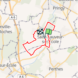
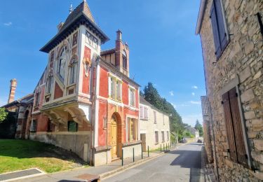
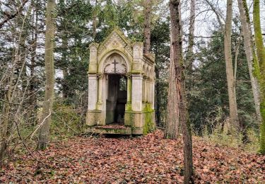
Trail Walking of 11.2 km to be discovered at Ile-de-France, Seine-et-Marne, Saint-Sauveur-sur-École. This trail is proposed by dmatignon.
Description
Petite randonnée à travers champs et bois.
Au passage découvertes de quelques lavoirs, moulins, et belles propriétés.
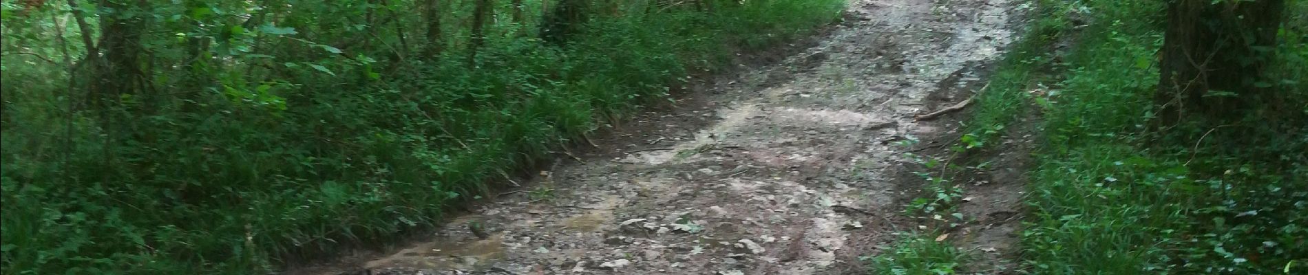
Les chemins peuvent être très boueux après la pluie.
Positioning
Country:
France
Region :
Ile-de-France
Department/Province :
Seine-et-Marne
Municipality :
Saint-Sauveur-sur-École
Location:
Unknown
Start:(Dec)
Start:(UTM)
466215 ; 5371823 (31U) N.
Comments
Trails nearby
![Trail On foot Saint-Germain-sur-École - Boucle Soisy Sur Ecole - Photo](https://media.geolcdn.com/t/375/260/191519f5-31af-4b92-abf3-6dc57900b32f.jpg&format=jpg&maxdim=2)
![On foot On foot](https://static1.geolcdn.com/sitytour/trail-icons/100.png)
Boucle Soisy Sur Ecole
On foot
Medium
(1)
Saint-Germain-sur-École,
Ile-de-France,
Seine-et-Marne,
France
![](/images/other/stat-length.png)
21 km | 25 km-effort
5h 39min
![](https://static1.geolcdn.com/siteimages/upload/files/16400158638029165_repeat_loop_refresh_sync_direction_icon.png)
Yes
![Trail Walking Saint-Fargeau-Ponthierry - Boucle 20 km Saint Fargeau - Photo](https://media.geolcdn.com/t/375/260/1121cafc-c79f-4e4a-a841-485665e96120.jpg&format=jpg&maxdim=2)
![Walking Walking](https://static1.geolcdn.com/sitytour/trail-icons/101.png)
Boucle 20 km Saint Fargeau
Walking
Easy
Saint-Fargeau-Ponthierry,
Ile-de-France,
Seine-et-Marne,
France
![](/images/other/stat-length.png)
21 km | 23 km-effort
4h 34min
![](https://static1.geolcdn.com/siteimages/upload/files/16400158638029165_repeat_loop_refresh_sync_direction_icon.png)
Yes
![Trail Walking Saint-Germain-sur-École - Boucle soisy version definitif - Photo](https://media.geolcdn.com/t/375/260/393daa89-85e9-457d-aec1-026a61438d59.jpg&format=jpg&maxdim=2)
![Walking Walking](https://static1.geolcdn.com/sitytour/trail-icons/101.png)
Boucle soisy version definitif
Walking
Easy
Saint-Germain-sur-École,
Ile-de-France,
Seine-et-Marne,
France
![](/images/other/stat-length.png)
22 km | 26 km-effort
4h 53min
![](https://static1.geolcdn.com/siteimages/upload/files/16400158638029165_repeat_loop_refresh_sync_direction_icon.png)
Yes
![Trail Walking Boissise-la-Bertrand - Boucle Boissise la BERTRAND 30 km - Photo](https://media.geolcdn.com/t/375/260/6730328b-3210-43a6-9f84-f1c044935aa5.jpg&format=jpg&maxdim=2)
![Walking Walking](https://static1.geolcdn.com/sitytour/trail-icons/101.png)
Boucle Boissise la BERTRAND 30 km
Walking
Very difficult
Boissise-la-Bertrand,
Ile-de-France,
Seine-et-Marne,
France
![](/images/other/stat-length.png)
32 km | 36 km-effort
6h 36min
![](https://static1.geolcdn.com/siteimages/upload/files/16400158638029165_repeat_loop_refresh_sync_direction_icon.png)
Yes
![Trail Walking Saint-Germain-sur-École - Autour de Soisy sur Ecole - Boucle 30 km - Photo](https://media.geolcdn.com/t/375/260/42a45b0a-7dbc-4142-a18c-2c21a7c16f7f.jpg&format=jpg&maxdim=2)
![Walking Walking](https://static1.geolcdn.com/sitytour/trail-icons/101.png)
Autour de Soisy sur Ecole - Boucle 30 km
Walking
Medium
Saint-Germain-sur-École,
Ile-de-France,
Seine-et-Marne,
France
![](/images/other/stat-length.png)
30 km | 36 km-effort
6h 3min
![](https://static1.geolcdn.com/siteimages/upload/files/16400158638029165_repeat_loop_refresh_sync_direction_icon.png)
Yes
![Trail Walking Saint-Sauveur-sur-École - Autour de St Sauveur l'Ecole - Photo](https://media.geolcdn.com/t/375/260/60d05cfc-695b-4981-a344-8a4aca4564fc.jpg&format=jpg&maxdim=2)
![Walking Walking](https://static1.geolcdn.com/sitytour/trail-icons/101.png)
Autour de St Sauveur l'Ecole
Walking
Very easy
Saint-Sauveur-sur-École,
Ile-de-France,
Seine-et-Marne,
France
![](/images/other/stat-length.png)
23 km | 26 km-effort
5h 13min
![](https://static1.geolcdn.com/siteimages/upload/files/16400158638029165_repeat_loop_refresh_sync_direction_icon.png)
Yes
![Trail Walking Boissise-la-Bertrand - vives eaux 2019 - Photo](https://media.geolcdn.com/t/375/260/ext.jpg?maxdim=2&url=https%3A%2F%2Fstatic1.geolcdn.com%2Fsiteimages%2Fupload%2Ffiles%2F1553511878bg_sport_marche.png)
![Walking Walking](https://static1.geolcdn.com/sitytour/trail-icons/101.png)
vives eaux 2019
Walking
Very easy
(1)
Boissise-la-Bertrand,
Ile-de-France,
Seine-et-Marne,
France
![](/images/other/stat-length.png)
11.3 km | 12.9 km-effort
2h 45min
![](https://static1.geolcdn.com/siteimages/upload/files/16400158638029165_repeat_loop_refresh_sync_direction_icon.png)
Yes
![Trail Walking Champcueil - Grands Avaux - Tertre blanc (Nainville) - fait - Photo](https://media.geolcdn.com/t/375/260/ext.jpg?maxdim=2&url=https%3A%2F%2Fstatic1.geolcdn.com%2Fsiteimages%2Fupload%2Ffiles%2F1553511878bg_sport_marche.png)
![Walking Walking](https://static1.geolcdn.com/sitytour/trail-icons/101.png)
Grands Avaux - Tertre blanc (Nainville) - fait
Walking
Easy
(1)
Champcueil,
Ile-de-France,
Essonne,
France
![](/images/other/stat-length.png)
17.7 km | 22 km-effort
4h 51min
![](https://static1.geolcdn.com/siteimages/upload/files/16400158638029165_repeat_loop_refresh_sync_direction_icon.png)
Yes
![Trail Walking Soisy-sur-École - Soisy-sur-Ecole - Tertres - Photo](https://media.geolcdn.com/t/375/260/f1ae2235-ac3a-4274-b705-36c8bd8b6282.jpg&format=jpg&maxdim=2)
![Walking Walking](https://static1.geolcdn.com/sitytour/trail-icons/101.png)
Soisy-sur-Ecole - Tertres
Walking
Medium
Soisy-sur-École,
Ile-de-France,
Essonne,
France
![](/images/other/stat-length.png)
9.9 km | 11.5 km-effort
2h 36min
![](https://static1.geolcdn.com/siteimages/upload/files/16400158638029165_repeat_loop_refresh_sync_direction_icon.png)
Yes