![](/images/other/stat-length.png)
![Trail Walking Valuéjols - Le bois des Fraux - Lescure - Photo](https://media.geolcdn.com/t/1900/400/ext.pjpeg?maxdim=2&url=https%3A%2F%2Fservices.sitytrail.com%2FGeolivesWS%2FDownloadMedia.ashx%3FTrailID%3D105472%26Media%3D9213_2.jpg)
Le bois des Fraux - Lescure
tracegps
User
![Length](/images/other/stat-length.png)
Length
8.2 km
![Max alt](https://static1.geolcdn.com/siteimages/upload/files/1508320355ic_sort_altitude_max_24dp.png)
Max alt
1306 m
![Uphill gradient](https://static1.geolcdn.com/siteimages/upload/files/1508320355ic_sort_den_pos_24dp.png)
Uphill gradient
136 m
![Km-Effort](/images/other/stat-length.png)
Km-Effort
9.9 km
![Min alt](https://static1.geolcdn.com/siteimages/upload/files/1508320355ic_sort_altitude_min_24dp.png)
Min alt
1172 m
![Downhill gradient](https://static1.geolcdn.com/siteimages/upload/files/1508320355ic_sort_den_neg_24dp.png)
Downhill gradient
131 m
![Boucle](https://static1.geolcdn.com/siteimages/upload/files/16400158638029165_repeat_loop_refresh_sync_direction_icon.png)
Boucle
Yes
Creation date :
2014-12-10 00:00:00.0
Updated on :
2014-12-10 00:00:00.0
![Walking](https://static1.geolcdn.com/sitytour/trail-icons/101.png)
2h30
Difficulty : Medium
![Scan this QR Code to open this trail in the SityTrail application](https://capi.geolives.com/qq0zvz2zws4bq2lad0pu/sitytour/trails/105472/qr.png?size=200)
FREE GPS app for hiking
About
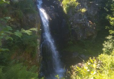
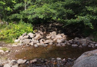
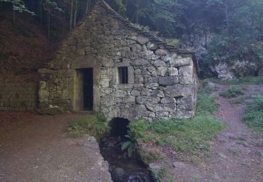
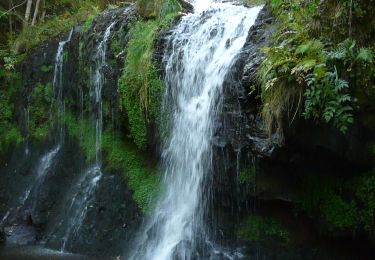
Trail Walking of 8.2 km to be discovered at Auvergne-Rhône-Alpes, Cantal, Valuéjols. This trail is proposed by tracegps.
Description
Un parcours sans problème à travers montagnes et bois sur des chemins empierrés et herbeux. Pas de soucis avec les bêtes placées dans les estives bien fermées. Une belle balade à faire en famille.
Positioning
Country:
France
Region :
Auvergne-Rhône-Alpes
Department/Province :
Cantal
Municipality :
Valuéjols
Location:
Unknown
Start:(Dec)
Start:(UTM)
490923 ; 4988913 (31T) N.
Comments
Trails nearby
![Trail Walking Albepierre-Bredons - Cantal - Albepierre - les Cascades - 9.6km 330m 3h25 - 2019 06 23 - Photo](https://media.geolcdn.com/t/375/260/7c343e5b-9b79-4737-bf33-8f8bb008b3a2.jpg&format=jpg&maxdim=2)
![Walking Walking](https://static1.geolcdn.com/sitytour/trail-icons/101.png)
Cantal - Albepierre - les Cascades - 9.6km 330m 3h25 - 2019 06 23
Walking
Easy
(1)
Albepierre-Bredons,
Auvergne-Rhône-Alpes,
Cantal,
France
![](/images/other/stat-length.png)
9.6 km | 14.1 km-effort
3h 26min
![](https://static1.geolcdn.com/siteimages/upload/files/16400158638029165_repeat_loop_refresh_sync_direction_icon.png)
Yes
![Trail Road bike Albepierre-Bredons - cascades de Veyrines et lac du pêcher - Photo](https://media.geolcdn.com/t/375/260/51bbe222-68fd-40c8-b03d-d522f834567b.jpg&format=jpg&maxdim=2)
![Road bike Road bike](https://static1.geolcdn.com/sitytour/trail-icons/201.png)
cascades de Veyrines et lac du pêcher
Road bike
Medium
Albepierre-Bredons,
Auvergne-Rhône-Alpes,
Cantal,
France
![](/images/other/stat-length.png)
73 km | 90 km-effort
4h 12min
![](https://static1.geolcdn.com/siteimages/upload/files/16400158638029165_repeat_loop_refresh_sync_direction_icon.png)
Yes
![Trail Road bike Albepierre-Bredons - Sanissage 5 cascades - Photo](https://media.geolcdn.com/t/375/260/85ecf86a-b278-4ee6-890b-5b284e817c7d.jpg&format=jpg&maxdim=2)
![Road bike Road bike](https://static1.geolcdn.com/sitytour/trail-icons/201.png)
Sanissage 5 cascades
Road bike
Medium
Albepierre-Bredons,
Auvergne-Rhône-Alpes,
Cantal,
France
![](/images/other/stat-length.png)
19.3 km | 28 km-effort
1h 12min
![](https://static1.geolcdn.com/siteimages/upload/files/16400158638029165_repeat_loop_refresh_sync_direction_icon.png)
No
![Trail Road bike Albepierre-Bredons - Le puy Mary par St Jacques des blats retour Dienne - Photo](https://media.geolcdn.com/t/375/260/27e4b2a9-b34d-4064-9ff2-6d8b9b60bab0.jpg&format=jpg&maxdim=2)
![Road bike Road bike](https://static1.geolcdn.com/sitytour/trail-icons/201.png)
Le puy Mary par St Jacques des blats retour Dienne
Road bike
Difficult
Albepierre-Bredons,
Auvergne-Rhône-Alpes,
Cantal,
France
![](/images/other/stat-length.png)
84 km | 115 km-effort
4h 7min
![](https://static1.geolcdn.com/siteimages/upload/files/16400158638029165_repeat_loop_refresh_sync_direction_icon.png)
Yes
![Trail Trail Albepierre-Bredons - Une partie des crêtes vers le Plomb du Cantal - Photo](https://media.geolcdn.com/t/375/260/721772bb-976e-40f4-94dd-71ce0a6e8753.jpg&format=jpg&maxdim=2)
![Trail Trail](https://static1.geolcdn.com/sitytour/trail-icons/104.png)
Une partie des crêtes vers le Plomb du Cantal
Trail
Medium
Albepierre-Bredons,
Auvergne-Rhône-Alpes,
Cantal,
France
![](/images/other/stat-length.png)
26 km | 42 km-effort
4h 34min
![](https://static1.geolcdn.com/siteimages/upload/files/16400158638029165_repeat_loop_refresh_sync_direction_icon.png)
Yes
![Trail Trail Albepierre-Bredons - Bredon - Photo](https://media.geolcdn.com/t/375/260/1782e2b3-d41a-4e0a-ab8e-fea1a86c2333.jpg&format=jpg&maxdim=2)
![Trail Trail](https://static1.geolcdn.com/sitytour/trail-icons/104.png)
Bredon
Trail
Medium
Albepierre-Bredons,
Auvergne-Rhône-Alpes,
Cantal,
France
![](/images/other/stat-length.png)
20 km | 28 km-effort
2h 35min
![](https://static1.geolcdn.com/siteimages/upload/files/16400158638029165_repeat_loop_refresh_sync_direction_icon.png)
Yes
![Trail Running Albepierre-Bredons - Le Plomb du Cantal - Photo](https://media.geolcdn.com/t/375/260/afbcbbd5-0a8b-4983-89d3-88ba1a5076f2.jpg&format=jpg&maxdim=2)
![Running Running](https://static1.geolcdn.com/sitytour/trail-icons/103.png)
Le Plomb du Cantal
Running
Medium
Albepierre-Bredons,
Auvergne-Rhône-Alpes,
Cantal,
France
![](/images/other/stat-length.png)
8.3 km | 16.3 km-effort
1h 24min
![](https://static1.geolcdn.com/siteimages/upload/files/16400158638029165_repeat_loop_refresh_sync_direction_icon.png)
No
![Trail Hybrid bike Albepierre-Bredons - Chambeuil - Photo](https://media.geolcdn.com/t/375/260/d192094d-27ab-4a7b-a974-4a31abcc49f1.jpg&format=jpg&maxdim=2)
![Hybrid bike Hybrid bike](https://static1.geolcdn.com/sitytour/trail-icons/203.png)
Chambeuil
Hybrid bike
Medium
Albepierre-Bredons,
Auvergne-Rhône-Alpes,
Cantal,
France
![](/images/other/stat-length.png)
23 km | 36 km-effort
2h 7min
![](https://static1.geolcdn.com/siteimages/upload/files/16400158638029165_repeat_loop_refresh_sync_direction_icon.png)
No
![Walking Walking](https://static1.geolcdn.com/sitytour/trail-icons/101.png)
Tracé actuel: 13 OCT 2019 08:55
Walking
Difficult
Albepierre-Bredons,
Auvergne-Rhône-Alpes,
Cantal,
France
![](/images/other/stat-length.png)
22 km | 36 km-effort
7h 25min
![](https://static1.geolcdn.com/siteimages/upload/files/16400158638029165_repeat_loop_refresh_sync_direction_icon.png)
Yes