Trail Walking Saint-Gildas - Circuit du château d'eau - St-Gildas - Photo

Circuit du château d'eau - St-Gildas

 tracegps
tracegps

User

© OpenStreetMap contributors
Length
Length
10.3 km
Max alt
Max alt
269 m
Uphill gradient
Uphill gradient
137 m
Km-Effort
Km-Effort  
12.1 km
Min alt
Min alt
210 m
Downhill gradient
Downhill gradient
140 m
Boucle
Boucle
Yes
Creation date :
2014-12-10 00:00:00.0
Updated on :
2014-12-10 00:00:00.0

(0 Reviews)

Walking
Walking
2h34
Difficulty : Medium

Scan this QR Code to open this trail in the SityTrail application

FREE GPS app for hiking

Logo SityTrail SityTrail

IGN / Geographical institutes

Download SityTrail from the App Store Download SityTrail from Google Play

Logo SityTrail SityTrail World

The world is yours!

Download SityTrail from the App Store Download SityTrail from Google Play Download SityTrail on Huawei AppGallery

About

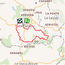
Trail Walking of 10.3 km to be discovered at Brittany, Côtes-d'Armor, Saint-Gildas. This trail is proposed by tracegps.

Description

Circuit proposé par l’office de Tourisme de Quintin communauté. Départ de la place de la mairie de St-Gildas. Découvrez St Gildas par ses nombreux chemins qui vous mèneront à travers la campagne. Retrouvez cette randonnée sur le site de l’office de Tourisme de Quintin communauté.

Elevation profile

Positioning

Country:
France
Region :
Brittany
Department/Province :
Côtes-d'Armor
Municipality :
Saint-Gildas
Location:
Unknown
Start:(UTM)
499744 ; 5363168 (30U) N.

Trails nearby

Trail On foot Saint-Fiacre - Circuit des tourbières - Photo
On foot
PRO

On foot

Easy
Saint-Fiacre, Brittany, Côtes-d'Armor, France
6.3 km | 7.6 km-effort
1h 43min
Yes
Trail Walking Saint-Gildas - rando saint gildas le leslay - Photo
Walking
chp8l8

Walking

Very easy
Saint-Gildas, Brittany, Côtes-d'Armor, France
21 km | 24 km-effort
Unknown
No


Close
My subscriptions