![](/images/other/stat-length.png)
![Trail Walking Bellecombe-Tarendol - Bellecombe Tarendol - Le Poët Sigillat - Photo](https://media.geolcdn.com/t/1900/400/ext.pjpeg?maxdim=2&url=https%3A%2F%2Fservices.sitytrail.com%2FGeolivesWS%2FDownloadMedia.ashx%3FTrailID%3D105353%26Media%3D9055_1.jpg)
Bellecombe Tarendol - Le Poët Sigillat
tracegps
User
![Length](/images/other/stat-length.png)
![Max alt](https://static1.geolcdn.com/siteimages/upload/files/1508320355ic_sort_altitude_max_24dp.png)
![Uphill gradient](https://static1.geolcdn.com/siteimages/upload/files/1508320355ic_sort_den_pos_24dp.png)
![Km-Effort](/images/other/stat-length.png)
![Min alt](https://static1.geolcdn.com/siteimages/upload/files/1508320355ic_sort_altitude_min_24dp.png)
![Downhill gradient](https://static1.geolcdn.com/siteimages/upload/files/1508320355ic_sort_den_neg_24dp.png)
![Boucle](https://static1.geolcdn.com/siteimages/upload/files/16400158638029165_repeat_loop_refresh_sync_direction_icon.png)
![Walking](https://static1.geolcdn.com/sitytour/trail-icons/101.png)
5h00
Difficulty : Medium
![Scan this QR Code to open this trail in the SityTrail application](https://capi.geolives.com/qq0zvz2zws4bq2lad0pu/sitytour/trails/105353/qr.png?size=200)
FREE GPS app for hiking
About
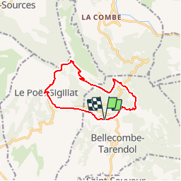
Trail Walking of 11.4 km to be discovered at Auvergne-Rhône-Alpes, Drôme, Bellecombe-Tarendol. This trail is proposed by tracegps.
Description
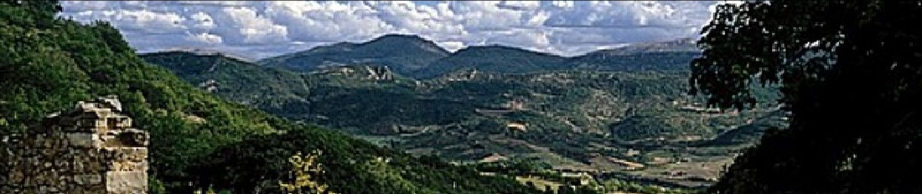
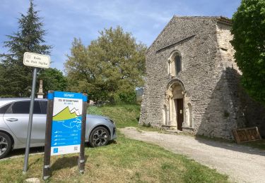
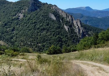
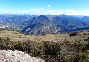
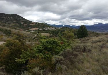
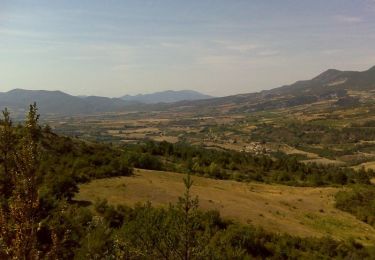
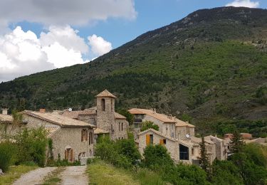
Le 08 Avril 2010 Nous rejoignions Tarendol sans encombre et à la sortie des voitures, un vent froid nous surprend. Les derniers préparatifs sont donc vite expédiés et c’est avec plaisir que nous attaquons la montée qui va nous conduire au col de Soubeyrand à 990 m d’altitude. Nous contournons le Charamelet et longeons le Plan d’Aubre pour atteindre le pylône de télécommunication qui sera le point culminant de notre randonnée du jour. Il est alors presque midi et l’horloge biologique de certains commence à manifester quelques signes d’impatience ; nous recherchons alors un coin abrité pour nous restaurer car le vent du nord à près de 1300 m d’altitude est froid et violent et ne nous incite pas à une contemplation passive et sans borne du paysage par ailleurs fort beau et ce tout au long de la balade. Le repas se déroule dans l’habituelle convivialité sous le regard d’un Ventoux enneigé par une chute de neige de la veille. La station assise, malgré les calories absorbées au cours du repas et des libations diverses qui l’accompagnent, se traduit assez vite par une sensation de froid qui nous amène à reprendre la route sans tarder. Direction le col d’Ambonne que nous atteignons rapidement. Une longue descente très pentue nous amène au village de Poët-Sigillat. Nous suivons la D568 pendant quelques centaines de mètres puis la quittons sur la droite pour rejoindre Tarendol et nos voitures par un sentier plus poétique que la départementale. Au passage, nous nous attardons un instant au cimetière de Tarendol où repose l’écrivain René Barjavel décédé en 1985.
Positioning
Comments
Trails nearby
![Trail Road bike Sainte-Jalle - Col d’Ey depuis Sainte Jalle via Rochebrune - Photo](https://media.geolcdn.com/t/375/260/2d32934e-f0a5-4ec9-8fdb-ba37b4d45c7a.jpg&format=jpg&maxdim=2)
![Road bike Road bike](https://static1.geolcdn.com/sitytour/trail-icons/201.png)
Road bike
![](/images/other/stat-length.png)
![](https://static1.geolcdn.com/siteimages/upload/files/16400158638029165_repeat_loop_refresh_sync_direction_icon.png)
![Trail Walking Le Poët-Sigillat - poët Sigillat-col de Soubeyrand-Tarendol - Photo](https://media.geolcdn.com/t/375/260/62191b6d-cd1d-491d-b6a6-a8d2adebac5d.jpg&format=jpg&maxdim=2)
![Walking Walking](https://static1.geolcdn.com/sitytour/trail-icons/101.png)
Walking
![](/images/other/stat-length.png)
![](https://static1.geolcdn.com/siteimages/upload/files/16400158638029165_repeat_loop_refresh_sync_direction_icon.png)
![Trail Walking Montréal-les-Sources - Montréal les Sources 12km - Photo](https://media.geolcdn.com/t/375/260/85d16ab9-cc78-4106-9f58-44413d453253.jpg&format=jpg&maxdim=2)
![Walking Walking](https://static1.geolcdn.com/sitytour/trail-icons/101.png)
Walking
![](/images/other/stat-length.png)
![](https://static1.geolcdn.com/siteimages/upload/files/16400158638029165_repeat_loop_refresh_sync_direction_icon.png)
![Trail Walking Sainte-Jalle - GRP Baronnies Ste Jalle Arpavon 18km - Photo](https://media.geolcdn.com/t/375/260/8bd5c524-a80b-4e1f-b0f8-b1a379789e0d.jpg&format=jpg&maxdim=2)
![Walking Walking](https://static1.geolcdn.com/sitytour/trail-icons/101.png)
Walking
![](/images/other/stat-length.png)
![](https://static1.geolcdn.com/siteimages/upload/files/16400158638029165_repeat_loop_refresh_sync_direction_icon.png)
![Trail Walking Bésignan - Autour du rocher des Mieyes - Besignan - Photo](https://media.geolcdn.com/t/375/260/ext.jpg?maxdim=2&url=https%3A%2F%2Fservices.sitytrail.com%2FGeolivesWS%2FDownloadMedia.ashx%3FTrailID%3D173089%26Media%3D14633_6.jpg)
![Walking Walking](https://static1.geolcdn.com/sitytour/trail-icons/101.png)
Walking
![](/images/other/stat-length.png)
![](https://static1.geolcdn.com/siteimages/upload/files/16400158638029165_repeat_loop_refresh_sync_direction_icon.png)
![Trail Mountain bike Le Poët-Sigillat - La Grande Javonière - Photo](https://media.geolcdn.com/t/375/260/ext.jpg?maxdim=2&url=https%3A%2F%2Fservices.sitytrail.com%2FGeolivesWS%2FDownloadMedia.ashx%3FTrailID%3D103221%26Media%3D5104_6.jpg)
![Mountain bike Mountain bike](https://static1.geolcdn.com/sitytour/trail-icons/202.png)
Mountain bike
![](/images/other/stat-length.png)
![](https://static1.geolcdn.com/siteimages/upload/files/16400158638029165_repeat_loop_refresh_sync_direction_icon.png)
![Trail Walking Le Poët-Sigillat - La Grande Javonière - Photo](https://media.geolcdn.com/t/375/260/ext.jpg?maxdim=2&url=https%3A%2F%2Fservices.sitytrail.com%2FGeolivesWS%2FDownloadMedia.ashx%3FTrailID%3D103220%26Media%3D5104_6.jpg)
![Walking Walking](https://static1.geolcdn.com/sitytour/trail-icons/101.png)
Walking
![](/images/other/stat-length.png)
![](https://static1.geolcdn.com/siteimages/upload/files/16400158638029165_repeat_loop_refresh_sync_direction_icon.png)
![Trail Electric bike Saint-Sauveur-Gouvernet - 26 - col de Soubeyrand par St Sauveur G. et le Poet Sigillat - Photo](https://media.geolcdn.com/t/375/260/5cfb0fe2-ecff-4c08-911e-30e1e2650b99.jpg&format=jpg&maxdim=2)
![Electric bike Electric bike](https://static1.geolcdn.com/sitytour/trail-icons/205.png)
Electric bike
![](/images/other/stat-length.png)
![](https://static1.geolcdn.com/siteimages/upload/files/16400158638029165_repeat_loop_refresh_sync_direction_icon.png)
![Trail Walking Montréal-les-Sources - Montréal Les sources - Photo](https://media.geolcdn.com/t/375/260/330e83f8-0d36-4e5f-9026-a696d6555318.jpg&format=jpg&maxdim=2)
![Walking Walking](https://static1.geolcdn.com/sitytour/trail-icons/101.png)
Walking
![](/images/other/stat-length.png)
![](https://static1.geolcdn.com/siteimages/upload/files/16400158638029165_repeat_loop_refresh_sync_direction_icon.png)