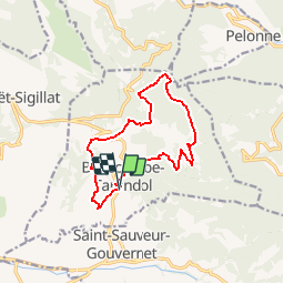
![](/images/other/stat-length.png)
![Trail Walking Bellecombe-Tarendol - Bellecombe Tarendol - Rocher du Banc - Photo](https://media.geolcdn.com/t/1900/400/ext.pjpeg?maxdim=2&url=https%3A%2F%2Fservices.sitytrail.com%2FGeolivesWS%2FDownloadMedia.ashx%3FTrailID%3D105352%26Media%3D9054_2.jpg)
Bellecombe Tarendol - Rocher du Banc
tracegps
User
![Length](/images/other/stat-length.png)
![Max alt](https://static1.geolcdn.com/siteimages/upload/files/1508320355ic_sort_altitude_max_24dp.png)
![Uphill gradient](https://static1.geolcdn.com/siteimages/upload/files/1508320355ic_sort_den_pos_24dp.png)
![Km-Effort](/images/other/stat-length.png)
![Min alt](https://static1.geolcdn.com/siteimages/upload/files/1508320355ic_sort_altitude_min_24dp.png)
![Downhill gradient](https://static1.geolcdn.com/siteimages/upload/files/1508320355ic_sort_den_neg_24dp.png)
![Boucle](https://static1.geolcdn.com/siteimages/upload/files/16400158638029165_repeat_loop_refresh_sync_direction_icon.png)
![Walking](https://static1.geolcdn.com/sitytour/trail-icons/101.png)
5h00
Difficulty : Medium
![Scan this QR Code to open this trail in the SityTrail application](https://capi.geolives.com/qq0zvz2zws4bq2lad0pu/sitytour/trails/105352/qr.png?size=200)
FREE GPS app for hiking
About
Trail Walking of 12.5 km to be discovered at Auvergne-Rhône-Alpes, Drôme, Bellecombe-Tarendol. This trail is proposed by tracegps.
Description
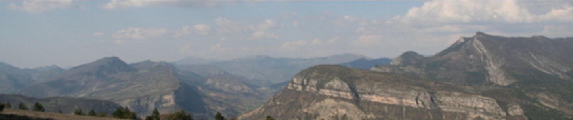
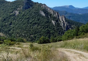
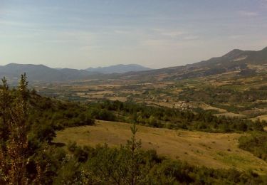
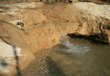
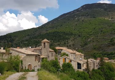
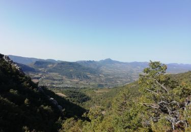
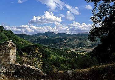
Journée particulièrement limpide et ensoleillée, avec quelques degrés de températures positives, agréables pour marcher. Nous sommes sous le petit village de Bellecombe. Nous montons à travers les vergers d’abricotiers tout nus puis longeons de belles marnes pour arriver au minuscule hameau de Tarendol. Le pèlerinage à la petite tombe de René Barjavel, écrivain, s’impose bien sûr. Le petit cimetière très dépouillé jouxte une jolie petite chapelle provençale face au Mont Ventoux enneigé. Notre sentier passe par le Bois de Brémond, non loin du Col de Soubeyrand. Les neiges fondues ont détrempé l’argile qui alourdit nos chaussures. Voilà le début d’une montée bien savonnée ! Heureusement que les genêts et les buis sont bien enracinés, nous leur tirons beaucoup les cheveux aujourd’hui ! Nous sommes un certain nombre à bien apprécier les mains secourables. Merci à elles ! Les premières traces de neige surgissent. Bientôt, c’est une épaisse couche de 20 cm que nous foulons longuement en une très, très longue ascension, avec une extrême prudence. Le paysage se dégage bientôt et nous surplombons la Vallée de l’Eygues et Rémuzat. De gauche à droite, chapeautées de blanc, les montagnes de Mélandre, d’Angèle et le Rocher de St May. Nous comptons bien profiter du spectacle depuis un replat qui nous invite opportunément à la pause de midi. Pour éviter d’avoir les fesses sur la neige, l’astuce consiste à couper des branches de buis pour se faire un petit coussin isolant. Puis le sentier grimpe toujours résolument, vers le Rocher du Banc, 1175 m, avec un horizon qui s’élargit à l’infini sur les Alpes. Au sommet, c’est l’apothéose, avec une vue à 360°, permettant d’embrasser à la ronde Le Mont Ventoux, la Vanige, Buc, Chamouse, les Alpes et l’Obiou caché derrière les préalpes moutonnantes toutes proches, Angèle, et même, tout au loin, en filigrane, on devine les Cévennes. Personne ne proteste si la descente est encore un peu scabreuse, dans la neige et la boue. Un autre moment impressionnant, sur la route du retour vers Bellecombe, c’est le passage dans la clue de l’Aiglier, au milieu d’immenses crêtes rocheuses déchiquetées toutes dorées au soleil couchant.
Positioning
Comments
Trails nearby
![Trail Walking Le Poët-Sigillat - poët Sigillat-col de Soubeyrand-Tarendol - Photo](https://media.geolcdn.com/t/375/260/62191b6d-cd1d-491d-b6a6-a8d2adebac5d.jpg&format=jpg&maxdim=2)
![Walking Walking](https://static1.geolcdn.com/sitytour/trail-icons/101.png)
Walking
![](/images/other/stat-length.png)
![](https://static1.geolcdn.com/siteimages/upload/files/16400158638029165_repeat_loop_refresh_sync_direction_icon.png)
![Trail Walking Bésignan - Autour du rocher des Mieyes - Besignan - Photo](https://media.geolcdn.com/t/375/260/ext.jpg?maxdim=2&url=https%3A%2F%2Fservices.sitytrail.com%2FGeolivesWS%2FDownloadMedia.ashx%3FTrailID%3D173089%26Media%3D14633_6.jpg)
![Walking Walking](https://static1.geolcdn.com/sitytour/trail-icons/101.png)
Walking
![](/images/other/stat-length.png)
![](https://static1.geolcdn.com/siteimages/upload/files/16400158638029165_repeat_loop_refresh_sync_direction_icon.png)
![Trail Mountain bike Le Poët-Sigillat - La Grande Javonière - Photo](https://media.geolcdn.com/t/375/260/ext.jpg?maxdim=2&url=https%3A%2F%2Fservices.sitytrail.com%2FGeolivesWS%2FDownloadMedia.ashx%3FTrailID%3D103221%26Media%3D5104_6.jpg)
![Mountain bike Mountain bike](https://static1.geolcdn.com/sitytour/trail-icons/202.png)
Mountain bike
![](/images/other/stat-length.png)
![](https://static1.geolcdn.com/siteimages/upload/files/16400158638029165_repeat_loop_refresh_sync_direction_icon.png)
![Trail Walking Le Poët-Sigillat - La Grande Javonière - Photo](https://media.geolcdn.com/t/375/260/ext.jpg?maxdim=2&url=https%3A%2F%2Fservices.sitytrail.com%2FGeolivesWS%2FDownloadMedia.ashx%3FTrailID%3D103220%26Media%3D5104_6.jpg)
![Walking Walking](https://static1.geolcdn.com/sitytour/trail-icons/101.png)
Walking
![](/images/other/stat-length.png)
![](https://static1.geolcdn.com/siteimages/upload/files/16400158638029165_repeat_loop_refresh_sync_direction_icon.png)
![Trail Electric bike Saint-Sauveur-Gouvernet - 26 - col de Soubeyrand par St Sauveur G. et le Poet Sigillat - Photo](https://media.geolcdn.com/t/375/260/5cfb0fe2-ecff-4c08-911e-30e1e2650b99.jpg&format=jpg&maxdim=2)
![Electric bike Electric bike](https://static1.geolcdn.com/sitytour/trail-icons/205.png)
Electric bike
![](/images/other/stat-length.png)
![](https://static1.geolcdn.com/siteimages/upload/files/16400158638029165_repeat_loop_refresh_sync_direction_icon.png)
![Trail Walking Saint-Sauveur-Gouvernet - La Bâtie Verdun-La Vanige 10km - Photo](https://media.geolcdn.com/t/375/260/d1982dba-00f0-44c6-92cc-49d252f589fb.jpg&format=jpg&maxdim=2)
![Walking Walking](https://static1.geolcdn.com/sitytour/trail-icons/101.png)
Walking
![](/images/other/stat-length.png)
![](https://static1.geolcdn.com/siteimages/upload/files/16400158638029165_repeat_loop_refresh_sync_direction_icon.png)
![Trail Walking Bellecombe-Tarendol - Bellecombe Tarendol - Le Poët Sigillat - Photo](https://media.geolcdn.com/t/375/260/ext.jpg?maxdim=2&url=https%3A%2F%2Fservices.sitytrail.com%2FGeolivesWS%2FDownloadMedia.ashx%3FTrailID%3D105353%26Media%3D9055_1.jpg)
![Walking Walking](https://static1.geolcdn.com/sitytour/trail-icons/101.png)
Walking
![](/images/other/stat-length.png)
![](https://static1.geolcdn.com/siteimages/upload/files/16400158638029165_repeat_loop_refresh_sync_direction_icon.png)
![Trail Walking Le Poët-Sigillat - SityTrail - La Grande Javonière - Photo](https://media.geolcdn.com/t/375/260/ext.jpg?maxdim=2&url=https%3A%2F%2Fstatic1.geolcdn.com%2Fsiteimages%2Fupload%2Ffiles%2F1553511878bg_sport_marche.png)
![Walking Walking](https://static1.geolcdn.com/sitytour/trail-icons/101.png)
Walking
![](/images/other/stat-length.png)
![](https://static1.geolcdn.com/siteimages/upload/files/16400158638029165_repeat_loop_refresh_sync_direction_icon.png)
![Trail Walking Bellecombe-Tarendol - Cols Soubeyrand - Ambaune - Photo](https://media.geolcdn.com/t/375/260/ext.jpg?maxdim=2&url=https%3A%2F%2Fstatic1.geolcdn.com%2Fsiteimages%2Fupload%2Ffiles%2F1553511878bg_sport_marche.png)
![Walking Walking](https://static1.geolcdn.com/sitytour/trail-icons/101.png)
Walking
![](/images/other/stat-length.png)
![](https://static1.geolcdn.com/siteimages/upload/files/16400158638029165_repeat_loop_refresh_sync_direction_icon.png)