Trail Running Pechbusque - Singles à Pech David - Pechbusque - Photo

Singles à Pech David - Pechbusque

 tracegps
tracegps

User

© OpenStreetMap contributors
Length
Length
30 km
Max alt
Max alt
280 m
Uphill gradient
Uphill gradient
775 m
Km-Effort
Km-Effort  
40 km
Min alt
Min alt
162 m
Downhill gradient
Downhill gradient
768 m
Boucle
Boucle
Yes
Creation date :
2014-12-10 00:00:00.0
Updated on :
2014-12-10 00:00:00.0

(0 Reviews)

Running
Running
3h30
Difficulty : Very difficult

Scan this QR Code to open this trail in the SityTrail application

FREE GPS app for hiking

Logo SityTrail SityTrail

IGN / Geographical institutes

Download SityTrail from the App Store Download SityTrail from Google Play

Logo SityTrail SityTrail World

The world is yours!

Download SityTrail from the App Store Download SityTrail from Google Play Download SityTrail on Huawei AppGallery

About

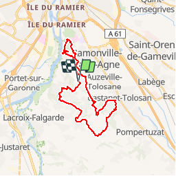
Trail Running of 30 km to be discovered at Occitania, Haute-Garonne, Pechbusque. This trail is proposed by tracegps.

Description

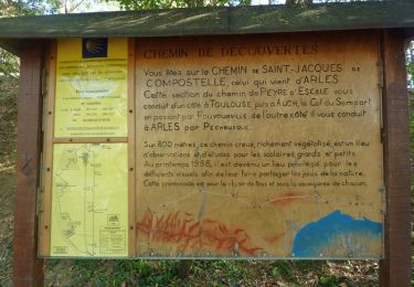
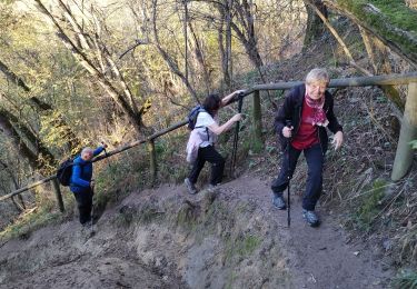
Ce circuit fait découvrir la plupart des plus beaux singles des coteaux de Pech David. Physiquement éprouvant et techniquement assez difficile, c'est un excellent parcour d'entrainement pour les VTTistes aguerris ou pour les amateurs de trails longs. Les pentes y sont souvent raides à la montée comme à la descente. Les rares parcours de liaison entre les singles sont appréciés pour récupérer un peu. En période humide, le terrain gras ajoute encore à la difficulté. Bien sur on peut raccourcir la boucle en divers endroits pour profiter des singles en plusieurs fois. Le départ est proposé depuis Pechbusque mais le circuit peut aussi être entamé depuis Toulouse à la base verte de Pech David, depuis Ramonville à la tour Télécoms ou à Castanet depuis le centre du village. Bonne balade!

Elevation profile

Positioning

Country:
France
Region :
Occitania
Department/Province :
Haute-Garonne
Municipality :
Pechbusque
Location:
Unknown
Start:(UTM)
375275 ; 4820746 (31T) N.

Trails nearby

Trail Walking Pinsaguel - PINSAGUEL : sentier de la Confluence (24.08.2023) - Photo
Walking
chrisgps

Walking

Very easy
Pinsaguel, Occitania, Haute-Garonne, France
3.8 km | 4.4 km-effort
1h 15min
Yes
Trail Walking Castanet-Tolosan - casranzt fait - Photo
Walking
pidjam

Walking

Very easy
(1)
Castanet-Tolosan, Occitania, Haute-Garonne, France
10.5 km | 12.6 km-effort
2h 26min
Yes
Trail Walking Lacroix-Falgarde - Promenade dominicale autour de Lacroix Falgarde - Photo
Walking
tracegps

Walking

Easy
Lacroix-Falgarde, Occitania, Haute-Garonne, France
8.6 km | 9.8 km-effort
2h 15min
Yes
Trail Walking Castanet-Tolosan - Boucle de Savignol  -  Castanet-Tolosan - Photo
Walking
tracegps

Walking

Medium
Castanet-Tolosan, Occitania, Haute-Garonne, France
10 km | 12.2 km-effort
2h 30min
Yes
Trail Walking Lacroix-Falgarde - Lacroix Falgarde - Goyrans - Photo
Walking
tracegps

Walking

Medium
Lacroix-Falgarde, Occitania, Haute-Garonne, France
8 km | 10 km-effort
2h 0min
Yes
Trail Walking Lacroix-Falgarde - Ariège Garonne variante - Lacroix Falgarde - Photo
Walking
tracegps

Walking

Easy
Lacroix-Falgarde, Occitania, Haute-Garonne, France
8.3 km | 9.6 km-effort
2h 30min
Yes
Trail Walking Pechbusque - De Pechbusque à Auzeville Tolosane - Photo
Walking
tracegps

Walking

Medium
Pechbusque, Occitania, Haute-Garonne, France
11.2 km | 14.2 km-effort
3h 30min
Yes
Trail Walking Rebigue - Randonnée autour de Rebigue - Photo
Walking
tracegps

Walking

Medium
Rebigue, Occitania, Haute-Garonne, France
12.1 km | 15.8 km-effort
3h 15min
Yes
Trail Walking Toulouse - TT22 Bellefontaine variante - Photo
Walking

Walking

Medium
Toulouse, Occitania, Haute-Garonne, France
11 km | 12.3 km-effort
2h 0min
No


Close
My subscriptions