Trail Mountain bike Sainte-Croix-aux-Mines - Espace VTT FFC Val d'Argent - Circuit n°12 - Le circuit du Hury - Photo

Espace VTT FFC Val d'Argent - Circuit n°12 - Le circuit du Hury

 tracegps
tracegps

User

© OpenStreetMap contributors
Length
Length
12.9 km
Max alt
Max alt
696 m
Uphill gradient
Uphill gradient
410 m
Km-Effort
Km-Effort  
18.3 km
Min alt
Min alt
296 m
Downhill gradient
Downhill gradient
409 m
Boucle
Boucle
Yes
Creation date :
2014-12-10 00:00:00.0
Updated on :
2014-12-10 00:00:00.0

(0 Reviews)

Mountain bike
Mountain bike
1h19
Difficulty : Medium

Scan this QR Code to open this trail in the SityTrail application

FREE GPS app for hiking

Logo SityTrail SityTrail

IGN / Geographical institutes

Download SityTrail from the App Store Download SityTrail from Google Play

Logo SityTrail SityTrail World

The world is yours!

Download SityTrail from the App Store Download SityTrail from Google Play Download SityTrail on Huawei AppGallery

About

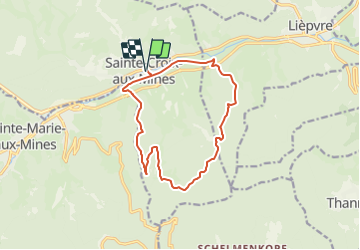
Trail Mountain bike of 12.9 km to be discovered at Grand Est, Haut-Rhin, Sainte-Croix-aux-Mines. This trail is proposed by tracegps.

Description

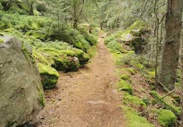
Espace VTT FFC Val d'Argent - Circuit n°12 - Le circuit du Hury Circuit officiel labellisé par la Fédération Française de Cyclisme. Départ : Parking situé à l’arrière de la mairie de Ste-Croix-aux-Mines. La longue portion ascendante de ce parcours est moins laborieuse qu’elle n’y paraît puisqu’elle emprunte une petite route goudronnée longeant le ruisseau de la Goutte St-Blaise. Et quel plaisir à la descente !! Le Hury doit son nom à l’extraction de la houille qui fut très importante jusqu’à la Révolution. L’endroit, initialement appelé houillerie a évolué pour devenir aujourd’hui « Hury ».

Elevation profile

Photos

Positioning

Country:
France
Region :
Grand Est
Department/Province :
Haut-Rhin
Municipality :
Sainte-Croix-aux-Mines
Location:
Unknown
Start:(UTM)
368393 ; 5346999 (32U) N.

Trails nearby

Trail Walking Sainte-Marie-aux-Mines - la croix de Ribeauvillé  - Photo
Walking
jean charles daniel.

Walking

Medium
Sainte-Marie-aux-Mines, Grand Est, Haut-Rhin, France
12.5 km | 18.1 km-effort
6h 2min
Yes
Trail Walking Breitenau - 2024-07-23_20h26m34_G 12 - Photo
Walking
LUTZMarc

Walking

Easy
(1)
Breitenau, Grand Est, Bas-Rhin, France
15.4 km | 22 km-effort
4h 59min
Yes
Trail sport Ribeauvillé - Grande verrerie - Rocher des Géants  - Photo
sport
berni68

sport

Very easy
Ribeauvillé, Grand Est, Haut-Rhin, France
9.3 km | 15.3 km-effort
Unknown
No
Trail Walking Sainte-Marie-aux-Mines - taenichel - Photo
Walking
apa

Walking

Medium
Sainte-Marie-aux-Mines, Grand Est, Haut-Rhin, France
13.3 km | 19.1 km-effort
5h 26min
Yes
Trail Walking Sainte-Marie-aux-Mines - Col du Haut de Ribeauvillé - Rochers des Géants (Rother n°31) - Photo
Walking
Bart2015

Walking

Medium
Sainte-Marie-aux-Mines, Grand Est, Haut-Rhin, France
15.3 km | 22 km-effort
3h 56min
Yes
Trail Walking Rombach-le-Franc - Col de Fouchy  - Photo
Walking
apa

Walking

Medium
Rombach-le-Franc, Grand Est, Haut-Rhin, France
11.8 km | 17.6 km-effort
3h 23min
Yes
Trail Walking Lièpvre - Liépvre - Roche des Fées, Roche de Chalmont, Rocher du Coucou, château du Frankenbourg - Photo
Walking
Bart2015

Walking

Difficult
Lièpvre, Grand Est, Haut-Rhin, France
19.4 km | 31 km-effort
5h 53min
Yes
Trail Walking Ribeauvillé - boucle la grande verrerie-roche des 3 tables-roche des reptiles-roche des géants-la grande verrerie  - Photo
Walking
fbienmuller

Walking

Medium
(1)
Ribeauvillé, Grand Est, Haut-Rhin, France
15 km | 23 km-effort
4h 24min
Yes
Trail Walking Ribeauvillé - 2021-07-17 Marche La Grande Verrerie Taennchel - Photo
Walking
GUIDE
holtzv

Walking

Medium
Ribeauvillé, Grand Est, Haut-Rhin, France
13.2 km | 21 km-effort
4h 41min
Yes


Close
My subscriptions