![](/images/other/stat-length.png)
![Trail Mountain bike Thorame-Basse - Tour de la Montagne de Chamatte en VTT - Thorame Basse - Photo](https://media.geolcdn.com/t/1900/400/ext.pjpeg?maxdim=2&url=https%3A%2F%2Fservices.sitytrail.com%2FGeolivesWS%2FDownloadMedia.ashx%3FTrailID%3D105143%26Media%3D8760_1.jpg)
Tour de la Montagne de Chamatte en VTT - Thorame Basse
tracegps
User
![Length](/images/other/stat-length.png)
![Max alt](https://static1.geolcdn.com/siteimages/upload/files/1508320355ic_sort_altitude_max_24dp.png)
![Uphill gradient](https://static1.geolcdn.com/siteimages/upload/files/1508320355ic_sort_den_pos_24dp.png)
![Km-Effort](/images/other/stat-length.png)
![Min alt](https://static1.geolcdn.com/siteimages/upload/files/1508320355ic_sort_altitude_min_24dp.png)
![Downhill gradient](https://static1.geolcdn.com/siteimages/upload/files/1508320355ic_sort_den_neg_24dp.png)
![Boucle](https://static1.geolcdn.com/siteimages/upload/files/16400158638029165_repeat_loop_refresh_sync_direction_icon.png)
![Mountain bike](https://static1.geolcdn.com/sitytour/trail-icons/202.png)
8h00
Difficulty : Very difficult
![Scan this QR Code to open this trail in the SityTrail application](https://capi.geolives.com/qq0zvz2zws4bq2lad0pu/sitytour/trails/105143/qr.png?size=200)
FREE GPS app for hiking
About
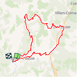
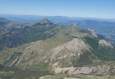
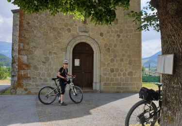
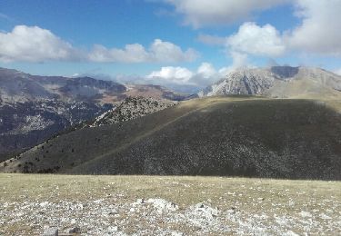
Trail Mountain bike of 48 km to be discovered at Provence-Alpes-Côte d'Azur, Alpes-de-Haute-Provence, Thorame-Basse. This trail is proposed by tracegps.
Description
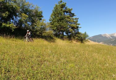
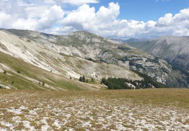
C'est du vrai vélo de montagne avec tous ses ingrédients variés : un soupçon de bitume, un peu de piste, beaucoup de sentiers plus ou moins techniques, et une bonne dose de portage. La beauté du cadre et les superbes et interminables descentes très roulantes valent bien quelques petits efforts. A la bifurcation juste après la cabane de Chalufy, je me suis laissé tenter par le sentier de Peymian, que j'ai trouvé un peu décevant. J'ai le projet d'y retourner et prendre la direction du col de Chalufy, et, pourquoi pas, porter le vélo et descendre depuis le sommet de Boules?( à voir sur place l'état d'une éventuelle descente)
Positioning
Comments
Trails nearby
![Trail Walking Thorame-Basse - 2023-11-24 Château Garnier - Cabane du Cheval Blanc - Photo](https://media.geolcdn.com/t/375/260/ab6f9133-5c27-4957-94a0-2d4ac22ea11a.jpg&format=jpg&maxdim=2)
![Walking Walking](https://static1.geolcdn.com/sitytour/trail-icons/101.png)
Walking
![](/images/other/stat-length.png)
![](https://static1.geolcdn.com/siteimages/upload/files/16400158638029165_repeat_loop_refresh_sync_direction_icon.png)
![Trail Mountain bike Thorame-Basse - Camping petit cordeil Argens - Photo](https://media.geolcdn.com/t/375/260/3c30eacb-045b-4112-8527-eaa21f175197.jpg&format=jpg&maxdim=2)
![Mountain bike Mountain bike](https://static1.geolcdn.com/sitytour/trail-icons/202.png)
Mountain bike
![](/images/other/stat-length.png)
![](https://static1.geolcdn.com/siteimages/upload/files/16400158638029165_repeat_loop_refresh_sync_direction_icon.png)
![Trail Walking Thorame-Basse - Thorame-Basse Cheval blanc 1300m 20kms - Photo](https://media.geolcdn.com/t/375/260/73b345a8-9859-446d-94b1-bad108bc50f1.jpg&format=jpg&maxdim=2)
![Walking Walking](https://static1.geolcdn.com/sitytour/trail-icons/101.png)
Walking
![](/images/other/stat-length.png)
![](https://static1.geolcdn.com/siteimages/upload/files/16400158638029165_repeat_loop_refresh_sync_direction_icon.png)
![Trail Walking La Mure-Argens - Montagne de Maurel - Photo](https://media.geolcdn.com/t/375/260/72f74087-2e56-4042-8755-c65eca535272.jpg&format=jpg&maxdim=2)
![Walking Walking](https://static1.geolcdn.com/sitytour/trail-icons/101.png)
Walking
![](/images/other/stat-length.png)
![](https://static1.geolcdn.com/siteimages/upload/files/16400158638029165_repeat_loop_refresh_sync_direction_icon.png)
![Trail Mountain bike Thorame-Basse - Le Tour des Villages - Photo](https://media.geolcdn.com/t/375/260/ec79a8ea-c080-47b6-9bf8-d0455c698ab3.jpg&format=jpg&maxdim=2)
![Mountain bike Mountain bike](https://static1.geolcdn.com/sitytour/trail-icons/202.png)
Mountain bike
![](/images/other/stat-length.png)
![](https://static1.geolcdn.com/siteimages/upload/files/16400158638029165_repeat_loop_refresh_sync_direction_icon.png)
![Trail Walking Thorame-Basse - Cheval Blanc - Photo](https://media.geolcdn.com/t/375/260/3bd55a47-d866-4512-9722-1e9ee3966f3a.jpg&format=jpg&maxdim=2)
![Walking Walking](https://static1.geolcdn.com/sitytour/trail-icons/101.png)
Walking
![](/images/other/stat-length.png)
![](https://static1.geolcdn.com/siteimages/upload/files/16400158638029165_repeat_loop_refresh_sync_direction_icon.png)
![Trail Mountain bike Thorame-Basse - Col de Seoune Lambruisse - Photo](https://media.geolcdn.com/t/375/260/ba2e047a-5809-43d1-ab8d-29e4616d993a.jpg&format=jpg&maxdim=2)
![Mountain bike Mountain bike](https://static1.geolcdn.com/sitytour/trail-icons/202.png)
Mountain bike
![](/images/other/stat-length.png)
![](https://static1.geolcdn.com/siteimages/upload/files/16400158638029165_repeat_loop_refresh_sync_direction_icon.png)
![Trail Mountain bike Thorame-Basse - Repérage Château Garnier - Photo](https://media.geolcdn.com/t/375/260/f365bc8c-cbca-4df4-8b10-894f6184d8ee.jpg&format=jpg&maxdim=2)
![Mountain bike Mountain bike](https://static1.geolcdn.com/sitytour/trail-icons/202.png)
Mountain bike
![](/images/other/stat-length.png)
![](https://static1.geolcdn.com/siteimages/upload/files/16400158638029165_repeat_loop_refresh_sync_direction_icon.png)
![Trail Walking Thorame-Basse - pic de mal-ubac - Photo](https://media.geolcdn.com/t/375/260/ext.jpg?maxdim=2&url=https%3A%2F%2Fservices.sitytrail.com%2FGeolivesWS%2FDownloadMedia.ashx%3FTrailID%3D648985%26Media%3Dfix__20161021125404.jpg)
![Walking Walking](https://static1.geolcdn.com/sitytour/trail-icons/101.png)
Walking
![](/images/other/stat-length.png)
![](https://static1.geolcdn.com/siteimages/upload/files/16400158638029165_repeat_loop_refresh_sync_direction_icon.png)