Trail Walking Tellancourt - Tellancourt 04 10 18 - Photo
© OpenStreetMap contributors
Length
Length
10.1 km
Max alt
Max alt
401 m
Uphill gradient
Uphill gradient
234 m
Km-Effort
Km-Effort  
13.2 km
Min alt
Min alt
227 m
Downhill gradient
Downhill gradient
238 m
Boucle
Boucle
Yes
Creation date :
2019-04-30 18:14:59.485
Updated on :
2019-04-30 18:14:59.546

(0 Reviews)

Walking
Walking
2h47
Difficulty : Easy

Scan this QR Code to open this trail in the SityTrail application

FREE GPS app for hiking

Logo SityTrail SityTrail

IGN / Geographical institutes

Download SityTrail from the App Store Download SityTrail from Google Play

Logo SityTrail SityTrail World

The world is yours!

Download SityTrail from the App Store Download SityTrail from Google Play Download SityTrail on Huawei AppGallery

About

Trail Walking of 10.1 km to be discovered at Grand Est, Meurthe-et-Moselle, Tellancourt. This trail is proposed by patdecosnes.

Description

club vosgien longuyon

Elevation profile

Positioning

Country:
France
Region :
Grand Est
Department/Province :
Meurthe-et-Moselle
Municipality :
Tellancourt
Location:
Unknown
Start:(UTM)
690577 ; 5487475 (31U) N.

Trails nearby

Trail On foot Virton - La Bajocienne - Photo
On foot
GUIDE+

On foot

Easy
(1)
Virton, Wallonia, Luxembourg, Belgium
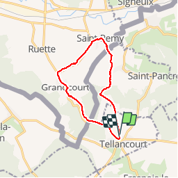
11 km | 14.5 km-effort
3h 17min
Yes
Trail Walking Cosnes-et-Romain - Saint-Denis 1 - Photo
Walking
Boumkassar

Walking

Medium
Cosnes-et-Romain, Grand Est, Meurthe-et-Moselle, France
7.4 km | 9.6 km-effort
1h 25min
No
Trail Walking Musson - Tour de la forêt des Monts. - Photo
Walking
Airelle

Walking

Very difficult
(1)
Musson, Wallonia, Luxembourg, Belgium
21 km | 28 km-effort
5h 28min
Yes
Trail Walking Saint-Pancré - Chemin des Minières - Photo
Walking
patrismichel

Walking

Medium
Saint-Pancré, Grand Est, Meurthe-et-Moselle, France
8.1 km | 9.7 km-effort
2h 15min
Yes
Trail Walking Villette - Villette 19-05-23 - Photo
Walking
patdecosnes

Walking

Easy
Villette, Grand Est, Meurthe-et-Moselle, France
3.9 km | 4.4 km-effort
59min
Yes
Trail Camping car Virton - Mesurage 9716 - Photo
Camping car
Maxime Léonard

Camping car

Very easy
Virton, Wallonia, Luxembourg, Belgium
146 km | 169 km-effort
3h 54min
Yes
Trail Walking Ville-Houdlémont - Balade 2 - Photo
Walking
Boumkassar

Walking

Easy
Ville-Houdlémont, Grand Est, Meurthe-et-Moselle, France
558 m | 728 m-effort
27min
No
Trail Walking Virton - La Charmouthienne_boucle_Gomery_15 km_2019-04-28 - Photo
Walking
bernardcollignon

Walking

Virton, Wallonia, Luxembourg, Belgium
15 km | 18.9 km-effort
4h 23min
Yes
Trail On foot Cons-la-Grandville - ugny 23.05.2024 - Photo
On foot
jcb48

On foot

Easy
Cons-la-Grandville, Grand Est, Meurthe-et-Moselle, France
7.3 km | 9.2 km-effort
2h 4min
Yes


Close
My subscriptions