Trail Walking Counozouls - Tour du Bénal - Photo

Tour du Bénal

 tracegps
tracegps

User

© OpenStreetMap contributors
Length
Length
11.6 km
Max alt
Max alt
1150 m
Uphill gradient
Uphill gradient
648 m
Km-Effort
Km-Effort  
20 km
Min alt
Min alt
600 m
Downhill gradient
Downhill gradient
640 m
Boucle
Boucle
Yes
Creation date :
2014-12-10 00:00:00.0
Updated on :
2014-12-10 00:00:00.0

(1 Reviews)

Walking
Walking
4h00
Difficulty : Difficult

Scan this QR Code to open this trail in the SityTrail application

FREE GPS app for hiking

Logo SityTrail SityTrail

IGN / Geographical institutes

Download SityTrail from the App Store Download SityTrail from Google Play

Logo SityTrail SityTrail World

The world is yours!

Download SityTrail from the App Store Download SityTrail from Google Play Download SityTrail on Huawei AppGallery

About

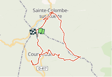
Trail Walking of 11.6 km to be discovered at Occitania, Aude, Counozouls. This trail is proposed by tracegps.

Description

A Sainte Colombe sur Guette se garer le long de la route au dessous de l'église. Revenir sur ses pas , traverser le pont. Vers le Pas Del Rec, il y a un ruisseau à traverser, difficile en cas d'eau abondante.

Elevation profile

Positioning

Country:
France
Region :
Occitania
Department/Province :
Aude
Municipality :
Counozouls
Location:
Unknown
Start:(Dec)
Start:(UTM)
436714 ; 4732103 (31T) N.

Comments

Please log in to post a review or rate the element


duylac


Trails nearby

Trail Walking Salvezines - Forêt d’enmalo - Photo
Walking
ezola

Walking

Difficult
Salvezines, Occitania, Aude, France
10.1 km | 16.9 km-effort
3h 24min
Yes
Trail Walking Salvezines - Le Caunil. Maison forestière par Puylaurens  - Photo
Walking
robertperello

Walking

Difficult
Salvezines, Occitania, Aude, France
10 km | 16.2 km-effort
2h 45min
Yes
Trail Walking Roquefort-de-Sault - Roquefort de Sault, sentier de l'Escalibat - Photo
Walking
Santblasi

Walking

Medium
Roquefort-de-Sault, Occitania, Aude, France
12.2 km | 16.8 km-effort
4h 30min
Yes
Trail Walking Salvezines - Tour du pic d'Estable - Photo
Walking
MALAUCLA

Walking

Easy
Salvezines, Occitania, Aude, France
10.1 km | 17 km-effort
3h 39min
Yes
Trail Walking Salvezines - fore - Photo
Walking
mvge

Walking

Medium
Salvezines, Occitania, Aude, France
9 km | 17.2 km-effort
1h 41min
No
Trail Walking Sainte-Colombe-sur-Guette - pic du dourmidou - Photo
Walking
j2c11

Walking

Very difficult
Sainte-Colombe-sur-Guette, Occitania, Aude, France
15.3 km | 32 km-effort
6h 19min
Yes
Trail Walking Sainte-Colombe-sur-Guette - pic de dourmidou - Photo
Walking
j2c11

Walking

Very difficult
Sainte-Colombe-sur-Guette, Occitania, Aude, France
17.5 km | 35 km-effort
6h 53min
Yes


Close
My subscriptions