![](/images/other/stat-length.png)
![Trail Mountain bike Champfrémont - Champfrémont, Forêt de Multonne, Pré en Pail - Photo](https://media.geolcdn.com/t/1900/400/ext.pjpeg?maxdim=2&url=https%3A%2F%2Fstatic1.geolcdn.com%2Fsiteimages%2Fupload%2Ffiles%2F1524743154velo.jpg)
Champfrémont, Forêt de Multonne, Pré en Pail
tracegps
User
![Length](/images/other/stat-length.png)
![Max alt](https://static1.geolcdn.com/siteimages/upload/files/1508320355ic_sort_altitude_max_24dp.png)
![Uphill gradient](https://static1.geolcdn.com/siteimages/upload/files/1508320355ic_sort_den_pos_24dp.png)
![Km-Effort](/images/other/stat-length.png)
![Min alt](https://static1.geolcdn.com/siteimages/upload/files/1508320355ic_sort_altitude_min_24dp.png)
![Downhill gradient](https://static1.geolcdn.com/siteimages/upload/files/1508320355ic_sort_den_neg_24dp.png)
![Boucle](https://static1.geolcdn.com/siteimages/upload/files/16400158638029165_repeat_loop_refresh_sync_direction_icon.png)
![Mountain bike](https://static1.geolcdn.com/sitytour/trail-icons/202.png)
2h19
Difficulty : Medium
![Scan this QR Code to open this trail in the SityTrail application](https://capi.geolives.com/qq0zvz2zws4bq2lad0pu/sitytour/trails/104894/qr.png?size=200)
FREE GPS app for hiking
About
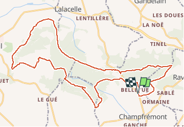
Trail Mountain bike of 25 km to be discovered at Pays de la Loire, Mayenne, Champfrémont. This trail is proposed by tracegps.
Description
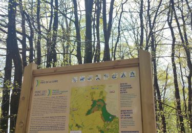
Ce circuit vous permet de découvrir la forêt de Multonne et le Belvédère des Avaloirs. Circuit sans grandes difficultés. Vraiment une belle boucle avec des chemins larges et roulants. Vous emprunterez aussi une partie du GR du Mont Saint Michel qui marque la limite entre la Basse Normandie et les Pays de la Loire.
Positioning
Comments
Trails nearby
![Trail On foot Pré-en-Pail-Saint-Samson - Boucle du Belvédère - Photo](https://media.geolcdn.com/t/375/260/86b01962-ba47-4a09-9125-4e227880329e.jpeg&format=jpg&maxdim=2)
![On foot On foot](https://static1.geolcdn.com/sitytour/trail-icons/100.png)
On foot
![](/images/other/stat-length.png)
![](https://static1.geolcdn.com/siteimages/upload/files/16400158638029165_repeat_loop_refresh_sync_direction_icon.png)
![Trail On foot Saint-Pierre-des-Nids - Boucle du Moulin de Campas - Photo](https://media.geolcdn.com/t/375/260/98d53c49-9a56-4f6a-b411-1cf56960c8d1.jpeg&format=jpg&maxdim=2)
![On foot On foot](https://static1.geolcdn.com/sitytour/trail-icons/100.png)
On foot
![](/images/other/stat-length.png)
![](https://static1.geolcdn.com/siteimages/upload/files/16400158638029165_repeat_loop_refresh_sync_direction_icon.png)
![Trail On foot Ravigny - Chemin des 4 Saisons et des 5 Sens - Photo](https://media.geolcdn.com/t/375/260/795a9570-cdb6-408f-8e2b-549f63a6d1c5.jpeg&format=jpg&maxdim=2)
![On foot On foot](https://static1.geolcdn.com/sitytour/trail-icons/100.png)
On foot
![](/images/other/stat-length.png)
![](https://static1.geolcdn.com/siteimages/upload/files/16400158638029165_repeat_loop_refresh_sync_direction_icon.png)
![Trail On foot Champfrémont - Sentier de Courtemiche - Photo](https://media.geolcdn.com/t/375/260/b07ef803-4de5-4243-9431-d78f0fa57af2.jpeg&format=jpg&maxdim=2)
![On foot On foot](https://static1.geolcdn.com/sitytour/trail-icons/100.png)
On foot
![](/images/other/stat-length.png)
![](https://static1.geolcdn.com/siteimages/upload/files/16400158638029165_repeat_loop_refresh_sync_direction_icon.png)
![Trail On foot Gandelain - Sentier de Multonne - Photo](https://media.geolcdn.com/t/375/260/795a9570-cdb6-408f-8e2b-549f63a6d1c5.jpeg&format=jpg&maxdim=2)
![On foot On foot](https://static1.geolcdn.com/sitytour/trail-icons/100.png)
On foot
![](/images/other/stat-length.png)
![](https://static1.geolcdn.com/siteimages/upload/files/16400158638029165_repeat_loop_refresh_sync_direction_icon.png)
![Trail On foot Pré-en-Pail-Saint-Samson - Circuit des Avaloirs - Photo](https://media.geolcdn.com/t/375/260/86b01962-ba47-4a09-9125-4e227880329e.jpeg&format=jpg&maxdim=2)
![On foot On foot](https://static1.geolcdn.com/sitytour/trail-icons/100.png)
On foot
![](/images/other/stat-length.png)
![](https://static1.geolcdn.com/siteimages/upload/files/16400158638029165_repeat_loop_refresh_sync_direction_icon.png)
![Trail On foot Champfrémont - Sentier des écoliers - Photo](https://media.geolcdn.com/t/375/260/795a9570-cdb6-408f-8e2b-549f63a6d1c5.jpeg&format=jpg&maxdim=2)
![On foot On foot](https://static1.geolcdn.com/sitytour/trail-icons/100.png)
On foot
![](/images/other/stat-length.png)
![](https://static1.geolcdn.com/siteimages/upload/files/16400158638029165_repeat_loop_refresh_sync_direction_icon.png)
![Trail Walking Pré-en-Pail-Saint-Samson - Autour du Belvédère - Photo](https://media.geolcdn.com/t/375/260/e594d5f7-55fc-4333-b9ab-fb44dad45550.jpg&format=jpg&maxdim=2)
![Walking Walking](https://static1.geolcdn.com/sitytour/trail-icons/101.png)
Walking
![](/images/other/stat-length.png)
![](https://static1.geolcdn.com/siteimages/upload/files/16400158638029165_repeat_loop_refresh_sync_direction_icon.png)
![Trail Walking Champfrémont - Boucle de Multonne - Photo](https://media.geolcdn.com/t/375/260/30bdb1ef-ee48-4799-8cb1-9b04d0a24eb0.jpg&format=jpg&maxdim=2)
![Walking Walking](https://static1.geolcdn.com/sitytour/trail-icons/101.png)
Walking
![](/images/other/stat-length.png)
![](https://static1.geolcdn.com/siteimages/upload/files/16400158638029165_repeat_loop_refresh_sync_direction_icon.png)