![](/images/other/stat-length.png)
![Trail Equestrian Unieux - Balade du Lizeron - Unieux - Photo](https://media.geolcdn.com/t/1900/400/ext.pjpeg?maxdim=2&url=https%3A%2F%2Fservices.sitytrail.com%2FGeolivesWS%2FDownloadMedia.ashx%3FTrailID%3D104883%26Media%3D8410_3.jpg)
Balade du Lizeron - Unieux
tracegps
User
![Length](/images/other/stat-length.png)
Length
18.5 km
![Max alt](https://static1.geolcdn.com/siteimages/upload/files/1508320355ic_sort_altitude_max_24dp.png)
Max alt
692 m
![Uphill gradient](https://static1.geolcdn.com/siteimages/upload/files/1508320355ic_sort_den_pos_24dp.png)
Uphill gradient
606 m
![Km-Effort](/images/other/stat-length.png)
Km-Effort
27 km
![Min alt](https://static1.geolcdn.com/siteimages/upload/files/1508320355ic_sort_altitude_min_24dp.png)
Min alt
421 m
![Downhill gradient](https://static1.geolcdn.com/siteimages/upload/files/1508320355ic_sort_den_neg_24dp.png)
Downhill gradient
605 m
![Boucle](https://static1.geolcdn.com/siteimages/upload/files/16400158638029165_repeat_loop_refresh_sync_direction_icon.png)
Boucle
Yes
Creation date :
2014-12-10 00:00:00.0
Updated on :
2014-12-10 00:00:00.0
![Equestrian](https://static1.geolcdn.com/sitytour/trail-icons/300.png)
4h04
Difficulty : Difficult
![Scan this QR Code to open this trail in the SityTrail application](https://capi.geolives.com/qq0zvz2zws4bq2lad0pu/sitytour/trails/104883/qr.png?size=200)
FREE GPS app for hiking
About
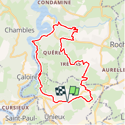
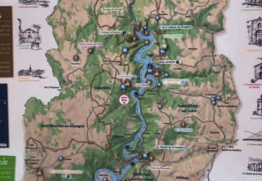
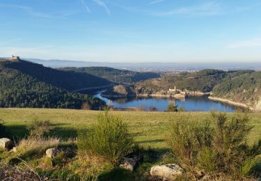
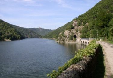
Trail Equestrian of 18.5 km to be discovered at Auvergne-Rhône-Alpes, Loire, Unieux. This trail is proposed by tracegps.
Description
J'ai mis difficile pour ne pas surprendre les cavaliers, car : - il y a du dénivelé - une bonne descente (à pied de préférence) après la Giletière - une partie à pied obligatoire (marches en rochers)avant les Revotes
Positioning
Country:
France
Region :
Auvergne-Rhône-Alpes
Department/Province :
Loire
Municipality :
Unieux
Location:
Unknown
Start:(Dec)
Start:(UTM)
599485 ; 5028870 (31T) N.
Comments
Trails nearby
![Trail Mountain bike Saint-Genest-Lerpt - Rando VTT Les Balades d'automne - Saint Genest Lerpt - Photo](https://media.geolcdn.com/t/375/260/ext.jpg?maxdim=2&url=https%3A%2F%2Fservices.sitytrail.com%2FGeolivesWS%2FDownloadMedia.ashx%3FTrailID%3D107357%26Media%3D12248_6.jpg)
![Mountain bike Mountain bike](https://static1.geolcdn.com/sitytour/trail-icons/202.png)
Rando VTT Les Balades d'automne - Saint Genest Lerpt
Mountain bike
Very difficult
(1)
Saint-Genest-Lerpt,
Auvergne-Rhône-Alpes,
Loire,
France
![](/images/other/stat-length.png)
49 km | 63 km-effort
3h 30min
![](https://static1.geolcdn.com/siteimages/upload/files/16400158638029165_repeat_loop_refresh_sync_direction_icon.png)
Yes
![Trail Walking Chambles - Chambles -Essalois - Notre dame de Grâce - Photo](https://media.geolcdn.com/t/375/260/954bcd02-41dd-4bd9-9752-da9ba6f2c6c2.jpg&format=jpg&maxdim=2)
![Walking Walking](https://static1.geolcdn.com/sitytour/trail-icons/101.png)
Chambles -Essalois - Notre dame de Grâce
Walking
Medium
Chambles,
Auvergne-Rhône-Alpes,
Loire,
France
![](/images/other/stat-length.png)
13.5 km | 18.8 km-effort
3h 40min
![](https://static1.geolcdn.com/siteimages/upload/files/16400158638029165_repeat_loop_refresh_sync_direction_icon.png)
Yes
![Trail Walking Chambles - Chambres,Barrage Grangent, - Photo](https://media.geolcdn.com/t/375/260/c0e5255d-ba6d-48c9-b079-d69023db0bb9.jpg&format=jpg&maxdim=2)
![Walking Walking](https://static1.geolcdn.com/sitytour/trail-icons/101.png)
Chambres,Barrage Grangent,
Walking
Easy
Chambles,
Auvergne-Rhône-Alpes,
Loire,
France
![](/images/other/stat-length.png)
11 km | 16.4 km-effort
2h 54min
![](https://static1.geolcdn.com/siteimages/upload/files/16400158638029165_repeat_loop_refresh_sync_direction_icon.png)
Yes
![Trail Walking Saint-Étienne - ST VICTOR 16km 502 - Photo](https://media.geolcdn.com/t/375/260/ext.jpg?maxdim=2&url=https%3A%2F%2Fstatic1.geolcdn.com%2Fsiteimages%2Fupload%2Ffiles%2F1553511878bg_sport_marche.png)
![Walking Walking](https://static1.geolcdn.com/sitytour/trail-icons/101.png)
ST VICTOR 16km 502
Walking
Very difficult
(1)
Saint-Étienne,
Auvergne-Rhône-Alpes,
Loire,
France
![](/images/other/stat-length.png)
16 km | 23 km-effort
5h 9min
![](https://static1.geolcdn.com/siteimages/upload/files/16400158638029165_repeat_loop_refresh_sync_direction_icon.png)
Yes
![Trail Walking Unieux - gorges de la Loire - Photo](https://media.geolcdn.com/t/375/260/ext.jpg?maxdim=2&url=https%3A%2F%2Fstatic1.geolcdn.com%2Fsiteimages%2Fupload%2Ffiles%2F1553511878bg_sport_marche.png)
![Walking Walking](https://static1.geolcdn.com/sitytour/trail-icons/101.png)
gorges de la Loire
Walking
Medium
(1)
Unieux,
Auvergne-Rhône-Alpes,
Loire,
France
![](/images/other/stat-length.png)
12.8 km | 18.4 km-effort
3h 16min
![](https://static1.geolcdn.com/siteimages/upload/files/16400158638029165_repeat_loop_refresh_sync_direction_icon.png)
Yes
![Trail Walking Saint-Étienne - Condamine - Photo](https://media.geolcdn.com/t/375/260/ext.jpg?maxdim=2&url=https%3A%2F%2Fservices.sitytrail.com%2FGeolivesWS%2FDownloadMedia.ashx%3FTrailID%3D506680%26Media%3Dfix__20151227150042.jpg)
![Walking Walking](https://static1.geolcdn.com/sitytour/trail-icons/101.png)
Condamine
Walking
Very easy
Saint-Étienne,
Auvergne-Rhône-Alpes,
Loire,
France
![](/images/other/stat-length.png)
6.1 km | 7.7 km-effort
1h 18min
![](https://static1.geolcdn.com/siteimages/upload/files/16400158638029165_repeat_loop_refresh_sync_direction_icon.png)
Yes
![Trail Equestrian Unieux - Boucle d'Unieux via Condamine - Photo](https://media.geolcdn.com/t/375/260/ext.jpg?maxdim=2&url=https%3A%2F%2Fservices.sitytrail.com%2FGeolivesWS%2FDownloadMedia.ashx%3FTrailID%3D317793%26Media%3D17121_6.jpg)
![Equestrian Equestrian](https://static1.geolcdn.com/sitytour/trail-icons/300.png)
Boucle d'Unieux via Condamine
Equestrian
Difficult
Unieux,
Auvergne-Rhône-Alpes,
Loire,
France
![](/images/other/stat-length.png)
28 km | 40 km-effort
6h 36min
![](https://static1.geolcdn.com/siteimages/upload/files/16400158638029165_repeat_loop_refresh_sync_direction_icon.png)
Yes
![Trail Walking Saint-Étienne - TOUR BARRAGE - Photo](https://media.geolcdn.com/t/375/260/ext.jpg?maxdim=2&url=https%3A%2F%2Fstatic1.geolcdn.com%2Fsiteimages%2Fupload%2Ffiles%2F1553511878bg_sport_marche.png)
![Walking Walking](https://static1.geolcdn.com/sitytour/trail-icons/101.png)
TOUR BARRAGE
Walking
Difficult
(1)
Saint-Étienne,
Auvergne-Rhône-Alpes,
Loire,
France
![](/images/other/stat-length.png)
26 km | 38 km-effort
7h 0min
![](https://static1.geolcdn.com/siteimages/upload/files/16400158638029165_repeat_loop_refresh_sync_direction_icon.png)
No
![Trail Equestrian Unieux - Balade du Lizeron - Unieux - Photo](https://media.geolcdn.com/t/375/260/ext.jpg?maxdim=2&url=https%3A%2F%2Fservices.sitytrail.com%2FGeolivesWS%2FDownloadMedia.ashx%3FTrailID%3D172750%26Media%3D14154_4.jpg)
![Equestrian Equestrian](https://static1.geolcdn.com/sitytour/trail-icons/300.png)
Balade du Lizeron - Unieux
Equestrian
Difficult
Unieux,
Auvergne-Rhône-Alpes,
Loire,
France
![](/images/other/stat-length.png)
18.3 km | 26 km-effort
3h 30min
![](https://static1.geolcdn.com/siteimages/upload/files/16400158638029165_repeat_loop_refresh_sync_direction_icon.png)
Yes