![](/images/other/stat-length.png)
![Trail Walking Saint-Christophe-en-Oisans - Tour de la Bérarde - Etape n°1 : Bérarde - Refuge Temple des Écrins - Photo](https://media.geolcdn.com/t/1900/400/ext.pjpeg?maxdim=2&url=https%3A%2F%2Fservices.sitytrail.com%2FGeolivesWS%2FDownloadMedia.ashx%3FTrailID%3D104842%26Media%3D8340_6.jpg)
Tour de la Bérarde - Etape n°1 : Bérarde - Refuge Temple des Écrins
tracegps
User
![Length](/images/other/stat-length.png)
Length
6.5 km
![Max alt](https://static1.geolcdn.com/siteimages/upload/files/1508320355ic_sort_altitude_max_24dp.png)
Max alt
2401 m
![Uphill gradient](https://static1.geolcdn.com/siteimages/upload/files/1508320355ic_sort_den_pos_24dp.png)
Uphill gradient
695 m
![Km-Effort](/images/other/stat-length.png)
Km-Effort
13.5 km
![Min alt](https://static1.geolcdn.com/siteimages/upload/files/1508320355ic_sort_altitude_min_24dp.png)
Min alt
1711 m
![Downhill gradient](https://static1.geolcdn.com/siteimages/upload/files/1508320355ic_sort_den_neg_24dp.png)
Downhill gradient
11 m
![Boucle](https://static1.geolcdn.com/siteimages/upload/files/16400158638029165_repeat_loop_refresh_sync_direction_icon.png)
Boucle
No
Creation date :
2014-12-10 00:00:00.0
Updated on :
2014-12-10 00:00:00.0
![Walking](https://static1.geolcdn.com/sitytour/trail-icons/101.png)
3h00
Difficulty : Medium
![Scan this QR Code to open this trail in the SityTrail application](https://capi.geolives.com/qq0zvz2zws4bq2lad0pu/sitytour/trails/104842/qr.png?size=200)
FREE GPS app for hiking
About
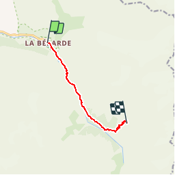
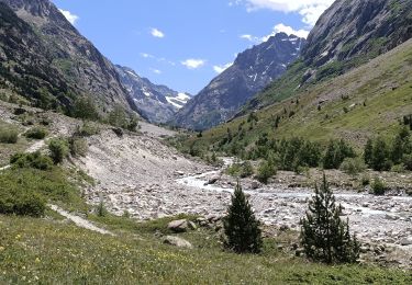
Trail Walking of 6.5 km to be discovered at Auvergne-Rhône-Alpes, Isère, Saint-Christophe-en-Oisans. This trail is proposed by tracegps.
Description
Départ de la Bérarde jusqu'au refuge du Carrelet (moyen de ce désaltérer), ensuite monter vers le Refuge du Temple des Ecrins. Tél refuge du Temple des Ecrins : 04/76790828 A la Bérarde, très beau gîte accueillant, "Le Champ de Pin", tél.:04/76795409
Positioning
Country:
France
Region :
Auvergne-Rhône-Alpes
Department/Province :
Isère
Municipality :
Saint-Christophe-en-Oisans
Location:
Unknown
Start:(Dec)
Start:(UTM)
286322 ; 4979044 (32T) N.
Comments
Trails nearby
![Trail Walking Saint-Christophe-en-Oisans - Oisans - Vallon des Etages - 6.5km 375m 2h20 - 2018 06 19 - public - Photo](https://media.geolcdn.com/t/375/260/ext.jpg?maxdim=2&url=https%3A%2F%2Fservices.sitytrail.com%2FGeolivesWS%2FDownloadMedia.ashx%3FTrailID%3D999391%26Media%3Dfix__20180619093050.jpg)
![Walking Walking](https://static1.geolcdn.com/sitytour/trail-icons/101.png)
Oisans - Vallon des Etages - 6.5km 375m 2h20 - 2018 06 19 - public
Walking
Medium
Saint-Christophe-en-Oisans,
Auvergne-Rhône-Alpes,
Isère,
France
![](/images/other/stat-length.png)
6.3 km | 11.2 km-effort
3h 20min
![](https://static1.geolcdn.com/siteimages/upload/files/16400158638029165_repeat_loop_refresh_sync_direction_icon.png)
Yes
![Trail Walking Saint-Christophe-en-Oisans - Oisans - La Bérarde Chatelleret - 11km 400m 3h25 - 2018 06 22 - public - Photo](https://media.geolcdn.com/t/375/260/ext.jpg?maxdim=2&url=https%3A%2F%2Fservices.sitytrail.com%2FGeolivesWS%2FDownloadMedia.ashx%3FTrailID%3D999336%26Media%3Dfix__20180622150554.jpg)
![Walking Walking](https://static1.geolcdn.com/sitytour/trail-icons/101.png)
Oisans - La Bérarde Chatelleret - 11km 400m 3h25 - 2018 06 22 - public
Walking
Medium
Saint-Christophe-en-Oisans,
Auvergne-Rhône-Alpes,
Isère,
France
![](/images/other/stat-length.png)
10.8 km | 16 km-effort
5h 30min
![](https://static1.geolcdn.com/siteimages/upload/files/16400158638029165_repeat_loop_refresh_sync_direction_icon.png)
Yes
![Trail Walking Saint-Christophe-en-Oisans - Oisans - Vénéon - Les Etages - Photo](https://media.geolcdn.com/t/375/260/ext.jpg?maxdim=2&url=https%3A%2F%2Fservices.sitytrail.com%2FGeolivesWS%2FDownloadMedia.ashx%3FTrailID%3D440121%26Media%3Dfix__20150625110049.jpg)
![Walking Walking](https://static1.geolcdn.com/sitytour/trail-icons/101.png)
Oisans - Vénéon - Les Etages
Walking
Easy
Saint-Christophe-en-Oisans,
Auvergne-Rhône-Alpes,
Isère,
France
![](/images/other/stat-length.png)
5.2 km | 7.6 km-effort
3h 15min
![](https://static1.geolcdn.com/siteimages/upload/files/16400158638029165_repeat_loop_refresh_sync_direction_icon.png)
Yes
![Trail Walking Saint-Christophe-en-Oisans - Oisans - Vénéon - La Bérarde - Le Chatelleret - Photo](https://media.geolcdn.com/t/375/260/ext.jpg?maxdim=2&url=https%3A%2F%2Fservices.sitytrail.com%2FGeolivesWS%2FDownloadMedia.ashx%3FTrailID%3D436077%26Media%3Dfix__20150620162005.jpg)
![Walking Walking](https://static1.geolcdn.com/sitytour/trail-icons/101.png)
Oisans - Vénéon - La Bérarde - Le Chatelleret
Walking
Medium
Saint-Christophe-en-Oisans,
Auvergne-Rhône-Alpes,
Isère,
France
![](/images/other/stat-length.png)
7.9 km | 10.8 km-effort
2h 50min
![](https://static1.geolcdn.com/siteimages/upload/files/16400158638029165_repeat_loop_refresh_sync_direction_icon.png)
Yes
![Trail Walking Saint-Christophe-en-Oisans - Oisans La Bérarde Vallée du Vénéon - Photo](https://media.geolcdn.com/t/375/260/ext.jpg?maxdim=2&url=https%3A%2F%2Fservices.sitytrail.com%2FGeolivesWS%2FDownloadMedia.ashx%3FTrailID%3D311048%26Media%3Dfix__20140608163517.jpg)
![Walking Walking](https://static1.geolcdn.com/sitytour/trail-icons/101.png)
Oisans La Bérarde Vallée du Vénéon
Walking
Medium
Saint-Christophe-en-Oisans,
Auvergne-Rhône-Alpes,
Isère,
France
![](/images/other/stat-length.png)
13.4 km | 18.5 km-effort
4h 1min
![](https://static1.geolcdn.com/siteimages/upload/files/16400158638029165_repeat_loop_refresh_sync_direction_icon.png)
Yes
![Trail Walking Saint-Christophe-en-Oisans - Cornes de Pié Bérarde - Photo](https://media.geolcdn.com/t/375/260/b365defd-9ad4-4aa5-a793-661817e0b806.jpg&format=jpg&maxdim=2)
![Walking Walking](https://static1.geolcdn.com/sitytour/trail-icons/101.png)
Cornes de Pié Bérarde
Walking
Very difficult
Saint-Christophe-en-Oisans,
Auvergne-Rhône-Alpes,
Isère,
France
![](/images/other/stat-length.png)
9.8 km | 27 km-effort
6h 7min
![](https://static1.geolcdn.com/siteimages/upload/files/16400158638029165_repeat_loop_refresh_sync_direction_icon.png)
Yes
![Trail Walking Saint-Christophe-en-Oisans - Rando depart du refuge du Carrelet et arrivée à La Berarde - Photo](https://media.geolcdn.com/t/375/260/ba3f2593-4b51-48ac-977d-c1aae9a6266f.jpg&format=jpg&maxdim=2)
![Walking Walking](https://static1.geolcdn.com/sitytour/trail-icons/101.png)
Rando depart du refuge du Carrelet et arrivée à La Berarde
Walking
Easy
Saint-Christophe-en-Oisans,
Auvergne-Rhône-Alpes,
Isère,
France
![](/images/other/stat-length.png)
4.4 km | 5.3 km-effort
1h 10min
![](https://static1.geolcdn.com/siteimages/upload/files/16400158638029165_repeat_loop_refresh_sync_direction_icon.png)
No
![Trail Walking Saint-Christophe-en-Oisans - Malraux Refuge du Chateleret - Photo](https://media.geolcdn.com/t/375/260/ext.jpg?maxdim=2&url=https%3A%2F%2Fservices.sitytrail.com%2FGeolivesWS%2FDownloadMedia.ashx%3FTrailID%3D1034336%26Media%3D20180904143743.jpg)
![Walking Walking](https://static1.geolcdn.com/sitytour/trail-icons/101.png)
Malraux Refuge du Chateleret
Walking
Easy
Saint-Christophe-en-Oisans,
Auvergne-Rhône-Alpes,
Isère,
France
![](/images/other/stat-length.png)
12.1 km | 19.4 km-effort
5h 26min
![](https://static1.geolcdn.com/siteimages/upload/files/16400158638029165_repeat_loop_refresh_sync_direction_icon.png)
Yes
![Trail Walking Saint-Christophe-en-Oisans - REFUGE DE CHATELLERET depuis LA BERARDE-07-09-2016 - Photo](https://media.geolcdn.com/t/375/260/ext.jpg?maxdim=2&url=https%3A%2F%2Fservices.sitytrail.com%2FGeolivesWS%2FDownloadMedia.ashx%3FTrailID%3D630354%26Media%3D20160907160722.jpg)
![Walking Walking](https://static1.geolcdn.com/sitytour/trail-icons/101.png)
REFUGE DE CHATELLERET depuis LA BERARDE-07-09-2016
Walking
Easy
Saint-Christophe-en-Oisans,
Auvergne-Rhône-Alpes,
Isère,
France
![](/images/other/stat-length.png)
14.9 km | 25 km-effort
6h 30min
![](https://static1.geolcdn.com/siteimages/upload/files/16400158638029165_repeat_loop_refresh_sync_direction_icon.png)
Yes