![](/images/other/stat-length.png)
![Trail Mountain bike Colomars - Grande Traversée des PréAlpes à VTT : Carros le Neuf - Nice - Photo](https://media.geolcdn.com/t/1900/400/ext.pjpeg?maxdim=2&url=https%3A%2F%2Fservices.sitytrail.com%2FGeolivesWS%2FDownloadMedia.ashx%3FTrailID%3D104791%26Media%3D8258_3.jpg)
Grande Traversée des PréAlpes à VTT : Carros le Neuf - Nice
tracegps
User
![Length](/images/other/stat-length.png)
![Max alt](https://static1.geolcdn.com/siteimages/upload/files/1508320355ic_sort_altitude_max_24dp.png)
![Uphill gradient](https://static1.geolcdn.com/siteimages/upload/files/1508320355ic_sort_den_pos_24dp.png)
![Km-Effort](/images/other/stat-length.png)
![Min alt](https://static1.geolcdn.com/siteimages/upload/files/1508320355ic_sort_altitude_min_24dp.png)
![Downhill gradient](https://static1.geolcdn.com/siteimages/upload/files/1508320355ic_sort_den_neg_24dp.png)
![Boucle](https://static1.geolcdn.com/siteimages/upload/files/16400158638029165_repeat_loop_refresh_sync_direction_icon.png)
![Mountain bike](https://static1.geolcdn.com/sitytour/trail-icons/202.png)
4h00
Difficulty : Difficult
![Scan this QR Code to open this trail in the SityTrail application](https://capi.geolives.com/qq0zvz2zws4bq2lad0pu/sitytour/trails/104791/qr.png?size=200)
FREE GPS app for hiking
About
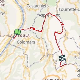
Trail Mountain bike of 13.8 km to be discovered at Provence-Alpes-Côte d'Azur, Maritime Alps, Colomars. This trail is proposed by tracegps.
Description
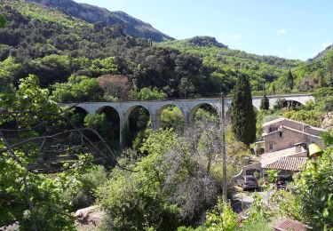
Grande Traversée des Préalpes, les Chemins du Soleil. Parcours officiel labellisé par la Fédération Française de Cyclisme. Cette fois, ça y est : le but est proche ! Le parcours vous mène en haut d’Aspremont , où vous pouvez d’ores et déjà humer l’odeur du sel marin sans pour autant voir la mer. Il faudra attendre de pousser votre vélo jusqu’au Mont Chauve pour la découvrir. Soufflez un grand coup et apprécier cette dernière descente bouclant l’itinéraire des Chemins du Soleil. Vous voilà engagé sur la longue rue piétonne au cœur de Nice qui s’en va finir le long des clapotis des vagues. Mesure de prudence : la descente sur Nice est secouante, et les pierres peuvent engendrer des crevaisons assez facilement. Il y a deux passages accidentés dont une marche importante qui ne se voie qu'au dernier moment. Consultez toutes les informations sur les hébergements et les services associés sur la fiche du tronçon.
Positioning
Comments
Trails nearby
![Trail Walking Saint-Jeannet - Baou de Saint-Jeannet - Photo](https://media.geolcdn.com/t/375/260/d4c22365-bd73-4ba1-a46d-47812961244f.jpg&format=jpg&maxdim=2)
![Walking Walking](https://static1.geolcdn.com/sitytour/trail-icons/101.png)
Walking
![](/images/other/stat-length.png)
![](https://static1.geolcdn.com/siteimages/upload/files/16400158638029165_repeat_loop_refresh_sync_direction_icon.png)
![Trail Walking Aspremont - Aspremont tour du Mont Chauve, montée au fort. - Photo](https://media.geolcdn.com/t/375/260/16e89ccd-b354-4ef1-b144-0fc157d8768e.jpg&format=jpg&maxdim=2)
![Walking Walking](https://static1.geolcdn.com/sitytour/trail-icons/101.png)
Walking
![](/images/other/stat-length.png)
![](https://static1.geolcdn.com/siteimages/upload/files/16400158638029165_repeat_loop_refresh_sync_direction_icon.png)
![Trail Walking Aspremont - Vallon OBSCUR aux portes de Nice - Photo](https://media.geolcdn.com/t/375/260/16c0b49c-5599-47d7-b53d-8d16968f7369.jpg&format=jpg&maxdim=2)
![Walking Walking](https://static1.geolcdn.com/sitytour/trail-icons/101.png)
Walking
![](/images/other/stat-length.png)
![](https://static1.geolcdn.com/siteimages/upload/files/16400158638029165_repeat_loop_refresh_sync_direction_icon.png)
![Trail On foot Gattières - Baou de la Gaude - Photo](https://media.geolcdn.com/t/375/260/ab686055-453b-4527-9610-4cf7a5679c21.jpeg&format=jpg&maxdim=2)
![On foot On foot](https://static1.geolcdn.com/sitytour/trail-icons/100.png)
On foot
![](/images/other/stat-length.png)
![](https://static1.geolcdn.com/siteimages/upload/files/16400158638029165_repeat_loop_refresh_sync_direction_icon.png)
![Trail On foot Carros - Les Balcons de Carros - Photo](https://media.geolcdn.com/t/375/260/a6a71bca-0b2f-4793-9dae-094488c13d6e.jpeg&format=jpg&maxdim=2)
![On foot On foot](https://static1.geolcdn.com/sitytour/trail-icons/100.png)
On foot
![](/images/other/stat-length.png)
![](https://static1.geolcdn.com/siteimages/upload/files/16400158638029165_repeat_loop_refresh_sync_direction_icon.png)
![Trail On foot Saint-Jeannet - Circuit du Castellet - Photo](https://media.geolcdn.com/t/375/260/afc23e4e-bd37-42a8-b455-4fba696582ad.jpeg&format=jpg&maxdim=2)
![On foot On foot](https://static1.geolcdn.com/sitytour/trail-icons/100.png)
On foot
![](/images/other/stat-length.png)
![](https://static1.geolcdn.com/siteimages/upload/files/16400158638029165_repeat_loop_refresh_sync_direction_icon.png)
![Trail Running Aspremont - Tour des Monts d'Aspremont 2007 - Photo](https://media.geolcdn.com/t/375/260/ext.jpg?maxdim=2&url=https%3A%2F%2Fstatic1.geolcdn.com%2Fsiteimages%2Fupload%2Ffiles%2F1524743154running.jpg)
![Running Running](https://static1.geolcdn.com/sitytour/trail-icons/103.png)
Running
![](/images/other/stat-length.png)
![](https://static1.geolcdn.com/siteimages/upload/files/16400158638029165_repeat_loop_refresh_sync_direction_icon.png)
![Trail Walking Saint-Jeannet - St Jeannet : les Baous janv 2025 - Photo](https://media.geolcdn.com/t/375/260/362b31cc-013f-4b2f-a360-d53c75d51365.jpg&format=jpg&maxdim=2)
![Walking Walking](https://static1.geolcdn.com/sitytour/trail-icons/101.png)
Walking
![](/images/other/stat-length.png)
![](https://static1.geolcdn.com/siteimages/upload/files/16400158638029165_repeat_loop_refresh_sync_direction_icon.png)
![Trail Walking Saint-Jeannet - Baous de la Gaude et de St Jeannet - Photo](https://media.geolcdn.com/t/375/260/3655e9c4-c4c4-495a-bc74-b57cc8e907b9.jpg&format=jpg&maxdim=2)
![Walking Walking](https://static1.geolcdn.com/sitytour/trail-icons/101.png)
Walking
![](/images/other/stat-length.png)
![](https://static1.geolcdn.com/siteimages/upload/files/16400158638029165_repeat_loop_refresh_sync_direction_icon.png)