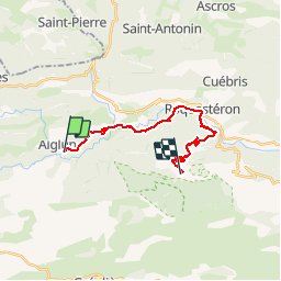
![](/images/other/stat-length.png)
![Trail Mountain bike Aiglun - Grande Traversée des PréAlpes à VTT : Aiglun - le Pous - Photo](https://media.geolcdn.com/t/1900/400/ext.pjpeg?maxdim=2&url=https%3A%2F%2Fservices.sitytrail.com%2FGeolivesWS%2FDownloadMedia.ashx%3FTrailID%3D104788%26Media%3D8255_2.jpg)
Grande Traversée des PréAlpes à VTT : Aiglun - le Pous
tracegps
User
![Length](/images/other/stat-length.png)
![Max alt](https://static1.geolcdn.com/siteimages/upload/files/1508320355ic_sort_altitude_max_24dp.png)
![Uphill gradient](https://static1.geolcdn.com/siteimages/upload/files/1508320355ic_sort_den_pos_24dp.png)
![Km-Effort](/images/other/stat-length.png)
![Min alt](https://static1.geolcdn.com/siteimages/upload/files/1508320355ic_sort_altitude_min_24dp.png)
![Downhill gradient](https://static1.geolcdn.com/siteimages/upload/files/1508320355ic_sort_den_neg_24dp.png)
![Boucle](https://static1.geolcdn.com/siteimages/upload/files/16400158638029165_repeat_loop_refresh_sync_direction_icon.png)
![Mountain bike](https://static1.geolcdn.com/sitytour/trail-icons/202.png)
2h15
Difficulty : Difficult
![Scan this QR Code to open this trail in the SityTrail application](https://capi.geolives.com/qq0zvz2zws4bq2lad0pu/sitytour/trails/104788/qr.png?size=200)
FREE GPS app for hiking
About
Trail Mountain bike of 18.7 km to be discovered at Provence-Alpes-Côte d'Azur, Maritime Alps, Aiglun. This trail is proposed by tracegps.
Description
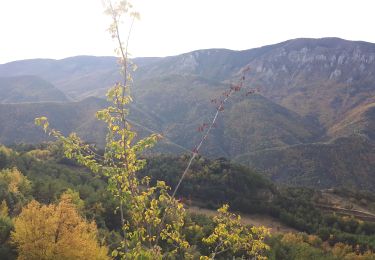
Grande Traversée des Préalpes, les Chemins du Soleil. Parcours officiel labellisé par la Fédération Française de Cyclisme. Mis à part la longue montée sur piste à partir de Roquesteron, ce tronçon regorge de sentiers très ludiques pour la pratique du VTT. Le parcours est plutôt ombragé sans grande difficulté malgré un court poussage après le pont de Sigale. A partir du 'Pous' deux options s'offrent à vous: 1. L'itinéraire normal en direction de Gilette 2. une variante difficile : la difficulté se situe sur la montée du Cheiron peu roulante. Il faut accepter de marcher à coté du vélo pour profiter des paysages et de plusieurs descentes particulièrement intéressantes pour VTTistes confirmés. Mesure de prudence : court poussage sur sentier après le pont de Sigale. Consultez toutes les informations sur les hébergements et les services associés sur la fiche du tronçon.
Positioning
Comments
Trails nearby
![Trail On foot Aiglun - Traversée de l'Estéron - Etape 3 - Photo](https://media.geolcdn.com/t/375/260/02747462-a559-4c53-baf5-cbd6ec427027.jpeg&format=jpg&maxdim=2)
![On foot On foot](https://static1.geolcdn.com/sitytour/trail-icons/100.png)
On foot
![](/images/other/stat-length.png)
![](https://static1.geolcdn.com/siteimages/upload/files/16400158638029165_repeat_loop_refresh_sync_direction_icon.png)
![Trail On foot Le Mas - Grand tour du haut Estéron - Etape 3 - Photo](https://media.geolcdn.com/t/375/260/849c76bc-5ee3-4c47-be26-b44412646500.jpeg&format=jpg&maxdim=2)
![On foot On foot](https://static1.geolcdn.com/sitytour/trail-icons/100.png)
On foot
![](/images/other/stat-length.png)
![](https://static1.geolcdn.com/siteimages/upload/files/16400158638029165_repeat_loop_refresh_sync_direction_icon.png)
![Trail On foot Sigale - Circuit de la Cacia - Photo](https://media.geolcdn.com/t/375/260/af8f583b-85f0-4a9c-891f-ad74e419fc87.jpeg&format=jpg&maxdim=2)
![On foot On foot](https://static1.geolcdn.com/sitytour/trail-icons/100.png)
On foot
![](/images/other/stat-length.png)
![](https://static1.geolcdn.com/siteimages/upload/files/16400158638029165_repeat_loop_refresh_sync_direction_icon.png)
![Trail On foot Gréolières - Cime du Cheiron - Photo](https://media.geolcdn.com/t/375/260/273aae50-c65a-44a2-8836-25bdf1d17610.jpeg&format=jpg&maxdim=2)
![On foot On foot](https://static1.geolcdn.com/sitytour/trail-icons/100.png)
On foot
![](/images/other/stat-length.png)
![](https://static1.geolcdn.com/siteimages/upload/files/16400158638029165_repeat_loop_refresh_sync_direction_icon.png)
![Trail On foot Le Mas - Montagne de Charamel - Photo](https://media.geolcdn.com/t/375/260/6284f77c-2485-44d3-926e-13cd2a0e2a2c.jpeg&format=jpg&maxdim=2)
![On foot On foot](https://static1.geolcdn.com/sitytour/trail-icons/100.png)
On foot
![](/images/other/stat-length.png)
![](https://static1.geolcdn.com/siteimages/upload/files/16400158638029165_repeat_loop_refresh_sync_direction_icon.png)
![Trail Walking Sigale - Cime CACCIA, SIGALE (06) - Photo](https://media.geolcdn.com/t/375/260/ext.jpg?maxdim=2&url=https%3A%2F%2Fservices.sitytrail.com%2FGeolivesWS%2FDownloadMedia.ashx%3FTrailID%3D497165%26Media%3Dfix__20151125111722.jpg)
![Walking Walking](https://static1.geolcdn.com/sitytour/trail-icons/101.png)
Walking
![](/images/other/stat-length.png)
![](https://static1.geolcdn.com/siteimages/upload/files/16400158638029165_repeat_loop_refresh_sync_direction_icon.png)
![Trail Walking Gréolières - Cretes du Cheiron - Photo](https://media.geolcdn.com/t/375/260/88c8f012-b9cc-414c-b278-7a06867d8cc1.jpg&format=jpg&maxdim=2)
![Walking Walking](https://static1.geolcdn.com/sitytour/trail-icons/101.png)
Walking
![](/images/other/stat-length.png)
![](https://static1.geolcdn.com/siteimages/upload/files/16400158638029165_repeat_loop_refresh_sync_direction_icon.png)
![Trail Walking Sigale - Sigale, Cime Caccia, Clue Riolan - Photo](https://media.geolcdn.com/t/375/260/84c34767-08d5-415b-9b57-1ef1e0464efe.jpg&format=jpg&maxdim=2)
![Walking Walking](https://static1.geolcdn.com/sitytour/trail-icons/101.png)
Walking
![](/images/other/stat-length.png)
![](https://static1.geolcdn.com/siteimages/upload/files/16400158638029165_repeat_loop_refresh_sync_direction_icon.png)
![Walking Walking](https://static1.geolcdn.com/sitytour/trail-icons/101.png)
Walking
![](/images/other/stat-length.png)
![](https://static1.geolcdn.com/siteimages/upload/files/16400158638029165_repeat_loop_refresh_sync_direction_icon.png)