![](/images/other/stat-length.png)
![Trail Mountain bike Soleilhas - Grande Traversée des PréAlpes à VTT : Stade de Neige de Vauplane - St Auban - Photo](https://media.geolcdn.com/t/1900/400/ext.pjpeg?maxdim=2&url=https%3A%2F%2Fservices.sitytrail.com%2FGeolivesWS%2FDownloadMedia.ashx%3FTrailID%3D104785%26Media%3D8252_2.jpg)
Grande Traversée des PréAlpes à VTT : Stade de Neige de Vauplane - St Auban
tracegps
User
![Length](/images/other/stat-length.png)
![Max alt](https://static1.geolcdn.com/siteimages/upload/files/1508320355ic_sort_altitude_max_24dp.png)
![Uphill gradient](https://static1.geolcdn.com/siteimages/upload/files/1508320355ic_sort_den_pos_24dp.png)
![Km-Effort](/images/other/stat-length.png)
![Min alt](https://static1.geolcdn.com/siteimages/upload/files/1508320355ic_sort_altitude_min_24dp.png)
![Downhill gradient](https://static1.geolcdn.com/siteimages/upload/files/1508320355ic_sort_den_neg_24dp.png)
![Boucle](https://static1.geolcdn.com/siteimages/upload/files/16400158638029165_repeat_loop_refresh_sync_direction_icon.png)
![Mountain bike](https://static1.geolcdn.com/sitytour/trail-icons/202.png)
2h30
Difficulty : Difficult
![Scan this QR Code to open this trail in the SityTrail application](https://capi.geolives.com/qq0zvz2zws4bq2lad0pu/sitytour/trails/104785/qr.png?size=200)
FREE GPS app for hiking
About
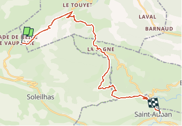
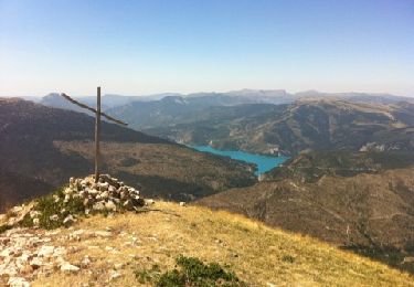
Trail Mountain bike of 16.4 km to be discovered at Provence-Alpes-Côte d'Azur, Alpes-de-Haute-Provence, Soleilhas. This trail is proposed by tracegps.
Description
Grande Traversée des Préalpes, les Chemins du Soleil. Parcours officiel labellisé par la Fédération Française de Cyclisme. Ce tronçon d'itinéraire a un profil globalement descendant. Quelques montées permettent de rejoindre des sentiers très ludiques. Le stade de neige de Vauplane offre un panorama exceptionnel sur les sommets du Mercantour. Ce paysage vous accompagne tout au long de la première descente sur sentier. Vous rejoignez la clue de St Auban en empruntant en grande majorité des sentiers agréables et non encore chaotiques comme vous les trouverez par la suite. Mesure de prudence : glissement de terrain avant le passage à Gué de la Bérrarde. Descente sur les Coulettes: quelques marches peuvent surprendre, présence de clôtures électriques (à refermer après votre passage). Consultez toutes les informations sur les hébergements et les services associés sur la fiche du tronçon.
Positioning
Comments
Trails nearby
![Trail Walking Soleilhas - Le Crémon depuis le Col St Barnabé - Photo](https://media.geolcdn.com/t/375/260/79a8d4bf-a2b3-4e87-a786-062fe2798e18.jpg&format=jpg&maxdim=2)
![Walking Walking](https://static1.geolcdn.com/sitytour/trail-icons/101.png)
Walking
![](/images/other/stat-length.png)
![](https://static1.geolcdn.com/siteimages/upload/files/16400158638029165_repeat_loop_refresh_sync_direction_icon.png)
![Trail Other activity Vergons - vergons par col de l iscle - Photo](https://media.geolcdn.com/t/375/260/ext.jpg?maxdim=2&url=https%3A%2F%2Fstatic1.geolcdn.com%2Fsiteimages%2Fupload%2Ffiles%2F1545311037marcheuse_200dpi.jpg)
![Other activity Other activity](https://static1.geolcdn.com/sitytour/trail-icons/900.png)
Other activity
![](/images/other/stat-length.png)
![](https://static1.geolcdn.com/siteimages/upload/files/16400158638029165_repeat_loop_refresh_sync_direction_icon.png)
![Trail Walking Soleilhas - Soleihas-LaSagne - Photo](https://media.geolcdn.com/t/375/260/af79a09e-f5aa-4733-8c13-044bef813c5f.jpg&format=jpg&maxdim=2)
![Walking Walking](https://static1.geolcdn.com/sitytour/trail-icons/101.png)
Walking
![](/images/other/stat-length.png)
![](https://static1.geolcdn.com/siteimages/upload/files/16400158638029165_repeat_loop_refresh_sync_direction_icon.png)
![Trail Walking Soleilhas - Crête de Bernarde - Photo](https://media.geolcdn.com/t/375/260/2a6e23d7-6399-46ad-806b-088e297c5970.jpg&format=jpg&maxdim=2)
![Walking Walking](https://static1.geolcdn.com/sitytour/trail-icons/101.png)
Walking
![](/images/other/stat-length.png)
![](https://static1.geolcdn.com/siteimages/upload/files/16400158638029165_repeat_loop_refresh_sync_direction_icon.png)
![Trail Walking Vergons - 2011-08-20 - 12h54m29 - Photo](https://media.geolcdn.com/t/375/260/ext.jpg?maxdim=2&url=https%3A%2F%2Fservices.sitytrail.com%2FGeolivesWS%2FDownloadMedia.ashx%3FTrailID%3D72377%26Media%3D20110820125415.jpg)
![Walking Walking](https://static1.geolcdn.com/sitytour/trail-icons/101.png)
Walking
![](/images/other/stat-length.png)
![](https://static1.geolcdn.com/siteimages/upload/files/16400158638029165_repeat_loop_refresh_sync_direction_icon.png)
![Trail Walking Vergons - 2011-08-20 - 12h54m29 - Photo](https://media.geolcdn.com/t/375/260/ext.jpg?maxdim=2&url=https%3A%2F%2Fservices.sitytrail.com%2FGeolivesWS%2FDownloadMedia.ashx%3FTrailID%3D72366%26Media%3D20110820125415.jpg)
![Walking Walking](https://static1.geolcdn.com/sitytour/trail-icons/101.png)
Walking
![](/images/other/stat-length.png)
![](https://static1.geolcdn.com/siteimages/upload/files/16400158638029165_repeat_loop_refresh_sync_direction_icon.png)
![Trail Walking Demandolx - Demandolx Le Cremon - Photo](https://media.geolcdn.com/t/375/260/ext.jpg?maxdim=2&url=https%3A%2F%2Fstatic1.geolcdn.com%2Fsiteimages%2Fupload%2Ffiles%2F1553511878bg_sport_marche.png)
![Walking Walking](https://static1.geolcdn.com/sitytour/trail-icons/101.png)
Walking
![](/images/other/stat-length.png)
![](https://static1.geolcdn.com/siteimages/upload/files/16400158638029165_repeat_loop_refresh_sync_direction_icon.png)
![Trail Walking Briançonnet - LaSagnesud - Photo](https://media.geolcdn.com/t/375/260/3cece64d-bfa3-47d3-8cfa-cee1bf841776.jpg&format=jpg&maxdim=2)
![Walking Walking](https://static1.geolcdn.com/sitytour/trail-icons/101.png)
Walking
![](/images/other/stat-length.png)
![](https://static1.geolcdn.com/siteimages/upload/files/16400158638029165_repeat_loop_refresh_sync_direction_icon.png)
![Trail Walking Briançonnet - laSagne25-07-24 - Photo](https://media.geolcdn.com/t/375/260/e49a3de8-c7ae-4493-b2ef-07b68fa7068c.jpg&format=jpg&maxdim=2)
![Walking Walking](https://static1.geolcdn.com/sitytour/trail-icons/101.png)
Walking
![](/images/other/stat-length.png)
![](https://static1.geolcdn.com/siteimages/upload/files/16400158638029165_repeat_loop_refresh_sync_direction_icon.png)