Trail Running Saint-Zacharie - Sainte Baume - Vedi - Photo
 tracegps
tracegps

User

© OpenStreetMap contributors
Length
Length
11 km
Max alt
Max alt
669 m
Uphill gradient
Uphill gradient
335 m
Km-Effort
Km-Effort  
15.4 km
Min alt
Min alt
373 m
Downhill gradient
Downhill gradient
335 m
Boucle
Boucle
Yes
Creation date :
2014-12-10 00:00:00.0
Updated on :
2014-12-10 00:00:00.0

(0 Reviews)

Running
Running
1h25
Difficulty : Difficult

Scan this QR Code to open this trail in the SityTrail application

FREE GPS app for hiking

Logo SityTrail SityTrail

IGN / Geographical institutes

Download SityTrail from the App Store Download SityTrail from Google Play

Logo SityTrail SityTrail World

The world is yours!

Download SityTrail from the App Store Download SityTrail from Google Play Download SityTrail on Huawei AppGallery

About

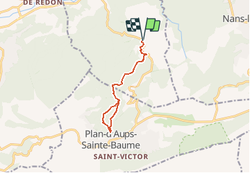
Trail Running of 11 km to be discovered at Provence-Alpes-Côte d'Azur, Var, Saint-Zacharie. This trail is proposed by tracegps.

Description

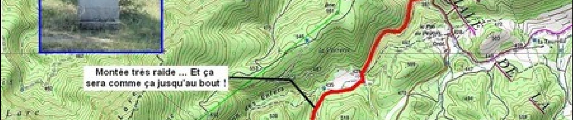
En combinant cet itinéraire avec le circuit 8107 on a un bon petit parcours VTT … A vos baskets ou à vos pédales, vous avez le choix ! Choisissez l'un, choisissez l'autre, de toute manière ça va monter, et après ça va descendre … Bonne sortie !

Elevation profile

Photos

Positioning

Country:
France
Region :
Provence-Alpes-Côte d'Azur
Department/Province :
Var
Municipality :
Saint-Zacharie
Location:
Unknown
Start:(UTM)
721277 ; 4804977 (31T) N.

Trails nearby

Trail Walking Plan-d'Aups-Sainte-Baume - Sainte Baume 8,5 km - Photo
Walking
GUIDE
rvapeldo

Walking

Medium
(1)
Plan-d'Aups-Sainte-Baume, Provence-Alpes-Côte d'Azur, Var, France
8.4 km | 15.5 km-effort
4h 38min
Yes
Trail Walking Plan-d'Aups-Sainte-Baume - SityTrail - Sentier merveilleux - La Ste baume - Le Plan d'aups  - Photo
Walking
GUIDE
affinetataille

Walking

Medium
(1)
Plan-d'Aups-Sainte-Baume, Provence-Alpes-Côte d'Azur, Var, France
15 km | 23 km-effort
6h 0min
Yes
Trail Walking Plan-d'Aups-Sainte-Baume - Crêts de la Ste Baume - Photo
Walking
tracegps

Walking

Medium
(2)
Plan-d'Aups-Sainte-Baume, Provence-Alpes-Côte d'Azur, Var, France
15.4 km | 23 km-effort
5h 0min
Yes
Trail Walking Plan-d'Aups-Sainte-Baume - Du Col du Saint-Pilon au Pas de l'Aï, Sainte Baume - Photo
Walking
tracegps

Walking

Medium
(1)
Plan-d'Aups-Sainte-Baume, Provence-Alpes-Côte d'Azur, Var, France
13.1 km | 20 km-effort
5h 15min
Yes
Trail Walking Plan-d'Aups-Sainte-Baume - La Grotte aux oiseaux - Plan d'Aups  - Photo
Walking
tracegps

Walking

Medium
(1)
Plan-d'Aups-Sainte-Baume, Provence-Alpes-Côte d'Azur, Var, France
8.8 km | 12.5 km-effort
2h 30min
Yes
Trail On foot Plan-d'Aups-Sainte-Baume - Massif Sainte Baume et pas de l’Aï 15 km - Photo
On foot
GUIDE
rvapeldo

On foot

Medium
Plan-d'Aups-Sainte-Baume, Provence-Alpes-Côte d'Azur, Var, France
15 km | 22 km-effort
5h 0min
Yes
Trail Walking Plan-d'Aups-Sainte-Baume - Sainte Baume par le sentier Marcel d'Estruch - Photo
Walking
GUIDE
nadd73

Walking

Difficult
Plan-d'Aups-Sainte-Baume, Provence-Alpes-Côte d'Azur, Var, France
13.3 km | 23 km-effort
4h 40min
No
Trail Walking Plan-d'Aups-Sainte-Baume - Marcel estruche - Photo
Walking
GUIDE
Danielba

Walking

Difficult
Plan-d'Aups-Sainte-Baume, Provence-Alpes-Côte d'Azur, Var, France
10.4 km | 18.9 km-effort
8h 6min
No
Trail Walking Plan-d'Aups-Sainte-Baume - Pic de Bertagne - Grotte Betton - Le plan d'aups - Photo
Walking
GUIDE
affinetataille

Walking

Medium
Plan-d'Aups-Sainte-Baume, Provence-Alpes-Côte d'Azur, Var, France
9.9 km | 15.7 km-effort
3h 30min
Yes


Close
My subscriptions