![](/images/other/stat-length.png)
![Trail Cycle Alençon - Petit tour dans Alençon - Photo](https://media.geolcdn.com/t/1900/400/ext.pjpeg?maxdim=2&url=https%3A%2F%2Fstatic1.geolcdn.com%2Fsiteimages%2Fupload%2Ffiles%2F1524743154velo.jpg)
Petit tour dans Alençon
tracegps
User
![Length](/images/other/stat-length.png)
Length
14.6 km
![Max alt](https://static1.geolcdn.com/siteimages/upload/files/1508320355ic_sort_altitude_max_24dp.png)
Max alt
168 m
![Uphill gradient](https://static1.geolcdn.com/siteimages/upload/files/1508320355ic_sort_den_pos_24dp.png)
Uphill gradient
105 m
![Km-Effort](/images/other/stat-length.png)
Km-Effort
16 km
![Min alt](https://static1.geolcdn.com/siteimages/upload/files/1508320355ic_sort_altitude_min_24dp.png)
Min alt
127 m
![Downhill gradient](https://static1.geolcdn.com/siteimages/upload/files/1508320355ic_sort_den_neg_24dp.png)
Downhill gradient
105 m
![Boucle](https://static1.geolcdn.com/siteimages/upload/files/16400158638029165_repeat_loop_refresh_sync_direction_icon.png)
Boucle
Yes
Creation date :
2014-12-10 00:00:00.0
Updated on :
2014-12-10 00:00:00.0
![Cycle](https://static1.geolcdn.com/sitytour/trail-icons/200.png)
45m
Difficulty : Easy
![Scan this QR Code to open this trail in the SityTrail application](https://capi.geolives.com/qq0zvz2zws4bq2lad0pu/sitytour/trails/104733/qr.png?size=200)
FREE GPS app for hiking
About
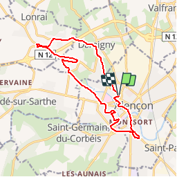
Trail Cycle of 14.6 km to be discovered at Normandy, Orne, Alençon. This trail is proposed by tracegps.
Description
Une petite boucle toute simple et sans prétention, juste de quoi se détendre les jambes après une journée de boulot. Passage par le Campus d'Alençon et le centre ville.
Positioning
Country:
France
Region :
Normandy
Department/Province :
Orne
Municipality :
Alençon
Location:
Unknown
Start:(Dec)
Start:(UTM)
284289 ; 5368726 (31U) N.
Comments
Trails nearby
![Trail Walking Arçonnay - Arconnay - Photo](https://media.geolcdn.com/t/375/260/ext.jpg?maxdim=2&url=https%3A%2F%2Fstatic1.geolcdn.com%2Fsiteimages%2Fupload%2Ffiles%2F1553511878bg_sport_marche.png)
![Walking Walking](https://static1.geolcdn.com/sitytour/trail-icons/101.png)
Arconnay
Walking
Medium
(1)
Arçonnay,
Pays de la Loire,
Sarthe,
France
![](/images/other/stat-length.png)
25 km | 28 km-effort
5h 28min
![](https://static1.geolcdn.com/siteimages/upload/files/16400158638029165_repeat_loop_refresh_sync_direction_icon.png)
Yes
![Trail Mountain bike Alençon - Montée à la croix de Médavy par route et descente par GR et chemins - Photo](https://media.geolcdn.com/t/375/260/ext.jpg?maxdim=2&url=https%3A%2F%2Fstatic1.geolcdn.com%2Fsiteimages%2Fupload%2Ffiles%2F1524743154velo.jpg)
![Mountain bike Mountain bike](https://static1.geolcdn.com/sitytour/trail-icons/202.png)
Montée à la croix de Médavy par route et descente par GR et chemins
Mountain bike
Easy
(1)
Alençon,
Normandy,
Orne,
France
![](/images/other/stat-length.png)
33 km | 40 km-effort
1h 34min
![](https://static1.geolcdn.com/siteimages/upload/files/16400158638029165_repeat_loop_refresh_sync_direction_icon.png)
Yes
![Trail Cycle Alençon - Véloscénie 3ème étape - Photo](https://media.geolcdn.com/t/375/260/ext.jpg?maxdim=2&url=https%3A%2F%2Fservices.sitytrail.com%2FGeolivesWS%2FDownloadMedia.ashx%3FTrailID%3D636896%26Media%3Dfix__20160913102128.jpg)
![Cycle Cycle](https://static1.geolcdn.com/sitytour/trail-icons/200.png)
![Trail Mountain bike Saint-Germain-du-Corbéis - Le bois de vaux - Photo](https://media.geolcdn.com/t/375/260/ext.jpg?maxdim=2&url=https%3A%2F%2Fstatic1.geolcdn.com%2Fsiteimages%2Fupload%2Ffiles%2F1524743154velo.jpg)
![Mountain bike Mountain bike](https://static1.geolcdn.com/sitytour/trail-icons/202.png)
Le bois de vaux
Mountain bike
Medium
(2)
Saint-Germain-du-Corbéis,
Normandy,
Orne,
France
![](/images/other/stat-length.png)
35 km | 39 km-effort
2h 16min
![](https://static1.geolcdn.com/siteimages/upload/files/16400158638029165_repeat_loop_refresh_sync_direction_icon.png)
Yes
![Trail Mountain bike Saint-Germain-du-Corbéis - chapelle St Evroult/château de Vaux - Photo](https://media.geolcdn.com/t/375/260/ext.jpg?maxdim=2&url=https%3A%2F%2Fmedia.geolcdn.com%2Ff%2Ffa51d126-bad4-43b5-a7f0-d58e2f351ae2.jpg)
![Mountain bike Mountain bike](https://static1.geolcdn.com/sitytour/trail-icons/202.png)
chapelle St Evroult/château de Vaux
Mountain bike
Medium
(1)
Saint-Germain-du-Corbéis,
Normandy,
Orne,
France
![](/images/other/stat-length.png)
34 km | 39 km-effort
2h 8min
![](https://static1.geolcdn.com/siteimages/upload/files/16400158638029165_repeat_loop_refresh_sync_direction_icon.png)
Yes
![Trail Cycle Alençon - Alençon, Héloup, Gesnes le Gandelin, Arçonnay, Alençon - Photo](https://media.geolcdn.com/t/375/260/ext.jpg?maxdim=2&url=https%3A%2F%2Fservices.sitytrail.com%2FGeolivesWS%2FDownloadMedia.ashx%3FTrailID%3D104750%26Media%3D8195_1.jpg)
![Cycle Cycle](https://static1.geolcdn.com/sitytour/trail-icons/200.png)
Alençon, Héloup, Gesnes le Gandelin, Arçonnay, Alençon
Cycle
Medium
Alençon,
Normandy,
Orne,
France
![](/images/other/stat-length.png)
30 km | 33 km-effort
1h 10min
![](https://static1.geolcdn.com/siteimages/upload/files/16400158638029165_repeat_loop_refresh_sync_direction_icon.png)
Yes
![Trail Bicycle tourism Alençon - La véloscénie - Alencon - Madré - Tronçon 1 - Photo](https://media.geolcdn.com/t/375/260/ext.jpg?maxdim=2&url=https%3A%2F%2Fstatic1.geolcdn.com%2Fsiteimages%2Fupload%2Ffiles%2F1524743154velo.jpg)
![Bicycle tourism Bicycle tourism](https://static1.geolcdn.com/sitytour/trail-icons/204.png)
La véloscénie - Alencon - Madré - Tronçon 1
Bicycle tourism
Very difficult
Alençon,
Normandy,
Orne,
France
![](/images/other/stat-length.png)
40 km | 45 km-effort
Unknown
![](https://static1.geolcdn.com/siteimages/upload/files/16400158638029165_repeat_loop_refresh_sync_direction_icon.png)
No
![Trail Bicycle tourism Alençon - Activity - Photo](https://media.geolcdn.com/t/375/260/ext.jpg?maxdim=2&url=https%3A%2F%2Fstatic1.geolcdn.com%2Fsiteimages%2Fupload%2Ffiles%2F1524743154velo.jpg)
![Bicycle tourism Bicycle tourism](https://static1.geolcdn.com/sitytour/trail-icons/204.png)
Activity
Bicycle tourism
Very difficult
Alençon,
Normandy,
Orne,
France
![](/images/other/stat-length.png)
155 km | 173 km-effort
Unknown
![](https://static1.geolcdn.com/siteimages/upload/files/16400158638029165_repeat_loop_refresh_sync_direction_icon.png)
No
![Trail Walking Saint-Paterne - Le Chevain - brullemail - Photo](https://media.geolcdn.com/t/375/260/ext.jpg?maxdim=2&url=https%3A%2F%2Fstatic1.geolcdn.com%2Fsiteimages%2Fupload%2Ffiles%2F1553511878bg_sport_marche.png)
![Walking Walking](https://static1.geolcdn.com/sitytour/trail-icons/101.png)
brullemail
Walking
Very difficult
Saint-Paterne - Le Chevain,
Pays de la Loire,
Sarthe,
France
![](/images/other/stat-length.png)
40 km | 46 km-effort
4h 24min
![](https://static1.geolcdn.com/siteimages/upload/files/16400158638029165_repeat_loop_refresh_sync_direction_icon.png)
No