![](/images/other/stat-length.png)
![Trail Walking Bligny-sur-Ouche - La Vierge Noire - Lusigny sur Ouche - Photo](https://media.geolcdn.com/t/1900/400/ext.pjpeg?maxdim=2&url=https%3A%2F%2Fservices.sitytrail.com%2FGeolivesWS%2FDownloadMedia.ashx%3FTrailID%3D104683%26Media%3D8086_1.jpg)
La Vierge Noire - Lusigny sur Ouche
tracegps
User
![Length](/images/other/stat-length.png)
![Max alt](https://static1.geolcdn.com/siteimages/upload/files/1508320355ic_sort_altitude_max_24dp.png)
![Uphill gradient](https://static1.geolcdn.com/siteimages/upload/files/1508320355ic_sort_den_pos_24dp.png)
![Km-Effort](/images/other/stat-length.png)
![Min alt](https://static1.geolcdn.com/siteimages/upload/files/1508320355ic_sort_altitude_min_24dp.png)
![Downhill gradient](https://static1.geolcdn.com/siteimages/upload/files/1508320355ic_sort_den_neg_24dp.png)
![Boucle](https://static1.geolcdn.com/siteimages/upload/files/16400158638029165_repeat_loop_refresh_sync_direction_icon.png)
![Walking](https://static1.geolcdn.com/sitytour/trail-icons/101.png)
4h00
Difficulty : Medium
![Scan this QR Code to open this trail in the SityTrail application](https://capi.geolives.com/qq0zvz2zws4bq2lad0pu/sitytour/trails/104683/qr.png?size=200)
FREE GPS app for hiking
About
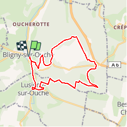
Trail Walking of 15.6 km to be discovered at Bourgogne-Franche-Comté, Côte-d'Or, Bligny-sur-Ouche. This trail is proposed by tracegps.
Description
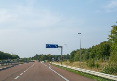
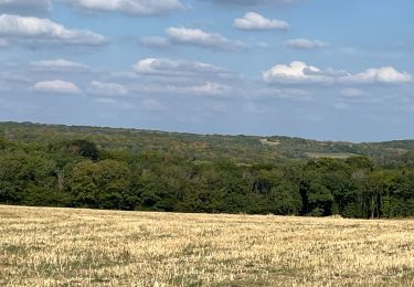
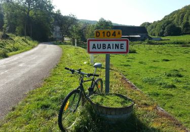
La Vierge Noire Distance 15,6 km, faible dénivelé (330 m), durée 4 heures. La traversée de la ferme "La Ruchotte" n'étant plus permise, nous avons contourné à l'est sur la route de Bessey-en-Chaume ; ce qui rallonge légèrement l'itinéraire officiel. Renseignements à l'Office de Tourisme de Bligny-sur-Ouche. Une randonnée du Club Alpin Français de l'Ouest Dijonnais. « Si tu veux aller un peu plus loin, avec le CAFOD tu feras des randonnées pas comme les autres» ! Avertissement : Les itinéraires mentionnés ici ne sont pas vérifiés (droit de passage, accidents de terrain, etc...). Par conséquent, il convient avant le départ de se renseigner sur la faisabilité du circuit envisagé.
Positioning
Comments
Trails nearby
![Trail On foot Bligny-sur-Ouche - Rail d'Antan 5 km - Photo](https://media.geolcdn.com/t/375/260/637ca046-a32c-4148-a597-8ba378120e94.jpeg&format=jpg&maxdim=2)
![On foot On foot](https://static1.geolcdn.com/sitytour/trail-icons/100.png)
On foot
![](/images/other/stat-length.png)
![](https://static1.geolcdn.com/siteimages/upload/files/16400158638029165_repeat_loop_refresh_sync_direction_icon.png)
![Trail On foot Bligny-sur-Ouche - Rail d'Antan 23 km - Photo](https://media.geolcdn.com/t/375/260/ad7c0928-387a-4851-9db7-b39d4b8213ed.jpeg&format=jpg&maxdim=2)
![On foot On foot](https://static1.geolcdn.com/sitytour/trail-icons/100.png)
On foot
![](/images/other/stat-length.png)
![](https://static1.geolcdn.com/siteimages/upload/files/16400158638029165_repeat_loop_refresh_sync_direction_icon.png)
![Trail On foot Bligny-sur-Ouche - Rail d'Antan 13 km - Photo](https://media.geolcdn.com/t/375/260/637ca046-a32c-4148-a597-8ba378120e94.jpeg&format=jpg&maxdim=2)
![On foot On foot](https://static1.geolcdn.com/sitytour/trail-icons/100.png)
On foot
![](/images/other/stat-length.png)
![](https://static1.geolcdn.com/siteimages/upload/files/16400158638029165_repeat_loop_refresh_sync_direction_icon.png)
![Trail On foot Bligny-sur-Ouche - De la Croix de Mission à la Vierge Noire - Photo](https://media.geolcdn.com/t/375/260/b329de3d-70a8-4983-83fa-da9c75f9d5eb.jpeg&format=jpg&maxdim=2)
![On foot On foot](https://static1.geolcdn.com/sitytour/trail-icons/100.png)
On foot
![](/images/other/stat-length.png)
![](https://static1.geolcdn.com/siteimages/upload/files/16400158638029165_repeat_loop_refresh_sync_direction_icon.png)
![Trail On foot Bligny-sur-Ouche - Chemin des Sources de l'Ouche (B) - Photo](https://media.geolcdn.com/t/375/260/637ca046-a32c-4148-a597-8ba378120e94.jpeg&format=jpg&maxdim=2)
![On foot On foot](https://static1.geolcdn.com/sitytour/trail-icons/100.png)
On foot
![](/images/other/stat-length.png)
![](https://static1.geolcdn.com/siteimages/upload/files/16400158638029165_repeat_loop_refresh_sync_direction_icon.png)
![Trail On foot Bligny-sur-Ouche - Chemin des Sources de l'Ouche (A) - Photo](https://media.geolcdn.com/t/375/260/637ca046-a32c-4148-a597-8ba378120e94.jpeg&format=jpg&maxdim=2)
![On foot On foot](https://static1.geolcdn.com/sitytour/trail-icons/100.png)
On foot
![](/images/other/stat-length.png)
![](https://static1.geolcdn.com/siteimages/upload/files/16400158638029165_repeat_loop_refresh_sync_direction_icon.png)
![Trail On foot Bligny-sur-Ouche - Chemin de la Montagne - Photo](https://media.geolcdn.com/t/375/260/637ca046-a32c-4148-a597-8ba378120e94.jpeg&format=jpg&maxdim=2)
![On foot On foot](https://static1.geolcdn.com/sitytour/trail-icons/100.png)
On foot
![](/images/other/stat-length.png)
![](https://static1.geolcdn.com/siteimages/upload/files/16400158638029165_repeat_loop_refresh_sync_direction_icon.png)
![Trail Walking Aubaine - Crepey - Photo](https://media.geolcdn.com/t/375/260/33bc5ff2-3522-4c54-bf0e-867878a671e4.jpg&format=jpg&maxdim=2)
![Walking Walking](https://static1.geolcdn.com/sitytour/trail-icons/101.png)
Walking
![](/images/other/stat-length.png)
![](https://static1.geolcdn.com/siteimages/upload/files/16400158638029165_repeat_loop_refresh_sync_direction_icon.png)
![Trail On foot Aubaine - De Combe en Combe - Photo](https://media.geolcdn.com/t/375/260/572ed625-a2ec-4ae3-841c-ffdf7cab621d.jpeg&format=jpg&maxdim=2)
![On foot On foot](https://static1.geolcdn.com/sitytour/trail-icons/100.png)
On foot
![](/images/other/stat-length.png)
![](https://static1.geolcdn.com/siteimages/upload/files/16400158638029165_repeat_loop_refresh_sync_direction_icon.png)
bof...