![](/images/other/stat-length.png)
![Trail Walking Nolay - Circuit Jean-Marc Boivin - Nolay - Photo](https://media.geolcdn.com/t/1900/400/ext.pjpeg?maxdim=2&url=https%3A%2F%2Fservices.sitytrail.com%2FGeolivesWS%2FDownloadMedia.ashx%3FTrailID%3D104678%26Media%3D8081_1.jpg)
Circuit Jean-Marc Boivin - Nolay
tracegps
User
![Length](/images/other/stat-length.png)
![Max alt](https://static1.geolcdn.com/siteimages/upload/files/1508320355ic_sort_altitude_max_24dp.png)
![Uphill gradient](https://static1.geolcdn.com/siteimages/upload/files/1508320355ic_sort_den_pos_24dp.png)
![Km-Effort](/images/other/stat-length.png)
![Min alt](https://static1.geolcdn.com/siteimages/upload/files/1508320355ic_sort_altitude_min_24dp.png)
![Downhill gradient](https://static1.geolcdn.com/siteimages/upload/files/1508320355ic_sort_den_neg_24dp.png)
![Boucle](https://static1.geolcdn.com/siteimages/upload/files/16400158638029165_repeat_loop_refresh_sync_direction_icon.png)
![Walking](https://static1.geolcdn.com/sitytour/trail-icons/101.png)
10h00
Difficulty : Very difficult
![Scan this QR Code to open this trail in the SityTrail application](https://capi.geolives.com/qq0zvz2zws4bq2lad0pu/sitytour/trails/104678/qr.png?size=200)
FREE GPS app for hiking
About
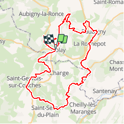
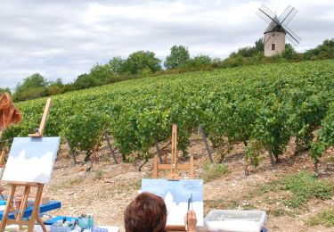
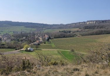
Trail Walking of 47 km to be discovered at Bourgogne-Franche-Comté, Côte-d'Or, Nolay. This trail is proposed by tracegps.
Description
Circuit Jean-Marc Boivin Départ et arrivée à la mairie de Nolay. Distance : 50 km. Dénivelé : 1500 m. Durée : 9 à 11 heures. Très beau circuit à mettre absolument à son palmarès. A faire sur 2 jours si l'on veut profiter pleinement des nombreux panoramas, sites et autres curiosités. Renseignements à l'Office de Tourisme de Nolay. Une randonnée du Club Alpin Français de l'Ouest Dijonnais. « Si tu veux aller un peu plus loin, avec le CAFOD tu feras des randonnées pas comme les autres» ! Avertissement : Les itinéraires mentionnés ici ne sont pas vérifiés (droit de passage, accidents de terrain, etc...). Par conséquent, il convient avant le départ de se renseigner sur la faisabilité du circuit envisagé.
Positioning
Comments
Trails nearby
![Trail Walking La Rochepot - SityTrail - 2208667 - la-rochepot-fontaine-dxorches-page-34 - Photo](https://media.geolcdn.com/t/375/260/ext.jpg?maxdim=2&url=https%3A%2F%2Fstatic1.geolcdn.com%2Fsiteimages%2Fupload%2Ffiles%2F1553511878bg_sport_marche.png)
![Walking Walking](https://static1.geolcdn.com/sitytour/trail-icons/101.png)
Walking
![](/images/other/stat-length.png)
![](https://static1.geolcdn.com/siteimages/upload/files/16400158638029165_repeat_loop_refresh_sync_direction_icon.png)
![Trail On foot Cormot-Vauchignon - Tour du Bout du Monde - Photo](https://media.geolcdn.com/t/375/260/d2f81624-c832-4428-84cb-c20336790b14.jpeg&format=jpg&maxdim=2)
![On foot On foot](https://static1.geolcdn.com/sitytour/trail-icons/100.png)
On foot
![](/images/other/stat-length.png)
![](https://static1.geolcdn.com/siteimages/upload/files/16400158638029165_repeat_loop_refresh_sync_direction_icon.png)
![Trail On foot La Rochepot - Sentier des Roches - Photo](https://media.geolcdn.com/t/375/260/b77770c8-6448-484a-9e88-f705666674c5.jpeg&format=jpg&maxdim=2)
![On foot On foot](https://static1.geolcdn.com/sitytour/trail-icons/100.png)
On foot
![](/images/other/stat-length.png)
![](https://static1.geolcdn.com/siteimages/upload/files/16400158638029165_repeat_loop_refresh_sync_direction_icon.png)
![Trail On foot Santenay - Circuit des Crêtes - Photo](https://media.geolcdn.com/t/375/260/547b2add-c27d-4fd8-89ec-29b77b06fbc9.jpeg&format=jpg&maxdim=2)
![On foot On foot](https://static1.geolcdn.com/sitytour/trail-icons/100.png)
On foot
![](/images/other/stat-length.png)
![](https://static1.geolcdn.com/siteimages/upload/files/16400158638029165_repeat_loop_refresh_sync_direction_icon.png)
![Trail Walking Saint-Sernin-du-Plain - Mazenay les deux monts page 17 - Photo](https://media.geolcdn.com/t/375/260/ext.jpg?maxdim=2&url=https%3A%2F%2Fstatic1.geolcdn.com%2Fsiteimages%2Fupload%2Ffiles%2F1553511878bg_sport_marche.png)
![Walking Walking](https://static1.geolcdn.com/sitytour/trail-icons/101.png)
Walking
![](/images/other/stat-length.png)
![](https://static1.geolcdn.com/siteimages/upload/files/16400158638029165_repeat_loop_refresh_sync_direction_icon.png)
![Trail Walking Baubigny - Sentier des roches - Photo](https://media.geolcdn.com/t/375/260/ext.jpg?maxdim=2&url=https%3A%2F%2Fstatic1.geolcdn.com%2Fsiteimages%2Fupload%2Ffiles%2F1553511878bg_sport_marche.png)
![Walking Walking](https://static1.geolcdn.com/sitytour/trail-icons/101.png)
Walking
![](/images/other/stat-length.png)
![](https://static1.geolcdn.com/siteimages/upload/files/16400158638029165_repeat_loop_refresh_sync_direction_icon.png)
![Trail Walking Nolay - Nolay - Photo](https://media.geolcdn.com/t/375/260/9282495d-1074-4443-ae92-d8927405f92a.jpg&format=jpg&maxdim=2)
![Walking Walking](https://static1.geolcdn.com/sitytour/trail-icons/101.png)
Walking
![](/images/other/stat-length.png)
![](https://static1.geolcdn.com/siteimages/upload/files/16400158638029165_repeat_loop_refresh_sync_direction_icon.png)
![Trail Walking Baubigny - 25-03-2022 Baubigny - Saint Romain - Photo](https://media.geolcdn.com/t/375/260/87c8896f-2725-40e9-98c6-75a240ae9d86.jpg&format=jpg&maxdim=2)
![Walking Walking](https://static1.geolcdn.com/sitytour/trail-icons/101.png)
Walking
![](/images/other/stat-length.png)
![](https://static1.geolcdn.com/siteimages/upload/files/16400158638029165_repeat_loop_refresh_sync_direction_icon.png)
![Trail Walking Cormot-Vauchignon - Vauchignon par de la le bout du monde page 9 - Photo](https://media.geolcdn.com/t/375/260/ext.jpg?maxdim=2&url=https%3A%2F%2Fstatic1.geolcdn.com%2Fsiteimages%2Fupload%2Ffiles%2F1553511878bg_sport_marche.png)
![Walking Walking](https://static1.geolcdn.com/sitytour/trail-icons/101.png)
Walking
![](/images/other/stat-length.png)
![](https://static1.geolcdn.com/siteimages/upload/files/16400158638029165_repeat_loop_refresh_sync_direction_icon.png)
très beau parcours, fait en intégralité en juillet en 09h30,
tres difficile