![](/images/other/stat-length.png)
![Trail Walking Fleurey-sur-Ouche - Le Marathon de Fleurey sur Ouche - Photo](https://media.geolcdn.com/t/1900/400/ext.pjpeg?maxdim=2&url=https%3A%2F%2Fservices.sitytrail.com%2FGeolivesWS%2FDownloadMedia.ashx%3FTrailID%3D104675%26Media%3D8078_1.jpg)
Le Marathon de Fleurey sur Ouche
tracegps
User
![Length](/images/other/stat-length.png)
![Max alt](https://static1.geolcdn.com/siteimages/upload/files/1508320355ic_sort_altitude_max_24dp.png)
![Uphill gradient](https://static1.geolcdn.com/siteimages/upload/files/1508320355ic_sort_den_pos_24dp.png)
![Km-Effort](/images/other/stat-length.png)
![Min alt](https://static1.geolcdn.com/siteimages/upload/files/1508320355ic_sort_altitude_min_24dp.png)
![Downhill gradient](https://static1.geolcdn.com/siteimages/upload/files/1508320355ic_sort_den_neg_24dp.png)
![Boucle](https://static1.geolcdn.com/siteimages/upload/files/16400158638029165_repeat_loop_refresh_sync_direction_icon.png)
![Walking](https://static1.geolcdn.com/sitytour/trail-icons/101.png)
10h00
Difficulty : Very difficult
![Scan this QR Code to open this trail in the SityTrail application](https://capi.geolives.com/qq0zvz2zws4bq2lad0pu/sitytour/trails/104675/qr.png?size=200)
FREE GPS app for hiking
About
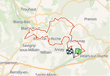
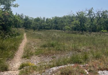
Trail Walking of 40 km to be discovered at Bourgogne-Franche-Comté, Côte-d'Or, Fleurey-sur-Ouche. This trail is proposed by tracegps.
Description
Le Marathon de Fleurey sur Ouche Départ face à l'église de Fleurey-sur-Ouche. L'appellation "marathon" tient à la longueur de cet itinéraire : 41 km avec 1000 m de dénivelé qui réclament entre 9 et 11 heures de randonnée. Environnement très varié. Beau parcours sportif à conseiller pour une mise en condition en vue de sorties de montagne. Une randonnée du Club Alpin Français de l'Ouest Dijonnais. « Si tu veux aller un peu plus loin, avec le CAFOD tu feras des randonnées pas comme les autres» ! Avertissement : Les itinéraires mentionnés ici ne sont pas vérifiés (droit de passage, accidents de terrain, etc...). Par conséquent, il convient avant le départ de se renseigner sur la faisabilité du circuit envisagé.
Positioning
Comments
Trails nearby
![Trail Walking Sainte-Marie-sur-Ouche - Pont de Pany - Photo](https://media.geolcdn.com/t/375/260/880c73c5-f480-4d0e-b6d7-7819f4768403.jpg&format=jpg&maxdim=2)
![Walking Walking](https://static1.geolcdn.com/sitytour/trail-icons/101.png)
Walking
![](/images/other/stat-length.png)
![](https://static1.geolcdn.com/siteimages/upload/files/16400158638029165_repeat_loop_refresh_sync_direction_icon.png)
![Trail Walking Velars-sur-Ouche - velars - Photo](https://media.geolcdn.com/t/375/260/f45fee3d-ded1-4c45-b841-446eb883a8de.jpg&format=jpg&maxdim=2)
![Walking Walking](https://static1.geolcdn.com/sitytour/trail-icons/101.png)
Walking
![](/images/other/stat-length.png)
![](https://static1.geolcdn.com/siteimages/upload/files/16400158638029165_repeat_loop_refresh_sync_direction_icon.png)
![Trail Walking Sainte-Marie-sur-Ouche - Belvédères sur la vallée de l'Ouche - Pont de Pany - Photo](https://media.geolcdn.com/t/375/260/ext.jpg?maxdim=2&url=https%3A%2F%2Fservices.sitytrail.com%2FGeolivesWS%2FDownloadMedia.ashx%3FTrailID%3D104685%26Media%3D8088_1.jpg)
![Walking Walking](https://static1.geolcdn.com/sitytour/trail-icons/101.png)
Walking
![](/images/other/stat-length.png)
![](https://static1.geolcdn.com/siteimages/upload/files/16400158638029165_repeat_loop_refresh_sync_direction_icon.png)
![Trail Walking Mâlain - Mâlain - Charmoy - Baulme le Roche - Photo](https://media.geolcdn.com/t/375/260/ext.jpg?maxdim=2&url=https%3A%2F%2Fservices.sitytrail.com%2FGeolivesWS%2FDownloadMedia.ashx%3FTrailID%3D104684%26Media%3D8087_1.jpg)
![Walking Walking](https://static1.geolcdn.com/sitytour/trail-icons/101.png)
Walking
![](/images/other/stat-length.png)
![](https://static1.geolcdn.com/siteimages/upload/files/16400158638029165_repeat_loop_refresh_sync_direction_icon.png)
![Trail Electric bike Sainte-Marie-sur-Ouche - Canal de Bourgogne_Etape 6 - Photo](https://media.geolcdn.com/t/375/260/ext.jpg?maxdim=2&url=https%3A%2F%2Fstatic1.geolcdn.com%2Fsiteimages%2Fupload%2Ffiles%2F1524743154velo.jpg)
![Electric bike Electric bike](https://static1.geolcdn.com/sitytour/trail-icons/205.png)
Electric bike
![](/images/other/stat-length.png)
![](https://static1.geolcdn.com/siteimages/upload/files/16400158638029165_repeat_loop_refresh_sync_direction_icon.png)
![Trail On foot Flavignerot - Du Naizou au Mont Afrique - Photo](https://media.geolcdn.com/t/375/260/37780069-2b1d-4f93-92c0-3e0d6f5857c8.jpeg&format=jpg&maxdim=2)
![On foot On foot](https://static1.geolcdn.com/sitytour/trail-icons/100.png)
On foot
![](/images/other/stat-length.png)
![](https://static1.geolcdn.com/siteimages/upload/files/16400158638029165_repeat_loop_refresh_sync_direction_icon.png)
![Trail On foot Fleurey-sur-Ouche - Sentier des Roches d'Orgères - Photo](https://media.geolcdn.com/t/375/260/22d3f48c-a3a5-4f31-ac6b-414d68092044.jpeg&format=jpg&maxdim=2)
![On foot On foot](https://static1.geolcdn.com/sitytour/trail-icons/100.png)
On foot
![](/images/other/stat-length.png)
![](https://static1.geolcdn.com/siteimages/upload/files/16400158638029165_repeat_loop_refresh_sync_direction_icon.png)
![Trail Walking Lantenay - Lantenay - Photo](https://media.geolcdn.com/t/375/260/3219c09e-e5a5-426c-903e-c4ce1812eb3a.jpg&format=jpg&maxdim=2)
![Walking Walking](https://static1.geolcdn.com/sitytour/trail-icons/101.png)
Walking
![](/images/other/stat-length.png)
![](https://static1.geolcdn.com/siteimages/upload/files/16400158638029165_repeat_loop_refresh_sync_direction_icon.png)
![Trail Walking Fleurey-sur-Ouche - Fleurey/lantenay - Photo](https://media.geolcdn.com/t/375/260/c40fbdf4-9587-4999-afb2-b7107038e144.jpg&format=jpg&maxdim=2)
![Walking Walking](https://static1.geolcdn.com/sitytour/trail-icons/101.png)
Walking
![](/images/other/stat-length.png)
![](https://static1.geolcdn.com/siteimages/upload/files/16400158638029165_repeat_loop_refresh_sync_direction_icon.png)
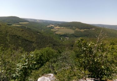
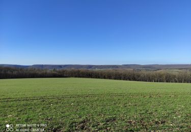
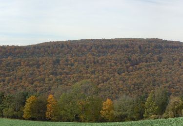
sportif et très bien calculé pour l'alternance des profils, ainsi que des trajectoires. À recommander pour un entraînement en progression, avec la motivation de paysages superbes .