Trail Mountain bike Soubran - Circuit des Bénissons - Soubran - Photo

Circuit des Bénissons - Soubran

 tracegps
tracegps

User

© OpenStreetMap contributors
Length
Length
29 km
Max alt
Max alt
109 m
Uphill gradient
Uphill gradient
383 m
Km-Effort
Km-Effort  
34 km
Min alt
Min alt
34 m
Downhill gradient
Downhill gradient
377 m
Boucle
Boucle
Yes
Creation date :
2014-12-10 00:00:00.0
Updated on :
2014-12-10 00:00:00.0

(0 Reviews)

Mountain bike
Mountain bike
2h00
Difficulty : Medium

Scan this QR Code to open this trail in the SityTrail application

FREE GPS app for hiking

Logo SityTrail SityTrail

IGN / Geographical institutes

Download SityTrail from the App Store Download SityTrail from Google Play

Logo SityTrail SityTrail World

The world is yours!

Download SityTrail from the App Store Download SityTrail from Google Play Download SityTrail on Huawei AppGallery

About

Trail Mountain bike of 29 km to be discovered at New Aquitaine, Charente-Maritime, Soubran. This trail is proposed by tracegps.

Description

Ce circuit est balisé par la Communauté de Communes de Haute-Saintonge. Il nous fait profiter du charme des campagnes et des forêts de pins de la Haute-Saintonge. Il culmine à plus de 100m d'altitude, ce qui est plutôt rare dans le département, et offre ainsi plusieurs panoramas. Il est possible de partir de la place de la mairie de Boisredon.

Elevation profile

Photos

Positioning

Country:
France
Region :
New Aquitaine
Department/Province :
Charente-Maritime
Municipality :
Soubran
Location:
Unknown
Start:(UTM)
693479 ; 5026487 (30T) N.

Trails nearby

Trail Walking Mirambeau - VOIE DE TOURS - 20ème étape : Mirambeau - Etauliers - St Martin-Lacsussade - Blaye - Lamarque - Photo
Walking
LEGUE

Walking

Very difficult
Mirambeau, New Aquitaine, Charente-Maritime, France
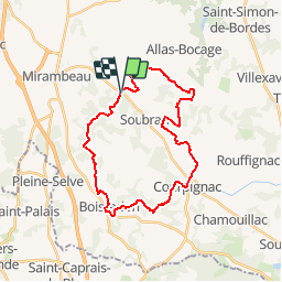
44 km | 49 km-effort
6h 54min
No
Trail Walking Mirambeau - Mirambeau petit Niort - Photo
Walking
jpland17800

Walking

Very difficult
Mirambeau, New Aquitaine, Charente-Maritime, France
24 km | 29 km-effort
3h 34min
No
Trail Walking Nieul-le-Virouil - Nieul le Virouil 12km - Photo
Walking
JACQUOU

Walking

Easy
Nieul-le-Virouil, New Aquitaine, Charente-Maritime, France
29 km | 33 km-effort
5h 55min
No
Trail Walking Mirambeau - mirambeau etauliers - Photo
Walking
Salers

Walking

Medium
Mirambeau, New Aquitaine, Charente-Maritime, France
25 km | 28 km-effort
4h 46min
No
Trail Walking Mirambeau - Camino 2-05-10 du 20/08/2019 - Photo
Walking
bene_dictus77

Walking

Very easy
Mirambeau, New Aquitaine, Charente-Maritime, France
21 km | 24 km-effort
5h 51min
No
Trail Walking Mirambeau - 028 Mirambeau Cartelegue - Photo
Walking
lucille

Walking

Very easy
Mirambeau, New Aquitaine, Charente-Maritime, France
27 km | 31 km-effort
6h 38min
No
Trail Walking Soubran - SOUBRAN 11 km - Photo
Walking
JACQUOU

Walking

Difficult
Soubran, New Aquitaine, Charente-Maritime, France
11.2 km | 13.7 km-effort
3h 7min
Yes
Trail Walking Allas-Bocage - Allas bocage avril 2024 ft 4 - Photo
Walking
0220599652

Walking

Easy
Allas-Bocage, New Aquitaine, Charente-Maritime, France
10.8 km | 12.2 km-effort
2h 47min
Yes
Trail Walking Soubran - Soubran ,9,5 km - Photo
Walking
JACQUOU

Walking

Easy
Soubran, New Aquitaine, Charente-Maritime, France
9.6 km | 11.2 km-effort
2h 18min
Yes


Close
My subscriptions