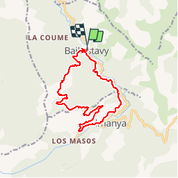
Trail Walking Baillestavy - 20180925 Baillestavy prat Mitja - Photo

20180925 Baillestavy prat Mitja

 ThonyM
ThonyM

User

© OpenStreetMap contributors
Length
Length
16.4 km
Max alt
Max alt
1447 m
Uphill gradient
Uphill gradient
962 m
Km-Effort
Km-Effort  
29 km
Min alt
Min alt
583 m
Downhill gradient
Downhill gradient
981 m
Boucle
Boucle
No
Creation date :
2019-01-15 16:48:47.924
Updated on :
2019-01-15 16:48:47.924

(0 Reviews)

Walking
Walking
4h52
Difficulty : Difficult

Scan this QR Code to open this trail in the SityTrail application

FREE GPS app for hiking

Logo SityTrail SityTrail

IGN / Geographical institutes

Download SityTrail from the App Store Download SityTrail from Google Play

Logo SityTrail SityTrail World

The world is yours!

Download SityTrail from the App Store Download SityTrail from Google Play Download SityTrail on Huawei AppGallery

About

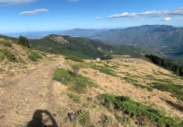
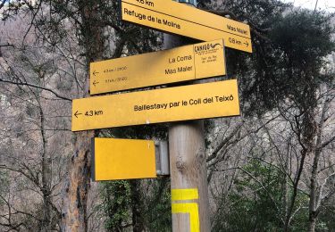
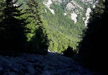
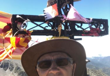
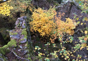
Trail Walking of 16.4 km to be discovered at Occitania, Pyrénées-Orientales, Baillestavy. This trail is proposed by ThonyM.

Description

Magnifique parcours. Matinée tout en montée.... bon pour de bons randonneurs

Elevation profile

Photos

Positioning

Country:
France
Region :
Occitania
Department/Province :
Pyrénées-Orientales
Municipality :
Baillestavy
Location:
Unknown
Start:(UTM)
461068 ; 4712529 (31T) N.

Trails nearby

Trail Walking Baillestavy - 20221127 Baillestavy- Valmanya - - Prat Mitja - Photo
Walking
ThonyM

Walking

Difficult
Baillestavy, Occitania, Pyrénées-Orientales, France
16.8 km | 30 km-effort
5h 2min
Yes
Trail Walking Taurinya - Jour 3 Pic du Canigou  - Photo
Walking
jacques delaporte

Walking

Difficult
Taurinya, Occitania, Pyrénées-Orientales, France
9.4 km | 16.1 km-effort
4h 29min
No
Trail Walking Taurinya - 2022 TRANSPYRÉNÉENNE : refuge les Mariales le Canigou - les Cortalets - Refuge  Bardera - Photo
Walking
LEGUE

Walking

Very difficult
Taurinya, Occitania, Pyrénées-Orientales, France
18.1 km | 27 km-effort
4h 5min
No
Trail Walking Baillestavy - 20220519 Ballestavy - Photo
Walking
ThonyM

Walking

Medium
Baillestavy, Occitania, Pyrénées-Orientales, France
12.6 km | 21 km-effort
3h 28min
Yes
Trail Walking Estoher - 20220227 Mas Maler- Mines de la Coume - Photo
Walking
ThonyM

Walking

Difficult
Estoher, Occitania, Pyrénées-Orientales, France
15.2 km | 30 km-effort
5h 35min
Yes
Trail Walking Valmanya - Los Masos Prat Cabrera - Photo
Walking
oscar1

Walking

Very difficult
Valmanya, Occitania, Pyrénées-Orientales, France
12.6 km | 23 km-effort
3h 37min
Yes
Trail Walking Valmanya - 20210705 Pic du Canigou par L’os Masos de Valmanya - Photo
Walking
ThonyM

Walking

Difficult
Valmanya, Occitania, Pyrénées-Orientales, France
23 km | 49 km-effort
7h 12min
Yes
Trail Walking Estoher - 20201025 tour du Jocavell depuis Mas Malet  - Photo
Walking
ThonyM

Walking

Medium
Estoher, Occitania, Pyrénées-Orientales, France
15.2 km | 30 km-effort
5h 55min
Yes
Trail Walking Valmanya - 20200815 Los Masos - Pinatell - Photo
Walking
ThonyM

Walking

Medium
Valmanya, Occitania, Pyrénées-Orientales, France
12.6 km | 23 km-effort
3h 47min
Yes


Close
My subscriptions