![](/images/other/stat-length.png)
![Trail Walking Tinchebray-Bocage - Petiteboucle à pied - La Vente Roulleau - Photo](https://media.geolcdn.com/t/1900/400/ext.pjpeg?maxdim=2&url=https%3A%2F%2Fstatic1.geolcdn.com%2Fsiteimages%2Fupload%2Ffiles%2F1553511878bg_sport_marche.png)
Petiteboucle à pied - La Vente Roulleau
tracegps
User
![Length](/images/other/stat-length.png)
Length
3.1 km
![Max alt](https://static1.geolcdn.com/siteimages/upload/files/1508320355ic_sort_altitude_max_24dp.png)
Max alt
222 m
![Uphill gradient](https://static1.geolcdn.com/siteimages/upload/files/1508320355ic_sort_den_pos_24dp.png)
Uphill gradient
91 m
![Km-Effort](/images/other/stat-length.png)
Km-Effort
4.4 km
![Min alt](https://static1.geolcdn.com/siteimages/upload/files/1508320355ic_sort_altitude_min_24dp.png)
Min alt
173 m
![Downhill gradient](https://static1.geolcdn.com/siteimages/upload/files/1508320355ic_sort_den_neg_24dp.png)
Downhill gradient
91 m
![Boucle](https://static1.geolcdn.com/siteimages/upload/files/16400158638029165_repeat_loop_refresh_sync_direction_icon.png)
Boucle
Yes
Creation date :
2014-12-10 00:00:00.0
Updated on :
2014-12-10 00:00:00.0
![Walking](https://static1.geolcdn.com/sitytour/trail-icons/101.png)
30m
Difficulty : Medium
![Scan this QR Code to open this trail in the SityTrail application](https://capi.geolives.com/qq0zvz2zws4bq2lad0pu/sitytour/trails/104614/qr.png?size=200)
FREE GPS app for hiking
About
Trail Walking of 3.1 km to be discovered at Normandy, Orne, Tinchebray-Bocage. This trail is proposed by tracegps.
Description
Malgré une faible distance, un dénivelé respectable. En gros, une descente au ruisseau qu'on longe avant de remonter à la Vente Roulleau.
Positioning
Country:
France
Region :
Normandy
Department/Province :
Orne
Municipality :
Tinchebray-Bocage
Location:
Beauchêne
Start:(Dec)
Start:(UTM)
665861 ; 5395936 (30U) N.
Comments
Trails nearby
![Trail Walking Tinchebray-Bocage - Chemin de l'Egrenne (n° 9) - Beauchêne - Photo](https://media.geolcdn.com/t/375/260/ext.jpg?maxdim=2&url=https%3A%2F%2Fservices.sitytrail.com%2FGeolivesWS%2FDownloadMedia.ashx%3FTrailID%3D172794%26Media%3D14224_5.jpg)
![Walking Walking](https://static1.geolcdn.com/sitytour/trail-icons/101.png)
Chemin de l'Egrenne (n° 9) - Beauchêne
Walking
Medium
(1)
Tinchebray-Bocage,
Normandy,
Orne,
France
![](/images/other/stat-length.png)
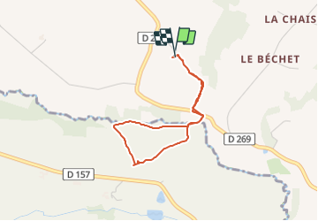
11.2 km | 14.6 km-effort
2h 49min
![](https://static1.geolcdn.com/siteimages/upload/files/16400158638029165_repeat_loop_refresh_sync_direction_icon.png)
Yes
![Trail On foot Tinchebray-Bocage - Le Ruslé - Photo](https://media.geolcdn.com/t/375/260/d803ed09-bbb7-4724-bfc1-ea340851ab65.jpeg&format=jpg&maxdim=2)
![On foot On foot](https://static1.geolcdn.com/sitytour/trail-icons/100.png)
![Trail Walking Tinchebray-Bocage - Michelot Moulin - Pays de Tinchebray - Photo](https://media.geolcdn.com/t/375/260/ext.jpg?maxdim=2&url=https%3A%2F%2Fservices.sitytrail.com%2FGeolivesWS%2FDownloadMedia.ashx%3FTrailID%3D111669%26Media%3D7907_2.jpg)
![Walking Walking](https://static1.geolcdn.com/sitytour/trail-icons/101.png)
Michelot Moulin - Pays de Tinchebray
Walking
Medium
Tinchebray-Bocage,
Normandy,
Orne,
France
![](/images/other/stat-length.png)
12.4 km | 15.4 km-effort
3h 0min
![](https://static1.geolcdn.com/siteimages/upload/files/16400158638029165_repeat_loop_refresh_sync_direction_icon.png)
Yes
![Trail On foot Tinchebray-Bocage - Chemin de l'Egrenne - Photo](https://media.geolcdn.com/t/375/260/ext.jpg?maxdim=2&url=https%3A%2F%2Fstatic1.geolcdn.com%2Fsiteimages%2Fupload%2Ffiles%2F1545311037marcheuse_200dpi.jpg)
![On foot On foot](https://static1.geolcdn.com/sitytour/trail-icons/100.png)
Chemin de l'Egrenne
On foot
Easy
Tinchebray-Bocage,
Normandy,
Orne,
France
![](/images/other/stat-length.png)
10.6 km | 14 km-effort
3h 10min
![](https://static1.geolcdn.com/siteimages/upload/files/16400158638029165_repeat_loop_refresh_sync_direction_icon.png)
Yes
![Trail Walking Tinchebray-Bocage - Le Ruslé (n° 11) - Yvrandes - Photo](https://media.geolcdn.com/t/375/260/ext.jpg?maxdim=2&url=https%3A%2F%2Fstatic1.geolcdn.com%2Fsiteimages%2Fupload%2Ffiles%2F1553511878bg_sport_marche.png)
![Walking Walking](https://static1.geolcdn.com/sitytour/trail-icons/101.png)
Le Ruslé (n° 11) - Yvrandes
Walking
Easy
Tinchebray-Bocage,
Normandy,
Orne,
France
![](/images/other/stat-length.png)
5.7 km | 7.3 km-effort
1h 30min
![](https://static1.geolcdn.com/siteimages/upload/files/16400158638029165_repeat_loop_refresh_sync_direction_icon.png)
Yes
![Trail Mountain bike Tinchebray-Bocage - Vente Roulleaux, Le Tertre, Lonlay l'Abbaye - Photo](https://media.geolcdn.com/t/375/260/ext.jpg?maxdim=2&url=https%3A%2F%2Fstatic1.geolcdn.com%2Fsiteimages%2Fupload%2Ffiles%2F1524743154velo.jpg)
![Mountain bike Mountain bike](https://static1.geolcdn.com/sitytour/trail-icons/202.png)
Vente Roulleaux, Le Tertre, Lonlay l'Abbaye
Mountain bike
Medium
Tinchebray-Bocage,
Normandy,
Orne,
France
![](/images/other/stat-length.png)
25 km | 32 km-effort
1h 55min
![](https://static1.geolcdn.com/siteimages/upload/files/16400158638029165_repeat_loop_refresh_sync_direction_icon.png)
No
![Trail Mountain bike Tinchebray-Bocage - Boucle autour de Ger et de ses éoliennes - Photo](https://media.geolcdn.com/t/375/260/ext.jpg?maxdim=2&url=https%3A%2F%2Fstatic1.geolcdn.com%2Fsiteimages%2Fupload%2Ffiles%2F1524743154velo.jpg)
![Mountain bike Mountain bike](https://static1.geolcdn.com/sitytour/trail-icons/202.png)
Boucle autour de Ger et de ses éoliennes
Mountain bike
Easy
Tinchebray-Bocage,
Normandy,
Orne,
France
![](/images/other/stat-length.png)
19.9 km | 25 km-effort
2h 30min
![](https://static1.geolcdn.com/siteimages/upload/files/16400158638029165_repeat_loop_refresh_sync_direction_icon.png)
Yes
![Trail Mountain bike Tinchebray-Bocage - Ger, Saint Jean des Bois, Yvrandes, Les Trois Cheminées - Photo](https://media.geolcdn.com/t/375/260/ext.jpg?maxdim=2&url=https%3A%2F%2Fstatic1.geolcdn.com%2Fsiteimages%2Fupload%2Ffiles%2F1524743154velo.jpg)
![Mountain bike Mountain bike](https://static1.geolcdn.com/sitytour/trail-icons/202.png)
Ger, Saint Jean des Bois, Yvrandes, Les Trois Cheminées
Mountain bike
Medium
Tinchebray-Bocage,
Normandy,
Orne,
France
![](/images/other/stat-length.png)
21 km | 27 km-effort
2h 30min
![](https://static1.geolcdn.com/siteimages/upload/files/16400158638029165_repeat_loop_refresh_sync_direction_icon.png)
Yes
![Trail Mountain bike Tinchebray-Bocage - Vente Roulleaux, Saint Jean des Bois, Le Fresne Poret - Photo](https://media.geolcdn.com/t/375/260/ext.jpg?maxdim=2&url=https%3A%2F%2Fstatic1.geolcdn.com%2Fsiteimages%2Fupload%2Ffiles%2F1524743154velo.jpg)
![Mountain bike Mountain bike](https://static1.geolcdn.com/sitytour/trail-icons/202.png)
Vente Roulleaux, Saint Jean des Bois, Le Fresne Poret
Mountain bike
Medium
Tinchebray-Bocage,
Normandy,
Orne,
France
![](/images/other/stat-length.png)
22 km | 27 km-effort
1h 49min
![](https://static1.geolcdn.com/siteimages/upload/files/16400158638029165_repeat_loop_refresh_sync_direction_icon.png)
Yes