![](/images/other/stat-length.png)
![Trail Mountain bike Échigey - Bourges (18) - Breurey lès Faverney (70) - Etape 5/6 - De Echigey à Seveux - Photo](https://media.geolcdn.com/t/1900/400/ext.pjpeg?maxdim=2&url=https%3A%2F%2Fservices.sitytrail.com%2FGeolivesWS%2FDownloadMedia.ashx%3FTrailID%3D104580%26Media%3D7971_4.jpg)
Bourges (18) - Breurey lès Faverney (70) - Etape 5/6 - De Echigey à Seveux
tracegps
User
![Length](/images/other/stat-length.png)
![Max alt](https://static1.geolcdn.com/siteimages/upload/files/1508320355ic_sort_altitude_max_24dp.png)
![Uphill gradient](https://static1.geolcdn.com/siteimages/upload/files/1508320355ic_sort_den_pos_24dp.png)
![Km-Effort](/images/other/stat-length.png)
![Min alt](https://static1.geolcdn.com/siteimages/upload/files/1508320355ic_sort_altitude_min_24dp.png)
![Downhill gradient](https://static1.geolcdn.com/siteimages/upload/files/1508320355ic_sort_den_neg_24dp.png)
![Boucle](https://static1.geolcdn.com/siteimages/upload/files/16400158638029165_repeat_loop_refresh_sync_direction_icon.png)
![Mountain bike](https://static1.geolcdn.com/sitytour/trail-icons/202.png)
8h30
Difficulty : Difficult
![Scan this QR Code to open this trail in the SityTrail application](https://capi.geolives.com/qq0zvz2zws4bq2lad0pu/sitytour/trails/104580/qr.png?size=200)
FREE GPS app for hiking
About
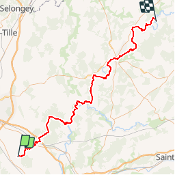
Trail Mountain bike of 92 km to be discovered at Bourgogne-Franche-Comté, Côte-d'Or, Échigey. This trail is proposed by tracegps.
Description
Traversées des très belles forêts de Longchamp et St Léger, pour rejoindre les rives de Saône, le canal de la Marne à la Saône, puis de nouveau les rives de Saône. A l'écluse n°13 de Savoyeux, la voie d'eau est souterraine. Vous passerez au dessus du tunnel pour arriver à Seveux, chambre d'hôtes, rue du Paquis, terme de cette 5ème étape. Faire le bon choix (gauche ou droit) de la rive de Saône à prendre, pour éviter les kilomètres supplémentaires. -Rive gauche à Lamarche. -Rive droite à Pontailler. -Traverser la Saône par la D39 à Apremont. -A Gray, rester rive gauche. -Rive droite à Quitteur jusqu'au tunnel. -Rive gauche après le tunnel jusqu'à Seveux.
Positioning
Comments
Trails nearby
![Trail sport Tart - TART le Haut 24 - Photo](https://media.geolcdn.com/t/375/260/ext.jpg?maxdim=2&url=https%3A%2F%2Fsecurestorage.geolives.com%2Fsitytour%2Ftrail-bg%2Fdefault.jpg)
sport
![](/images/other/stat-length.png)
![](https://static1.geolcdn.com/siteimages/upload/files/16400158638029165_repeat_loop_refresh_sync_direction_icon.png)
![Trail Cycle Tart - J2 Genlis Coussey - Photo](https://media.geolcdn.com/t/375/260/ext.jpg?maxdim=2&url=https%3A%2F%2Fstatic1.geolcdn.com%2Fsiteimages%2Fupload%2Ffiles%2F1524743154velo.jpg)
![Cycle Cycle](https://static1.geolcdn.com/sitytour/trail-icons/200.png)
Cycle
![](/images/other/stat-length.png)
![](https://static1.geolcdn.com/siteimages/upload/files/16400158638029165_repeat_loop_refresh_sync_direction_icon.png)
![Trail Walking Tart - Bois de Tart le Haut - Photo](https://media.geolcdn.com/t/375/260/ext.jpg?maxdim=2&url=https%3A%2F%2Fstatic1.geolcdn.com%2Fsiteimages%2Fupload%2Ffiles%2F1553511878bg_sport_marche.png)
![Walking Walking](https://static1.geolcdn.com/sitytour/trail-icons/101.png)
Walking
![](/images/other/stat-length.png)
![](https://static1.geolcdn.com/siteimages/upload/files/16400158638029165_repeat_loop_refresh_sync_direction_icon.png)