![](/images/other/stat-length.png)
![Trail Mountain bike Orbec - Rando Orbec 22 Km du 14 02 2010 - Photo](https://media.geolcdn.com/t/1900/400/ext.pjpeg?maxdim=2&url=https%3A%2F%2Fstatic1.geolcdn.com%2Fsiteimages%2Fupload%2Ffiles%2F1524743154velo.jpg)
Rando Orbec 22 Km du 14 02 2010
tracegps
User
![Length](/images/other/stat-length.png)
Length
22 km
![Max alt](https://static1.geolcdn.com/siteimages/upload/files/1508320355ic_sort_altitude_max_24dp.png)
Max alt
191 m
![Uphill gradient](https://static1.geolcdn.com/siteimages/upload/files/1508320355ic_sort_den_pos_24dp.png)
Uphill gradient
329 m
![Km-Effort](/images/other/stat-length.png)
Km-Effort
26 km
![Min alt](https://static1.geolcdn.com/siteimages/upload/files/1508320355ic_sort_altitude_min_24dp.png)
Min alt
109 m
![Downhill gradient](https://static1.geolcdn.com/siteimages/upload/files/1508320355ic_sort_den_neg_24dp.png)
Downhill gradient
327 m
![Boucle](https://static1.geolcdn.com/siteimages/upload/files/16400158638029165_repeat_loop_refresh_sync_direction_icon.png)
Boucle
Yes
Creation date :
2014-12-10 00:00:00.0
Updated on :
2014-12-10 00:00:00.0
![Mountain bike](https://static1.geolcdn.com/sitytour/trail-icons/202.png)
2h15
Difficulty : Medium
![Scan this QR Code to open this trail in the SityTrail application](https://capi.geolives.com/qq0zvz2zws4bq2lad0pu/sitytour/trails/104530/qr.png?size=200)
FREE GPS app for hiking
About
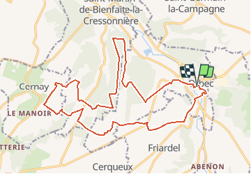
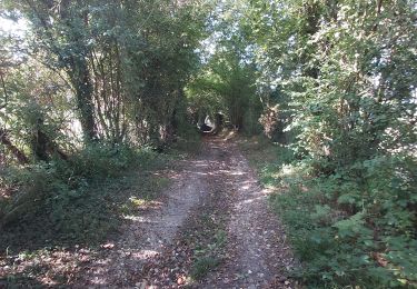
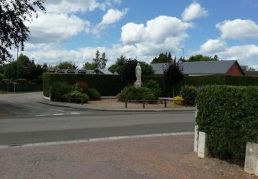
Trail Mountain bike of 22 km to be discovered at Normandy, Calvados, Orbec. This trail is proposed by tracegps.
Description
Randonnée VTT de 22 Kms au départ de la place de la mairie, parcours qui se déroule sur les communes de Saint Martin de Bienfaite, Cernay et Friardel. De beaux passages.
Positioning
Country:
France
Region :
Normandy
Department/Province :
Calvados
Municipality :
Orbec
Location:
Unknown
Start:(Dec)
Start:(UTM)
310333 ; 5433019 (31U) N.
Comments
Trails nearby
![Trail Cycle Saint-Germain-la-Campagne - Boucle des maisons de maîtres - St-Germain la Campagne - Photo](https://media.geolcdn.com/t/375/260/ext.jpg?maxdim=2&url=https%3A%2F%2Fservices.sitytrail.com%2FGeolivesWS%2FDownloadMedia.ashx%3FTrailID%3D110413%26Media%3D5884_1.jpg)
![Cycle Cycle](https://static1.geolcdn.com/sitytour/trail-icons/200.png)
Boucle des maisons de maîtres - St-Germain la Campagne
Cycle
Medium
(1)
Saint-Germain-la-Campagne,
Normandy,
Eure,
France
![](/images/other/stat-length.png)
16.3 km | 17.4 km-effort
1h 0min
![](https://static1.geolcdn.com/siteimages/upload/files/16400158638029165_repeat_loop_refresh_sync_direction_icon.png)
Yes
![Trail Walking Saint-Martin-de-Bienfaite-la-Cressonnière - saint Martin de bienfaite la cressonnière - Photo](https://media.geolcdn.com/t/375/260/dc2e5291-effa-4a8a-9672-fcdf7b22cd6e.jpg&format=jpg&maxdim=2)
![Walking Walking](https://static1.geolcdn.com/sitytour/trail-icons/101.png)
saint Martin de bienfaite la cressonnière
Walking
Medium
Saint-Martin-de-Bienfaite-la-Cressonnière,
Normandy,
Calvados,
France
![](/images/other/stat-length.png)
9.6 km | 12.2 km-effort
2h 52min
![](https://static1.geolcdn.com/siteimages/upload/files/16400158638029165_repeat_loop_refresh_sync_direction_icon.png)
Yes
![Trail Walking Livarot-Pays-d'Auge - Cerqueux - Photo](https://media.geolcdn.com/t/375/260/2f45acee-67f3-45b7-9c60-c3e7bdd88b3b.jpg&format=jpg&maxdim=2)
![Walking Walking](https://static1.geolcdn.com/sitytour/trail-icons/101.png)
Cerqueux
Walking
Easy
Livarot-Pays-d'Auge,
Normandy,
Calvados,
France
![](/images/other/stat-length.png)
8.2 km | 9.1 km-effort
2h 8min
![](https://static1.geolcdn.com/siteimages/upload/files/16400158638029165_repeat_loop_refresh_sync_direction_icon.png)
Yes
![Trail Walking Saint-Germain-la-Campagne - Chemin du Sabot bis - Photo](https://media.geolcdn.com/t/375/260/ext.jpg?maxdim=2&url=https%3A%2F%2Fstatic1.geolcdn.com%2Fsiteimages%2Fupload%2Ffiles%2F1553511878bg_sport_marche.png)
![Walking Walking](https://static1.geolcdn.com/sitytour/trail-icons/101.png)
Chemin du Sabot bis
Walking
Easy
(1)
Saint-Germain-la-Campagne,
Normandy,
Eure,
France
![](/images/other/stat-length.png)
9.8 km | 11.2 km-effort
2h 34min
![](https://static1.geolcdn.com/siteimages/upload/files/16400158638029165_repeat_loop_refresh_sync_direction_icon.png)
Yes
![Trail Walking Valorbiquet - Autour de l'Orbiquet - La Chapelle Yvon - Photo](https://media.geolcdn.com/t/375/260/ext.jpg?maxdim=2&url=https%3A%2F%2Fservices.sitytrail.com%2FGeolivesWS%2FDownloadMedia.ashx%3FTrailID%3D129765%26Media%3D13305_4.jpg)
![Walking Walking](https://static1.geolcdn.com/sitytour/trail-icons/101.png)
Autour de l'Orbiquet - La Chapelle Yvon
Walking
Medium
Valorbiquet,
Normandy,
Calvados,
France
![](/images/other/stat-length.png)
13.8 km | 18.2 km-effort
3h 0min
![](https://static1.geolcdn.com/siteimages/upload/files/16400158638029165_repeat_loop_refresh_sync_direction_icon.png)
Yes
![Trail Walking La Chapelle-Gauthier - La Mare Péreuse - La Chapelle-Gauthier - Photo](https://media.geolcdn.com/t/375/260/ext.jpg?maxdim=2&url=https%3A%2F%2Fservices.sitytrail.com%2FGeolivesWS%2FDownloadMedia.ashx%3FTrailID%3D110446%26Media%3D5936_3.jpg)
![Walking Walking](https://static1.geolcdn.com/sitytour/trail-icons/101.png)
La Mare Péreuse - La Chapelle-Gauthier
Walking
Medium
La Chapelle-Gauthier,
Normandy,
Eure,
France
![](/images/other/stat-length.png)
10.3 km | 11.9 km-effort
2h 45min
![](https://static1.geolcdn.com/siteimages/upload/files/16400158638029165_repeat_loop_refresh_sync_direction_icon.png)
Yes
![Trail Walking Livarot-Pays-d'Auge - Cerqueux (14) - Photo](https://media.geolcdn.com/t/375/260/fa66af0f-7d93-434d-88a9-997e464e8dc8.jpg&format=jpg&maxdim=2)
![Walking Walking](https://static1.geolcdn.com/sitytour/trail-icons/101.png)
Cerqueux (14)
Walking
Medium
Livarot-Pays-d'Auge,
Normandy,
Calvados,
France
![](/images/other/stat-length.png)
15.8 km | 18.1 km-effort
3h 43min
![](https://static1.geolcdn.com/siteimages/upload/files/16400158638029165_repeat_loop_refresh_sync_direction_icon.png)
Yes
![Trail Walking Valorbiquet - La Chapelle Yvon - Photo](https://media.geolcdn.com/t/375/260/81604d73-e81e-4ec8-83e6-c5dbf6eea144.jpg&format=jpg&maxdim=2)
![Walking Walking](https://static1.geolcdn.com/sitytour/trail-icons/101.png)
La Chapelle Yvon
Walking
Easy
Valorbiquet,
Normandy,
Calvados,
France
![](/images/other/stat-length.png)
13.4 km | 15.5 km-effort
2h 45min
![](https://static1.geolcdn.com/siteimages/upload/files/16400158638029165_repeat_loop_refresh_sync_direction_icon.png)
Yes
![Trail Walking Saint-Germain-la-Campagne - st Germain le campagne - Photo](https://media.geolcdn.com/t/375/260/f555ef23-b15b-473f-8d15-6db03996f0a3.jpg&format=jpg&maxdim=2)
![Walking Walking](https://static1.geolcdn.com/sitytour/trail-icons/101.png)
st Germain le campagne
Walking
Easy
Saint-Germain-la-Campagne,
Normandy,
Eure,
France
![](/images/other/stat-length.png)
8.3 km | 9.3 km-effort
1h 40min
![](https://static1.geolcdn.com/siteimages/upload/files/16400158638029165_repeat_loop_refresh_sync_direction_icon.png)
Yes