![](/images/other/stat-length.png)
![Trail Snowshoes Ramonchamp - Vosges en Raquettes : Ramonchamp, les 3 chalets - Photo](https://media.geolcdn.com/t/1900/400/ext.pjpeg?maxdim=2&url=https%3A%2F%2Fstatic1.geolcdn.com%2Fsiteimages%2Fupload%2Ffiles%2F1524743153raquette.jpg)
Vosges en Raquettes : Ramonchamp, les 3 chalets
tracegps
User
![Length](/images/other/stat-length.png)
![Max alt](https://static1.geolcdn.com/siteimages/upload/files/1508320355ic_sort_altitude_max_24dp.png)
![Uphill gradient](https://static1.geolcdn.com/siteimages/upload/files/1508320355ic_sort_den_pos_24dp.png)
![Km-Effort](/images/other/stat-length.png)
![Min alt](https://static1.geolcdn.com/siteimages/upload/files/1508320355ic_sort_altitude_min_24dp.png)
![Downhill gradient](https://static1.geolcdn.com/siteimages/upload/files/1508320355ic_sort_den_neg_24dp.png)
![Boucle](https://static1.geolcdn.com/siteimages/upload/files/16400158638029165_repeat_loop_refresh_sync_direction_icon.png)
![Snowshoes](https://static1.geolcdn.com/sitytour/trail-icons/504.png)
2h30
Difficulty : Difficult
![Scan this QR Code to open this trail in the SityTrail application](https://capi.geolives.com/qq0zvz2zws4bq2lad0pu/sitytour/trails/104526/qr.png?size=200)
FREE GPS app for hiking
About
Trail Snowshoes of 8.9 km to be discovered at Grand Est, Vosges, Ramonchamp. This trail is proposed by tracegps.
Description
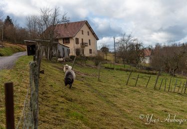
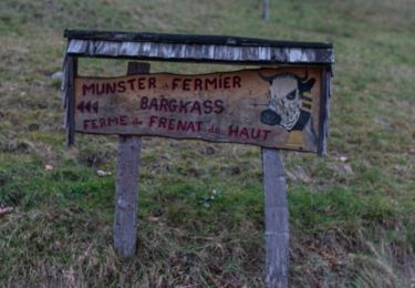
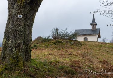
Pour rejoindre le départ, à Ramonchamp monter le col de Morbieux jusqu'à la limite du déneigement de la route, soit à l'auberge, soit sur le petit parking un peu plus haut au niveau de la dernière maison. Monter par la route puis prendre le chemin des pavés en rejoignant le grand chemin, continuer à monter à gauche (balisage vtt). Ensuite prendre à droite balisage rond rouge direction chalet de l'Aireu/ col de Morbieux. Au col redescendre la route à droite et prendre rapidement à gauche, toujours rond rouge, faire un petit crochet au chalet des Poncées, puis prendre direction la Flaconnière. Encore un petit détour jusqu'au chalet, revenir sur ses pas et descendre à gauche direction Salmon. Plus loin descendre à droite à l'envers du circuit vtt, puis et à gauche et rapidement à droite (balisage vtt) pour rejoindre la route. A la route descendre à gauche pour rejoindre le départ. La seule difficulté est la distance, 9.5 km pour 330 m de dénivelé. Circuit peu fréquenté.
Positioning
Comments
Trails nearby
![Trail Walking Le Ménil - Boucle au départ des chalets de la](https://media.geolcdn.com/t/375/260/a828a9f3-0482-4d5b-86c2-c919e4b59d9f.jpg&format=jpg&maxdim=2)
![Walking Walking](https://static1.geolcdn.com/sitytour/trail-icons/101.png)
Walking
![](/images/other/stat-length.png)
![](https://static1.geolcdn.com/siteimages/upload/files/16400158638029165_repeat_loop_refresh_sync_direction_icon.png)
![Trail On foot Fresse-sur-Moselle - Les ballons à l’horizon - Photo](https://media.geolcdn.com/t/375/260/30df9189-1183-47e3-a585-be073639a450.jpeg&format=jpg&maxdim=2)
![On foot On foot](https://static1.geolcdn.com/sitytour/trail-icons/100.png)
On foot
![](/images/other/stat-length.png)
![](https://static1.geolcdn.com/siteimages/upload/files/16400158638029165_repeat_loop_refresh_sync_direction_icon.png)
![Trail Walking Saulxures-sur-Moselotte - France Vosges saulxure sur Moselotte Etang des fées coteau du bambois 3,6km 22072019 - Photo](https://media.geolcdn.com/t/375/260/ext.jpg?maxdim=2&url=https%3A%2F%2Fstatic1.geolcdn.com%2Fsiteimages%2Fupload%2Ffiles%2F1553511878bg_sport_marche.png)
![Walking Walking](https://static1.geolcdn.com/sitytour/trail-icons/101.png)
Walking
![](/images/other/stat-length.png)
![](https://static1.geolcdn.com/siteimages/upload/files/16400158638029165_repeat_loop_refresh_sync_direction_icon.png)
![Trail Walking Ramonchamp - Tournée de 3 chalets - Photo](https://media.geolcdn.com/t/375/260/9772d619-fbbf-4858-9b6a-d813a318e1c1.jpeg&format=jpg&maxdim=2)
![Walking Walking](https://static1.geolcdn.com/sitytour/trail-icons/101.png)
Walking
![](/images/other/stat-length.png)
![](https://static1.geolcdn.com/siteimages/upload/files/16400158638029165_repeat_loop_refresh_sync_direction_icon.png)
![Trail On foot Saulxures-sur-Moselotte - Col du rhamné depuis cirque de grettery - Photo](https://media.geolcdn.com/t/375/260/ext.jpg?maxdim=2&url=https%3A%2F%2Fstatic1.geolcdn.com%2Fsiteimages%2Fupload%2Ffiles%2F1545311037marcheuse_200dpi.jpg)
![On foot On foot](https://static1.geolcdn.com/sitytour/trail-icons/100.png)
On foot
![](/images/other/stat-length.png)
![](https://static1.geolcdn.com/siteimages/upload/files/16400158638029165_repeat_loop_refresh_sync_direction_icon.png)
![Trail Walking Fresse-sur-Moselle - Croix de Fresse - Vosges - France - Photo](https://media.geolcdn.com/t/375/260/1bf27e15-8257-4a1e-ac29-4caf5b1917b2.jpg&format=jpg&maxdim=2)
![Walking Walking](https://static1.geolcdn.com/sitytour/trail-icons/101.png)
Walking
![](/images/other/stat-length.png)
![](https://static1.geolcdn.com/siteimages/upload/files/16400158638029165_repeat_loop_refresh_sync_direction_icon.png)
![Trail Walking Le Ménil - Grande boucle au départ des chalets de la Feigne sur de l'Eau - Photo](https://media.geolcdn.com/t/375/260/b2496837-76c8-4943-ba65-2ceef61b2aba.jpg&format=jpg&maxdim=2)
![Walking Walking](https://static1.geolcdn.com/sitytour/trail-icons/101.png)
Walking
![](/images/other/stat-length.png)
![](https://static1.geolcdn.com/siteimages/upload/files/16400158638029165_repeat_loop_refresh_sync_direction_icon.png)
![Trail Walking Le Ménil - Le Ménil - Balade des deux chapelles - Photo](https://media.geolcdn.com/t/375/260/f2cb1345-e29f-42ab-8823-412385488c99.jpeg&format=jpg&maxdim=2)
![Walking Walking](https://static1.geolcdn.com/sitytour/trail-icons/101.png)
Walking
![](/images/other/stat-length.png)
![](https://static1.geolcdn.com/siteimages/upload/files/16400158638029165_repeat_loop_refresh_sync_direction_icon.png)
![Trail Walking Le Ménil - Boucle de La Chapelle de la Pitié - Photo](https://media.geolcdn.com/t/375/260/ce3b81f6-783c-43cd-b17c-23cdf62ae867.jpeg&format=jpg&maxdim=2)
![Walking Walking](https://static1.geolcdn.com/sitytour/trail-icons/101.png)
Walking
![](/images/other/stat-length.png)
![](https://static1.geolcdn.com/siteimages/upload/files/16400158638029165_repeat_loop_refresh_sync_direction_icon.png)