![](/images/other/stat-length.png)
![Trail Mountain bike Creully sur Seulles - Rando Creully 40km - Photo](https://media.geolcdn.com/t/1900/400/ext.pjpeg?maxdim=2&url=https%3A%2F%2Fstatic1.geolcdn.com%2Fsiteimages%2Fupload%2Ffiles%2F1524743154velo.jpg)
Rando Creully 40km
tracegps
User
![Length](/images/other/stat-length.png)
Length
39 km
![Max alt](https://static1.geolcdn.com/siteimages/upload/files/1508320355ic_sort_altitude_max_24dp.png)
Max alt
62 m
![Uphill gradient](https://static1.geolcdn.com/siteimages/upload/files/1508320355ic_sort_den_pos_24dp.png)
Uphill gradient
383 m
![Km-Effort](/images/other/stat-length.png)
Km-Effort
44 km
![Min alt](https://static1.geolcdn.com/siteimages/upload/files/1508320355ic_sort_altitude_min_24dp.png)
Min alt
5 m
![Downhill gradient](https://static1.geolcdn.com/siteimages/upload/files/1508320355ic_sort_den_neg_24dp.png)
Downhill gradient
384 m
![Boucle](https://static1.geolcdn.com/siteimages/upload/files/16400158638029165_repeat_loop_refresh_sync_direction_icon.png)
Boucle
Yes
Creation date :
2014-12-10 00:00:00.0
Updated on :
2014-12-10 00:00:00.0
![Mountain bike](https://static1.geolcdn.com/sitytour/trail-icons/202.png)
2h30
Difficulty : Medium
![Scan this QR Code to open this trail in the SityTrail application](https://capi.geolives.com/qq0zvz2zws4bq2lad0pu/sitytour/trails/104458/qr.png?size=200)
FREE GPS app for hiking
About
Trail Mountain bike of 39 km to be discovered at Normandy, Calvados, Creully sur Seulles. This trail is proposed by tracegps.
Description
Rando de Creully 40km. Le parcours n'a rien de très technique mais la boue collante rend le circuit un peu moins facile!!!
Positioning
Country:
France
Region :
Normandy
Department/Province :
Calvados
Municipality :
Creully sur Seulles
Location:
Creully
Start:(Dec)
Start:(UTM)
679027 ; 5462226 (30U) N.
Comments
Trails nearby
![Trail On foot Le Fresne-Camilly - autours de Fresne-Camilly, Fontaine Henry - Photo](https://media.geolcdn.com/t/375/260/ext.jpg?maxdim=2&url=https%3A%2F%2Fstatic1.geolcdn.com%2Fsiteimages%2Fupload%2Ffiles%2F1545311037marcheuse_200dpi.jpg)
![On foot On foot](https://static1.geolcdn.com/sitytour/trail-icons/100.png)
autours de Fresne-Camilly, Fontaine Henry
On foot
Medium
(1)
Le Fresne-Camilly,
Normandy,
Calvados,
France
![](/images/other/stat-length.png)
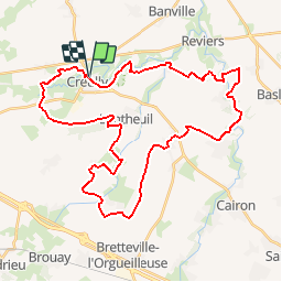
18.8 km | 21 km-effort
4h 50min
![](https://static1.geolcdn.com/siteimages/upload/files/16400158638029165_repeat_loop_refresh_sync_direction_icon.png)
Yes
![Trail Mountain bike Creully sur Seulles - creuilly- asnelles - Photo](https://media.geolcdn.com/t/375/260/ext.jpg?maxdim=2&url=https%3A%2F%2Fservices.sitytrail.com%2FGeolivesWS%2FDownloadMedia.ashx%3FTrailID%3D211399%26Media%3Dfix__20130809113151.jpg)
![Mountain bike Mountain bike](https://static1.geolcdn.com/sitytour/trail-icons/202.png)
creuilly- asnelles
Mountain bike
Medium
Creully sur Seulles,
Normandy,
Calvados,
France
![](/images/other/stat-length.png)
44 km | 49 km-effort
2h 42min
![](https://static1.geolcdn.com/siteimages/upload/files/16400158638029165_repeat_loop_refresh_sync_direction_icon.png)
Yes
![Trail Mountain bike Vienne-en-Bessin - balade ver sur mer - Photo](https://media.geolcdn.com/t/375/260/ad267704-0712-4bad-b90c-279d4da85a8b.jpg&format=jpg&maxdim=2)
![Mountain bike Mountain bike](https://static1.geolcdn.com/sitytour/trail-icons/202.png)
balade ver sur mer
Mountain bike
Medium
Vienne-en-Bessin,
Normandy,
Calvados,
France
![](/images/other/stat-length.png)
23 km | 25 km-effort
1h 44min
![](https://static1.geolcdn.com/siteimages/upload/files/16400158638029165_repeat_loop_refresh_sync_direction_icon.png)
No
![Trail Walking Ponts sur Seulles - amblie - Photo](https://media.geolcdn.com/t/375/260/ext.jpg?maxdim=2&url=https%3A%2F%2Fstatic1.geolcdn.com%2Fsiteimages%2Fupload%2Ffiles%2F1553511878bg_sport_marche.png)
![Walking Walking](https://static1.geolcdn.com/sitytour/trail-icons/101.png)
amblie
Walking
Easy
Ponts sur Seulles,
Normandy,
Calvados,
France
![](/images/other/stat-length.png)
13.5 km | 15.3 km-effort
3h 20min
![](https://static1.geolcdn.com/siteimages/upload/files/16400158638029165_repeat_loop_refresh_sync_direction_icon.png)
Yes
![Trail Walking Creully sur Seulles - villiers le sec - Photo](https://media.geolcdn.com/t/375/260/ext.jpg?maxdim=2&url=https%3A%2F%2Fstatic1.geolcdn.com%2Fsiteimages%2Fupload%2Ffiles%2F1553511878bg_sport_marche.png)
![Walking Walking](https://static1.geolcdn.com/sitytour/trail-icons/101.png)
villiers le sec
Walking
Medium
Creully sur Seulles,
Normandy,
Calvados,
France
![](/images/other/stat-length.png)
23 km | 26 km-effort
7h 8min
![](https://static1.geolcdn.com/siteimages/upload/files/16400158638029165_repeat_loop_refresh_sync_direction_icon.png)
Yes
![Trail Walking Bazenville - Bazenville 2 - Photo](https://media.geolcdn.com/t/375/260/d1f5eee8-f9f6-4e74-9237-05e4fc78ee5b.jpg&format=jpg&maxdim=2)
![Walking Walking](https://static1.geolcdn.com/sitytour/trail-icons/101.png)
![Trail Walking Ponts sur Seulles - Pierrepont (sur les pas des c - Photo](https://media.geolcdn.com/t/375/260/ext.jpg?maxdim=2&url=https%3A%2F%2Fstatic1.geolcdn.com%2Fsiteimages%2Fupload%2Ffiles%2F1553511878bg_sport_marche.png)
![Walking Walking](https://static1.geolcdn.com/sitytour/trail-icons/101.png)
Pierrepont (sur les pas des c
Walking
Very easy
Ponts sur Seulles,
Normandy,
Calvados,
France
![](/images/other/stat-length.png)
9.2 km | 10.6 km-effort
2h 20min
![](https://static1.geolcdn.com/siteimages/upload/files/16400158638029165_repeat_loop_refresh_sync_direction_icon.png)
Yes
![Trail Walking Creully sur Seulles - w-frankrijk-tussen-de-seules-en-de-thue - Photo](https://media.geolcdn.com/t/375/260/ext.jpg?maxdim=2&url=https%3A%2F%2Fstatic1.geolcdn.com%2Fsiteimages%2Fupload%2Ffiles%2F1553511878bg_sport_marche.png)
![Walking Walking](https://static1.geolcdn.com/sitytour/trail-icons/101.png)
w-frankrijk-tussen-de-seules-en-de-thue
Walking
Very easy
Creully sur Seulles,
Normandy,
Calvados,
France
![](/images/other/stat-length.png)
17.6 km | 19.7 km-effort
Unknown
![](https://static1.geolcdn.com/siteimages/upload/files/16400158638029165_repeat_loop_refresh_sync_direction_icon.png)
Yes
![Trail Walking Ponts sur Seulles - pierrepont-colombiers-amblie - Photo](https://media.geolcdn.com/t/375/260/ext.jpg?maxdim=2&url=https%3A%2F%2Fstatic1.geolcdn.com%2Fsiteimages%2Fupload%2Ffiles%2F1553511878bg_sport_marche.png)
![Walking Walking](https://static1.geolcdn.com/sitytour/trail-icons/101.png)
pierrepont-colombiers-amblie
Walking
Easy
Ponts sur Seulles,
Normandy,
Calvados,
France
![](/images/other/stat-length.png)
7.6 km | 8.5 km-effort
2h 0min
![](https://static1.geolcdn.com/siteimages/upload/files/16400158638029165_repeat_loop_refresh_sync_direction_icon.png)
Yes