Trail Running Marseille - Etoile - Loubières - Photo
 tracegps
tracegps

User

© OpenStreetMap contributors
Length
Length
9.1 km
Max alt
Max alt
452 m
Uphill gradient
Uphill gradient
275 m
Km-Effort
Km-Effort  
12.8 km
Min alt
Min alt
190 m
Downhill gradient
Downhill gradient
275 m
Boucle
Boucle
Yes
Creation date :
2014-12-10 00:00:00.0
Updated on :
2014-12-10 00:00:00.0

(0 Reviews)

Running
Running
1h10
Difficulty : Easy

Scan this QR Code to open this trail in the SityTrail application

FREE GPS app for hiking

Logo SityTrail SityTrail

IGN / Geographical institutes

Download SityTrail from the App Store Download SityTrail from Google Play

Logo SityTrail SityTrail World

The world is yours!

Download SityTrail from the App Store Download SityTrail from Google Play Download SityTrail on Huawei AppGallery

About

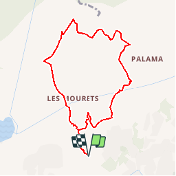
Trail Running of 9.1 km to be discovered at Provence-Alpes-Côte d'Azur, Bouches-du-Rhône, Marseille. This trail is proposed by tracegps.

Description

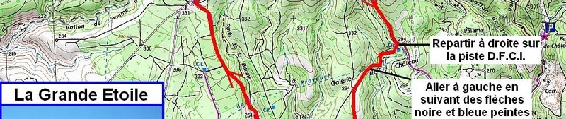
Hors les fortes chaleurs et les interdictions de circuler estivales, le danger dû à la prise de territoire des chasseurs en automne et le froid et le vent en hiver, c'est sans conteste au printemps qu'il faudra venir dans le masssif de l'Etoile !

Elevation profile

Photos

Positioning

Country:
France
Region :
Provence-Alpes-Côte d'Azur
Department/Province :
Bouches-du-Rhône
Municipality :
Marseille
Location:
13th Arrondissement
Start:(Dec)
Start:(UTM)
696313 ; 4803412 (31T) N.

Trails nearby

Trail Walking Marseille - Etoile - Photo
Walking
Spinnaker

Walking

Very easy
(1)
Marseille, Provence-Alpes-Côte d'Azur, Bouches-du-Rhône, France
10.7 km | 16.2 km-effort
2h 10min
Yes
Trail Mountain bike Marseille - 2013 05 04 l étoile - Photo
Mountain bike
lboubis

Mountain bike

Medium
(2)
Marseille, Provence-Alpes-Côte d'Azur, Bouches-du-Rhône, France
25 km | 36 km-effort
2h 19min
Yes
Trail Walking Marseille - La Grande Etoile - Photo
Walking
GUIDE
lhomme.ph

Walking

Medium
Marseille, Provence-Alpes-Côte d'Azur, Bouches-du-Rhône, France
15.4 km | 23 km-effort
4h 48min
Yes
Trail Walking Plan-de-Cuques - Vallon de la Mauvelle et des Ouides - Photo
Walking
cousam

Walking

Difficult
Plan-de-Cuques, Provence-Alpes-Côte d'Azur, Bouches-du-Rhône, France
9.6 km | 12.7 km-effort
3h 2min
Yes
Trail Walking Allauch - N D des Anges massif de l'étoile - Photo
Walking
cousam

Walking

Medium
Allauch, Provence-Alpes-Côte d'Azur, Bouches-du-Rhône, France
13.1 km | 19.5 km-effort
6h 51min
Yes
Trail Walking Allauch - le Pilon - Photo
Walking
cousam

Walking

Difficult
Allauch, Provence-Alpes-Côte d'Azur, Bouches-du-Rhône, France
15.3 km | 23 km-effort
7h 46min
Yes
Trail Walking Marseille - Boucle chaine de l’etoile - Photo
Walking
Briarwood

Walking

Difficult
Marseille, Provence-Alpes-Côte d'Azur, Bouches-du-Rhône, France
12 km | 18 km-effort
4h 44min
Yes
Trail Walking Allauch - Étoile- Tête de Jacquot  - Photo
Walking
junie

Walking

Easy
Allauch, Provence-Alpes-Côte d'Azur, Bouches-du-Rhône, France
12.3 km | 16.4 km-effort
3h 19min
Yes
Trail Walking Allauch - Pilon du Roi - Photo
Walking
aja

Walking

Medium
Allauch, Provence-Alpes-Côte d'Azur, Bouches-du-Rhône, France
14.2 km | 21 km-effort
4h 24min
Yes


Close
My subscriptions