Trail Cycle La Bégude-de-Mazenc - Vers Vesc - La Bégude de Mazenc - Photo

Vers Vesc - La Bégude de Mazenc

 tracegps
tracegps

User

© OpenStreetMap contributors
Length
Length
57 km
Max alt
Max alt
750 m
Uphill gradient
Uphill gradient
1056 m
Km-Effort
Km-Effort  
71 km
Min alt
Min alt
218 m
Downhill gradient
Downhill gradient
1060 m
Boucle
Boucle
No
Creation date :
2014-12-10 00:00:00.0
Updated on :
2014-12-10 00:00:00.0

(0 Reviews)

Cycle
Cycle
2h49
Difficulty : Difficult

Scan this QR Code to open this trail in the SityTrail application

FREE GPS app for hiking

Logo SityTrail SityTrail

IGN / Geographical institutes

Download SityTrail from the App Store Download SityTrail from Google Play

Logo SityTrail SityTrail World

The world is yours!

Download SityTrail from the App Store Download SityTrail from Google Play Download SityTrail on Huawei AppGallery

About

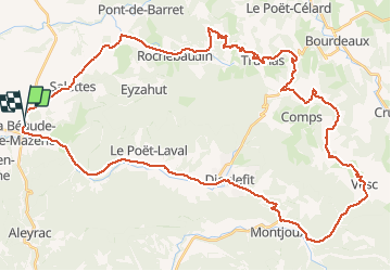
Trail Cycle of 57 km to be discovered at Auvergne-Rhône-Alpes, Drôme, La Bégude-de-Mazenc. This trail is proposed by tracegps.

Description

Belles côtes, belles descentes, bien vérifier les freins avant de partir !

Elevation profile

Photos

Positioning

Country:
France
Region :
Auvergne-Rhône-Alpes
Department/Province :
Drôme
Municipality :
La Bégude-de-Mazenc
Location:
Unknown
Start:(Dec)
Start:(UTM)
653815 ; 4934816 (31T) N.

Trails nearby

Trail Walking Charols - 2022-10-01_18h01m37_13052196 - Photo
Walking
chancha

Walking

Medium
(2)
Charols, Auvergne-Rhône-Alpes, Drôme, France
10.7 km | 13.6 km-effort
3h 2min
Yes
Trail Walking Portes-en-Valdaine - GPX-Rando-Plaine-Portoise-nouvelleversion - Photo
Walking
GUIDE
thonyc

Walking

Easy
(1)
Portes-en-Valdaine, Auvergne-Rhône-Alpes, Drôme, France
7.1 km | 8.2 km-effort
2h 0min
Yes
Trail Walking Portes-en-Valdaine - Portes-en-Valdaine Serre-de-Mirabel 11km. - Photo
Walking
chancha

Walking

Difficult
(1)
Portes-en-Valdaine, Auvergne-Rhône-Alpes, Drôme, France
10.8 km | 14.7 km-effort
3h 20min
Yes
Trail Walking La Touche - La Touche Crêtes de l'ysard 12km. - Photo
Walking
chancha

Walking

Difficult
(1)
La Touche, Auvergne-Rhône-Alpes, Drôme, France
12.1 km | 16.8 km-effort
3h 48min
Yes
Trail Walking Portes-en-Valdaine - 26 portes en valdaine - Photo
Walking
GUIDE
randodyssée

Walking

Very easy
Portes-en-Valdaine, Auvergne-Rhône-Alpes, Drôme, France
10.6 km | 14.5 km-effort
4h 10min
Yes
Trail Walking La Bégude-de-Mazenc - La Bégude de Mazenc - Serre de Forillon - Photo
Walking
tracegps

Walking

Medium
(1)
La Bégude-de-Mazenc, Auvergne-Rhône-Alpes, Drôme, France
8.1 km | 12 km-effort
2h 30min
Yes
Trail Cycle La Bégude-de-Mazenc - La Roche St Secret - Photo
Cycle
tracegps

Cycle

Medium
(1)
La Bégude-de-Mazenc, Auvergne-Rhône-Alpes, Drôme, France
46 km | 56 km-effort
2h 10min
Yes
Trail Walking La Bégude-de-Mazenc - 2022-12-16_08h55m45_tmpWriteApidae_269688_fr-1 - Photo
Walking
chancha

Walking

Difficult
La Bégude-de-Mazenc, Auvergne-Rhône-Alpes, Drôme, France
8.3 km | 12.3 km-effort
2h 44min
Yes
Trail On foot Portes-en-Valdaine - Rando des 15 en courant #26 - Photo
On foot
Julie LABBE

On foot

Medium
(1)
Portes-en-Valdaine, Auvergne-Rhône-Alpes, Drôme, France
19.4 km | 27 km-effort
6h 9min
Yes


Close
My subscriptions