![](/images/other/stat-length.png)
![Trail Snowshoes Belfahy - Le Tour de Belfahy - Photo](https://media.geolcdn.com/t/1900/400/ext.pjpeg?maxdim=2&url=https%3A%2F%2Fstatic1.geolcdn.com%2Fsiteimages%2Fupload%2Ffiles%2F1524743153raquette.jpg)
Le Tour de Belfahy
tracegps
User
![Length](/images/other/stat-length.png)
Length
6.4 km
![Max alt](https://static1.geolcdn.com/siteimages/upload/files/1508320355ic_sort_altitude_max_24dp.png)
Max alt
942 m
![Uphill gradient](https://static1.geolcdn.com/siteimages/upload/files/1508320355ic_sort_den_pos_24dp.png)
Uphill gradient
265 m
![Km-Effort](/images/other/stat-length.png)
Km-Effort
9.9 km
![Min alt](https://static1.geolcdn.com/siteimages/upload/files/1508320355ic_sort_altitude_min_24dp.png)
Min alt
783 m
![Downhill gradient](https://static1.geolcdn.com/siteimages/upload/files/1508320355ic_sort_den_neg_24dp.png)
Downhill gradient
260 m
![Boucle](https://static1.geolcdn.com/siteimages/upload/files/16400158638029165_repeat_loop_refresh_sync_direction_icon.png)
Boucle
Yes
Creation date :
2014-12-10 00:00:00.0
Updated on :
2014-12-10 00:00:00.0
![Snowshoes](https://static1.geolcdn.com/sitytour/trail-icons/504.png)
2h30
Difficulty : Medium
![Scan this QR Code to open this trail in the SityTrail application](https://capi.geolives.com/qq0zvz2zws4bq2lad0pu/sitytour/trails/104297/qr.png?size=200)
FREE GPS app for hiking
About
Trail Snowshoes of 6.4 km to be discovered at Bourgogne-Franche-Comté, Haute-Saône, Belfahy. This trail is proposed by tracegps.
Description
Circuit trés sympathique que nous avons effectué sous la neige en décembre. Le refuge du CBL se trouve sur le parcours, il existe egalement une auberge à Belfahy… Se garer au parking central de Belfahy
Positioning
Country:
France
Region :
Bourgogne-Franche-Comté
Department/Province :
Haute-Saône
Municipality :
Belfahy
Location:
Unknown
Start:(Dec)
Start:(UTM)
329975 ; 5294778 (32T) N.
Comments
Trails nearby
![Trail Walking Auxelles-Haut - planche belles filles par auxelle haut - Photo](https://media.geolcdn.com/t/375/260/ext.jpg?maxdim=2&url=https%3A%2F%2Fservices.sitytrail.com%2FGeolivesWS%2FDownloadMedia.ashx%3FTrailID%3D305224%26Media%3D10d34718-818e-4b54-8a0e-bb1d508617db.JPG)
![Walking Walking](https://static1.geolcdn.com/sitytour/trail-icons/101.png)
planche belles filles par auxelle haut
Walking
Medium
(3)
Auxelles-Haut,
Bourgogne-Franche-Comté,
Territoire-de-Belfort,
France
![](/images/other/stat-length.png)
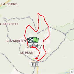
14.6 km | 23 km-effort
4h 55min
![](https://static1.geolcdn.com/siteimages/upload/files/16400158638029165_repeat_loop_refresh_sync_direction_icon.png)
Yes
![Trail Walking Plancher-les-Mines - Le Ballon de Servance - Photo](https://media.geolcdn.com/t/375/260/ext.jpg?maxdim=2&url=https%3A%2F%2Fservices.sitytrail.com%2FGeolivesWS%2FDownloadMedia.ashx%3FTrailID%3D109643%26Media%3D4284_1.jpg)
![Walking Walking](https://static1.geolcdn.com/sitytour/trail-icons/101.png)
Le Ballon de Servance
Walking
Difficult
(2)
Plancher-les-Mines,
Bourgogne-Franche-Comté,
Haute-Saône,
France
![](/images/other/stat-length.png)
19.7 km | 30 km-effort
6h 0min
![](https://static1.geolcdn.com/siteimages/upload/files/16400158638029165_repeat_loop_refresh_sync_direction_icon.png)
Yes
![Trail Walking Plancher-les-Mines - 2019-08-07 Balade Plancher des belles filles - Photo](https://media.geolcdn.com/t/375/260/66a371f6-1837-4f48-9b52-0abd1c8fe413.jpg&format=jpg&maxdim=2)
![Walking Walking](https://static1.geolcdn.com/sitytour/trail-icons/101.png)
2019-08-07 Balade Plancher des belles filles
Walking
Very easy
Plancher-les-Mines,
Bourgogne-Franche-Comté,
Haute-Saône,
France
![](/images/other/stat-length.png)
7.8 km | 11.9 km-effort
2h 12min
![](https://static1.geolcdn.com/siteimages/upload/files/16400158638029165_repeat_loop_refresh_sync_direction_icon.png)
Yes
![Trail Walking Servance-Miellin - 2019-08-06 Marche Ballon Servance Ballon Alsace - Photo](https://media.geolcdn.com/t/375/260/452d83b8-7651-47fa-bbef-bff585b94030.jpg&format=jpg&maxdim=2)
![Walking Walking](https://static1.geolcdn.com/sitytour/trail-icons/101.png)
2019-08-06 Marche Ballon Servance Ballon Alsace
Walking
Very difficult
Servance-Miellin,
Bourgogne-Franche-Comté,
Haute-Saône,
France
![](/images/other/stat-length.png)
19.9 km | 31 km-effort
6h 23min
![](https://static1.geolcdn.com/siteimages/upload/files/16400158638029165_repeat_loop_refresh_sync_direction_icon.png)
Yes
![Trail Walking Plancher-les-Mines - Plancher les mines - sentier des mines - croix du choléra - Planche des Belles Filles - sentier FFI - Mont Menard - Plancher les Mines - Photo](https://media.geolcdn.com/t/375/260/f7fa7cdf-da22-406f-8d96-8f9f07e4fd3d.jpg&format=jpg&maxdim=2)
![Walking Walking](https://static1.geolcdn.com/sitytour/trail-icons/101.png)
Plancher les mines - sentier des mines - croix du choléra - Planche des Belle...
Walking
Very difficult
Plancher-les-Mines,
Bourgogne-Franche-Comté,
Haute-Saône,
France
![](/images/other/stat-length.png)
14.3 km | 25 km-effort
5h 38min
![](https://static1.geolcdn.com/siteimages/upload/files/16400158638029165_repeat_loop_refresh_sync_direction_icon.png)
Yes
![Trail Walking Plancher-les-Mines - Cascades de la Goutte des Saules - Belvédère - Grotte St Antoine - Photo](https://media.geolcdn.com/t/375/260/675d2d72-2ae5-41bd-abbb-b7f938827506.jpg&format=jpg&maxdim=2)
![Walking Walking](https://static1.geolcdn.com/sitytour/trail-icons/101.png)
Cascades de la Goutte des Saules - Belvédère - Grotte St Antoine
Walking
Medium
Plancher-les-Mines,
Bourgogne-Franche-Comté,
Haute-Saône,
France
![](/images/other/stat-length.png)
6.6 km | 11.2 km-effort
2h 32min
![](https://static1.geolcdn.com/siteimages/upload/files/16400158638029165_repeat_loop_refresh_sync_direction_icon.png)
Yes
![Trail Walking Plancher-les-Mines - 130722 - La planche des belles - au pieds du Ballons d’Alsaces - Photo](https://media.geolcdn.com/t/375/260/63970d70-3d7a-4dbb-88a1-8a2718140e81.jpg&format=jpg&maxdim=2)
![Walking Walking](https://static1.geolcdn.com/sitytour/trail-icons/101.png)
130722 - La planche des belles - au pieds du Ballons d’Alsaces
Walking
Medium
Plancher-les-Mines,
Bourgogne-Franche-Comté,
Haute-Saône,
France
![](/images/other/stat-length.png)
16.5 km | 24 km-effort
3h 45min
![](https://static1.geolcdn.com/siteimages/upload/files/16400158638029165_repeat_loop_refresh_sync_direction_icon.png)
Yes
![Trail Walking Servance-Miellin - Belfahy depuis Miellin - Photo](https://media.geolcdn.com/t/375/260/affc61f4-0ec2-4c6a-a8b6-ea7a60025d69.jpg&format=jpg&maxdim=2)
![Walking Walking](https://static1.geolcdn.com/sitytour/trail-icons/101.png)
Belfahy depuis Miellin
Walking
Medium
Servance-Miellin,
Bourgogne-Franche-Comté,
Haute-Saône,
France
![](/images/other/stat-length.png)
13.5 km | 21 km-effort
3h 4min
![](https://static1.geolcdn.com/siteimages/upload/files/16400158638029165_repeat_loop_refresh_sync_direction_icon.png)
Yes
![Trail Walking Auxelles-Haut - auxelles hauts - Photo](https://media.geolcdn.com/t/375/260/11d9cee7-d94d-433f-a992-d3059a15b6fe.jpg&format=jpg&maxdim=2)
![Walking Walking](https://static1.geolcdn.com/sitytour/trail-icons/101.png)
auxelles hauts
Walking
Medium
Auxelles-Haut,
Bourgogne-Franche-Comté,
Territoire-de-Belfort,
France
![](/images/other/stat-length.png)
16 km | 27 km-effort
4h 20min
![](https://static1.geolcdn.com/siteimages/upload/files/16400158638029165_repeat_loop_refresh_sync_direction_icon.png)
Yes