![](/images/other/stat-length.png)
![Trail Cycle Saint-Mitre-les-Remparts - Saint Mitre Les Remparts - Lus la Croix Haute - Photo](https://media.geolcdn.com/t/1900/400/ext.pjpeg?maxdim=2&url=https%3A%2F%2Fservices.sitytrail.com%2FGeolivesWS%2FDownloadMedia.ashx%3FTrailID%3D104179%26Media%3D7303_1.jpg)
Saint Mitre Les Remparts - Lus la Croix Haute
tracegps
User
![Length](/images/other/stat-length.png)
Length
248 km
![Max alt](https://static1.geolcdn.com/siteimages/upload/files/1508320355ic_sort_altitude_max_24dp.png)
Max alt
1018 m
![Uphill gradient](https://static1.geolcdn.com/siteimages/upload/files/1508320355ic_sort_den_pos_24dp.png)
Uphill gradient
3644 m
![Km-Effort](/images/other/stat-length.png)
Km-Effort
293 km
![Min alt](https://static1.geolcdn.com/siteimages/upload/files/1508320355ic_sort_altitude_min_24dp.png)
Min alt
0 m
![Downhill gradient](https://static1.geolcdn.com/siteimages/upload/files/1508320355ic_sort_den_neg_24dp.png)
Downhill gradient
2694 m
![Boucle](https://static1.geolcdn.com/siteimages/upload/files/16400158638029165_repeat_loop_refresh_sync_direction_icon.png)
Boucle
No
Creation date :
2014-12-10 00:00:00.0
Updated on :
2014-12-10 00:00:00.0
![Cycle](https://static1.geolcdn.com/sitytour/trail-icons/200.png)
11h00
Difficulty : Difficult
![Scan this QR Code to open this trail in the SityTrail application](https://capi.geolives.com/qq0zvz2zws4bq2lad0pu/sitytour/trails/104179/qr.png?size=200)
FREE GPS app for hiking
About
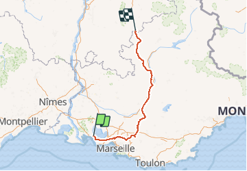
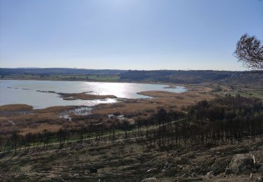
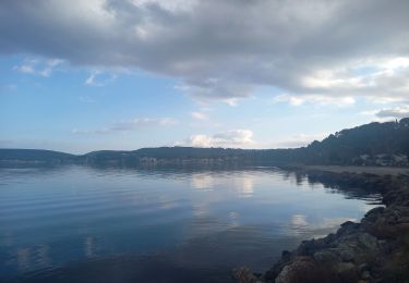
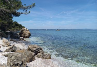
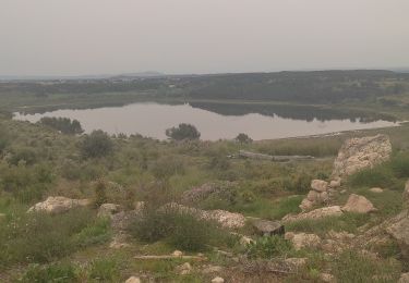
Trail Cycle of 248 km to be discovered at Provence-Alpes-Côte d'Azur, Bouches-du-Rhône, Saint-Mitre-les-Remparts. This trail is proposed by tracegps.
Description
Remontée en Trike électrique depuis St Mitre Jusqu'à Lus la Croix Haute. Pas assez de jus pour aller jusqu'à Grenoble...
Positioning
Country:
France
Region :
Provence-Alpes-Côte d'Azur
Department/Province :
Bouches-du-Rhône
Municipality :
Saint-Mitre-les-Remparts
Location:
Unknown
Start:(Dec)
Start:(UTM)
663925 ; 4812592 (31T) N.
Comments
Trails nearby
![Trail On foot Port-de-Bouc - La Presqu’ile - Le sentier du littoral - Photo](https://media.geolcdn.com/t/375/260/ext.jpg?maxdim=2&url=https%3A%2F%2Fmedia.geolcdn.com%2Ff%2F7fd51f05-a6e7-42de-ab91-8a11cdb4314b.jpeg)
![On foot On foot](https://static1.geolcdn.com/sitytour/trail-icons/100.png)
La Presqu’ile - Le sentier du littoral
On foot
Easy
Port-de-Bouc,
Provence-Alpes-Côte d'Azur,
Bouches-du-Rhône,
France
![](/images/other/stat-length.png)
3.9 km | 4.5 km-effort
1h 0min
![](https://static1.geolcdn.com/siteimages/upload/files/16400158638029165_repeat_loop_refresh_sync_direction_icon.png)
Yes
![Trail On foot Saint-Mitre-les-Remparts - Forêt de Castillon Etang de Saint-Blaise - Photo](https://media.geolcdn.com/t/375/260/ext.jpg?maxdim=2&url=https%3A%2F%2Fmedia.geolcdn.com%2Ff%2F7e8fefba-ad96-4968-8724-bd86e53a7bcd.jpeg)
![On foot On foot](https://static1.geolcdn.com/sitytour/trail-icons/100.png)
Forêt de Castillon Etang de Saint-Blaise
On foot
Easy
Saint-Mitre-les-Remparts,
Provence-Alpes-Côte d'Azur,
Bouches-du-Rhône,
France
![](/images/other/stat-length.png)
6.1 km | 7.1 km-effort
1h 36min
![](https://static1.geolcdn.com/siteimages/upload/files/16400158638029165_repeat_loop_refresh_sync_direction_icon.png)
No
![Trail On foot Saint-Mitre-les-Remparts - Entre mer et étangs - Photo](https://media.geolcdn.com/t/375/260/ext.jpg?maxdim=2&url=https%3A%2F%2Fmedia.geolcdn.com%2Ff%2F95277df0-03ce-438e-8003-6258ba4d95b2.jpeg)
![On foot On foot](https://static1.geolcdn.com/sitytour/trail-icons/100.png)
Entre mer et étangs
On foot
Very difficult
Saint-Mitre-les-Remparts,
Provence-Alpes-Côte d'Azur,
Bouches-du-Rhône,
France
![](/images/other/stat-length.png)
39 km | 46 km-effort
10h 22min
![](https://static1.geolcdn.com/siteimages/upload/files/16400158638029165_repeat_loop_refresh_sync_direction_icon.png)
Yes
![Trail On foot Saint-Mitre-les-Remparts - Du Crépon aux Rocalèdes - Photo](https://media.geolcdn.com/t/375/260/ext.jpg?maxdim=2&url=https%3A%2F%2Fmedia.geolcdn.com%2Ff%2F4fcd6c22-ec02-4372-a0e0-40334c408df3.jpeg)
![On foot On foot](https://static1.geolcdn.com/sitytour/trail-icons/100.png)
Du Crépon aux Rocalèdes
On foot
Easy
Saint-Mitre-les-Remparts,
Provence-Alpes-Côte d'Azur,
Bouches-du-Rhône,
France
![](/images/other/stat-length.png)
6.1 km | 8 km-effort
1h 49min
![](https://static1.geolcdn.com/siteimages/upload/files/16400158638029165_repeat_loop_refresh_sync_direction_icon.png)
Yes
![Trail On foot Port-de-Bouc - Forêt de Castillon Etangs de Pourra et d’Engrenier - Photo](https://media.geolcdn.com/t/375/260/ext.jpg?maxdim=2&url=https%3A%2F%2Fmedia.geolcdn.com%2Ff%2Fb4485374-af03-4dfc-85d7-4833d4297133.jpeg)
![On foot On foot](https://static1.geolcdn.com/sitytour/trail-icons/100.png)
Forêt de Castillon Etangs de Pourra et d’Engrenier
On foot
Easy
Port-de-Bouc,
Provence-Alpes-Côte d'Azur,
Bouches-du-Rhône,
France
![](/images/other/stat-length.png)
6.1 km | 7.7 km-effort
1h 45min
![](https://static1.geolcdn.com/siteimages/upload/files/16400158638029165_repeat_loop_refresh_sync_direction_icon.png)
No
![Trail On foot Saint-Mitre-les-Remparts - Les Tours Gros - Photo](https://media.geolcdn.com/t/375/260/ext.jpg?maxdim=2&url=https%3A%2F%2Fmedia.geolcdn.com%2Ff%2F4fcd6c22-ec02-4372-a0e0-40334c408df3.jpeg)
![On foot On foot](https://static1.geolcdn.com/sitytour/trail-icons/100.png)
Les Tours Gros
On foot
Easy
Saint-Mitre-les-Remparts,
Provence-Alpes-Côte d'Azur,
Bouches-du-Rhône,
France
![](/images/other/stat-length.png)
6.2 km | 7.9 km-effort
1h 48min
![](https://static1.geolcdn.com/siteimages/upload/files/16400158638029165_repeat_loop_refresh_sync_direction_icon.png)
Yes
![Trail Walking Saint-Mitre-les-Remparts - Étangs de St Mitre les remparts - Photo](https://media.geolcdn.com/t/375/260/ext.jpg?maxdim=2&url=https%3A%2F%2Fmedia.geolcdn.com%2Ff%2F9fc53335-d16b-4530-830f-8b639b754ae2.jpg)
![Walking Walking](https://static1.geolcdn.com/sitytour/trail-icons/101.png)
Étangs de St Mitre les remparts
Walking
Easy
Saint-Mitre-les-Remparts,
Provence-Alpes-Côte d'Azur,
Bouches-du-Rhône,
France
![](/images/other/stat-length.png)
8 km | 9.6 km-effort
3h 36min
![](https://static1.geolcdn.com/siteimages/upload/files/16400158638029165_repeat_loop_refresh_sync_direction_icon.png)
No
![Trail Walking Istres - Martigues entre les étangs de Citis et Lavalduc - Photo](https://media.geolcdn.com/t/375/260/ext.jpg?maxdim=2&url=https%3A%2F%2Fmedia.geolcdn.com%2Ff%2F3676fb10-77ad-438e-9273-065789ad9a3e.jpg)
![Walking Walking](https://static1.geolcdn.com/sitytour/trail-icons/101.png)
Martigues entre les étangs de Citis et Lavalduc
Walking
Medium
Istres,
Provence-Alpes-Côte d'Azur,
Bouches-du-Rhône,
France
![](/images/other/stat-length.png)
6.9 km | 8.3 km-effort
1h 53min
![](https://static1.geolcdn.com/siteimages/upload/files/16400158638029165_repeat_loop_refresh_sync_direction_icon.png)
Yes
![Trail Walking Martigues - Figuerrolles - Photo](https://media.geolcdn.com/t/375/260/ext.jpg?maxdim=2&url=https%3A%2F%2Fmedia.geolcdn.com%2Ff%2F4a5f1588-9bfa-4aa2-87f0-3f537570d4aa.jpg)
![Walking Walking](https://static1.geolcdn.com/sitytour/trail-icons/101.png)
Figuerrolles
Walking
Easy
Martigues,
Provence-Alpes-Côte d'Azur,
Bouches-du-Rhône,
France
![](/images/other/stat-length.png)
6.1 km | 7.4 km-effort
1h 43min
![](https://static1.geolcdn.com/siteimages/upload/files/16400158638029165_repeat_loop_refresh_sync_direction_icon.png)
Yes