Trail Mountain bike La Charmée - Navois - La Charmée - Photo
 tracegps
tracegps

User

© OpenStreetMap contributors
Length
Length
49 km
Max alt
Max alt
477 m
Uphill gradient
Uphill gradient
819 m
Km-Effort
Km-Effort  
60 km
Min alt
Min alt
175 m
Downhill gradient
Downhill gradient
820 m
Boucle
Boucle
Yes
Creation date :
2014-12-10 00:00:00.0
Updated on :
2014-12-10 00:00:00.0

(0 Reviews)

Mountain bike
Mountain bike
3h30
Difficulty : Difficult

Scan this QR Code to open this trail in the SityTrail application

FREE GPS app for hiking

Logo SityTrail SityTrail

IGN / Geographical institutes

Download SityTrail from the App Store Download SityTrail from Google Play

Logo SityTrail SityTrail World

The world is yours!

Download SityTrail from the App Store Download SityTrail from Google Play Download SityTrail on Huawei AppGallery

About

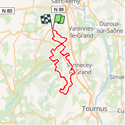
Trail Mountain bike of 49 km to be discovered at Bourgogne-Franche-Comté, Saône-et-Loire, La Charmée. This trail is proposed by tracegps.

Description

Départ de La Charmée à l'orée des bois, passage en forêt pendant quelques km puis après un peu de "goudron" côtoyer la Grosne quelques instants pour se diriger vers Nanton... et montée vers Le Navois, redescente vers Laives en passant par Monceau Ragny et près de l'Eglise Saint Martin de Laives. Retour par les lacs de Laives (attention parcours VITA). En période estivale vous devrez éviter les lacs qui sont barrés. Dévier à gauche avant ceux-ci et reprendre la route jusqu'à La Ferté.

Elevation profile

Positioning

Country:
France
Region :
Bourgogne-Franche-Comté
Department/Province :
Saône-et-Loire
Municipality :
La Charmée
Location:
Unknown
Start:(UTM)
637063 ; 5175046 (31T) N.

Trails nearby

Trail Nordic walking Sevrey - sevrey - Photo
Nordic walking
patourad

Nordic walking

Very easy
(1)
Sevrey, Bourgogne-Franche-Comté, Saône-et-Loire, France
9.7 km | 10.2 km-effort
1h 37min
Yes
Trail Cycle Lux - LUX LA SAÔNE - Photo
Cycle
doclocjl

Cycle

Very easy
Lux, Bourgogne-Franche-Comté, Saône-et-Loire, France
7.7 km | 8.4 km-effort
1h 52min
Yes
Trail Walking Lux - Lux : la Saône  - Photo
Walking
Brougeons

Walking

Very easy
Lux, Bourgogne-Franche-Comté, Saône-et-Loire, France
9.2 km | 10 km-effort
2h 14min
Yes
Trail Walking La Charmée - la charmée - Photo
Walking
tountouri

Walking

Medium
La Charmée, Bourgogne-Franche-Comté, Saône-et-Loire, France
5.7 km | 6.2 km-effort
1h 17min
No
Trail Walking La Charmée - G . La Charmée Nord - Battrey - bois du temple - Le Piony - Mépilley et retour par champ Guenard . - Photo
Walking
jeanpaulcheyssac

Walking

Medium
La Charmée, Bourgogne-Franche-Comté, Saône-et-Loire, France
10.2 km | 11.3 km-effort
2h 33min
Yes
Trail Walking La Charmée - P . L a Charmée - Battrey - Les deux chenes - La Loge retourpar les Meix . - Photo
Walking
jeanpaulcheyssac

Walking

Medium
La Charmée, Bourgogne-Franche-Comté, Saône-et-Loire, France
10.1 km | 11.1 km-effort
2h 31min
Yes
Trail Walking Lux - P . Lux - bords de Saone - Etang Morin - retour par terres de Fontaine  - Photo
Walking
jeanpaulcheyssac

Walking

Medium
Lux, Bourgogne-Franche-Comté, Saône-et-Loire, France
8.3 km | 9.3 km-effort
2h 6min
Yes
Trail Walking Givry - P . Fontaine couverte Nord . - Photo
Walking
jeanpaulcheyssac

Walking

Medium
Givry, Bourgogne-Franche-Comté, Saône-et-Loire, France
9.1 km | 10.1 km-effort
2h 17min
Yes
Trail Walking Givry - P. Fontaines couverte Sud  - Photo
Walking
jeanpaulcheyssac

Walking

Medium
Givry, Bourgogne-Franche-Comté, Saône-et-Loire, France
7.2 km | 8.1 km-effort
1h 50min
Yes


Close
My subscriptions