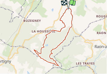
![](/images/other/stat-length.png)
![Trail Mountain bike Hadol - Espace VTT FFC Chemins du Coeur des Vosges - circuit n°24 - Les Rossieux - Photo](https://media.geolcdn.com/t/1900/400/ext.pjpeg?maxdim=2&url=https%3A%2F%2Fservices.sitytrail.com%2FGeolivesWS%2FDownloadMedia.ashx%3FTrailID%3D104123%26Media%3D7193_1.jpg)
Espace VTT FFC Chemins du Coeur des Vosges - circuit n°24 - Les Rossieux
tracegps
User
![Length](/images/other/stat-length.png)
![Max alt](https://static1.geolcdn.com/siteimages/upload/files/1508320355ic_sort_altitude_max_24dp.png)
![Uphill gradient](https://static1.geolcdn.com/siteimages/upload/files/1508320355ic_sort_den_pos_24dp.png)
![Km-Effort](/images/other/stat-length.png)
![Min alt](https://static1.geolcdn.com/siteimages/upload/files/1508320355ic_sort_altitude_min_24dp.png)
![Downhill gradient](https://static1.geolcdn.com/siteimages/upload/files/1508320355ic_sort_den_neg_24dp.png)
![Boucle](https://static1.geolcdn.com/siteimages/upload/files/16400158638029165_repeat_loop_refresh_sync_direction_icon.png)
![Mountain bike](https://static1.geolcdn.com/sitytour/trail-icons/202.png)
1h19
Difficulty : Medium
![Scan this QR Code to open this trail in the SityTrail application](https://capi.geolives.com/qq0zvz2zws4bq2lad0pu/sitytour/trails/104123/qr.png?size=200)
FREE GPS app for hiking
About
Trail Mountain bike of 16.1 km to be discovered at Grand Est, Vosges, Hadol. This trail is proposed by tracegps.
Description
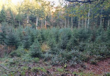
Espace VTT FFC Chemins du Cœur des Vosges - circuit n°24 - Les Rossieux Circuit officiel labellisé par la Fédération Française de Cyclisme. A l’orée du Pays de la Vôge, au sein du massif collinaire des Monts Faucilles, vous cheminez entre sous-bois et forêts et découvrez les versants boisés mais peu abrupts du bois des Rossieux.
Positioning
Comments
Trails nearby
![Trail On foot Raon-aux-Bois - Sentier](https://media.geolcdn.com/t/375/260/906ec9db-57ed-4e19-8504-e7673b4aefeb.jpeg&format=jpg&maxdim=2)
![On foot On foot](https://static1.geolcdn.com/sitytour/trail-icons/100.png)
On foot
![](/images/other/stat-length.png)
![](https://static1.geolcdn.com/siteimages/upload/files/16400158638029165_repeat_loop_refresh_sync_direction_icon.png)
![Trail On foot Raon-aux-Bois - Raon-aux-Bois - Circuit 3 - Photo](https://media.geolcdn.com/t/375/260/1915659e-2ae3-42c7-b754-84e2dc5c8a5e.jpeg&format=jpg&maxdim=2)
![On foot On foot](https://static1.geolcdn.com/sitytour/trail-icons/100.png)
On foot
![](/images/other/stat-length.png)
![](https://static1.geolcdn.com/siteimages/upload/files/16400158638029165_repeat_loop_refresh_sync_direction_icon.png)
![Trail On foot Raon-aux-Bois - Raon-aux-Bois - Circuit 2 - Photo](https://media.geolcdn.com/t/375/260/1915659e-2ae3-42c7-b754-84e2dc5c8a5e.jpeg&format=jpg&maxdim=2)
![On foot On foot](https://static1.geolcdn.com/sitytour/trail-icons/100.png)
On foot
![](/images/other/stat-length.png)
![](https://static1.geolcdn.com/siteimages/upload/files/16400158638029165_repeat_loop_refresh_sync_direction_icon.png)
![Trail On foot Raon-aux-Bois - Raon-aux-Bois - Circuit 1 - Photo](https://media.geolcdn.com/t/375/260/1915659e-2ae3-42c7-b754-84e2dc5c8a5e.jpeg&format=jpg&maxdim=2)
![On foot On foot](https://static1.geolcdn.com/sitytour/trail-icons/100.png)
On foot
![](/images/other/stat-length.png)
![](https://static1.geolcdn.com/siteimages/upload/files/16400158638029165_repeat_loop_refresh_sync_direction_icon.png)
![Trail On foot Raon-aux-Bois - Sentier](https://media.geolcdn.com/t/375/260/906ec9db-57ed-4e19-8504-e7673b4aefeb.jpeg&format=jpg&maxdim=2)
![On foot On foot](https://static1.geolcdn.com/sitytour/trail-icons/100.png)
On foot
![](/images/other/stat-length.png)
![](https://static1.geolcdn.com/siteimages/upload/files/16400158638029165_repeat_loop_refresh_sync_direction_icon.png)
![Trail Walking Raon-aux-Bois - teleton - Photo](https://media.geolcdn.com/t/375/260/ext.jpg?maxdim=2&url=https%3A%2F%2Fstatic1.geolcdn.com%2Fsiteimages%2Fupload%2Ffiles%2F1553511878bg_sport_marche.png)
![Walking Walking](https://static1.geolcdn.com/sitytour/trail-icons/101.png)
Walking
![](/images/other/stat-length.png)
![](https://static1.geolcdn.com/siteimages/upload/files/16400158638029165_repeat_loop_refresh_sync_direction_icon.png)
![Trail Walking Hadol - hadol - Photo](https://media.geolcdn.com/t/375/260/ext.jpg?maxdim=2&url=https%3A%2F%2Fservices.sitytrail.com%2FGeolivesWS%2FDownloadMedia.ashx%3FTrailID%3D45357%26Media%3Dimage6.jpg)
![Walking Walking](https://static1.geolcdn.com/sitytour/trail-icons/101.png)
![Trail Walking Hadol - 2010-09-05 - 12h00m55 - Photo](https://media.geolcdn.com/t/375/260/ext.jpg?maxdim=2&url=https%3A%2F%2Fservices.sitytrail.com%2FGeolivesWS%2FDownloadMedia.ashx%3FTrailID%3D45319%26Media%3D20100905112812.jpg)
![Walking Walking](https://static1.geolcdn.com/sitytour/trail-icons/101.png)
Walking
![](/images/other/stat-length.png)
![](https://static1.geolcdn.com/siteimages/upload/files/16400158638029165_repeat_loop_refresh_sync_direction_icon.png)
![Trail Walking Raon-aux-Bois - Circuit Raon aux bois depuis parcours sportif - Photo](https://media.geolcdn.com/t/375/260/28555a57-7448-48fd-8ef7-a4f39e721b44.jpg&format=jpg&maxdim=2)
![Walking Walking](https://static1.geolcdn.com/sitytour/trail-icons/101.png)
Walking
![](/images/other/stat-length.png)
![](https://static1.geolcdn.com/siteimages/upload/files/16400158638029165_repeat_loop_refresh_sync_direction_icon.png)