![](/images/other/stat-length.png)
![Trail Mountain bike Hauteroche - Centre VTT FFC Premier Plateau, entre Lacs et Vignobles - Au bord de la Reculée - Circuit n°13 - Photo](https://media.geolcdn.com/t/1900/400/ext.pjpeg?maxdim=2&url=https%3A%2F%2Fservices.sitytrail.com%2FGeolivesWS%2FDownloadMedia.ashx%3FTrailID%3D104101%26Media%3D7146_3.jpg)
Centre VTT FFC Premier Plateau, entre Lacs et Vignobles - Au bord de la Reculée - Circuit n°13
tracegps
User
![Length](/images/other/stat-length.png)
![Max alt](https://static1.geolcdn.com/siteimages/upload/files/1508320355ic_sort_altitude_max_24dp.png)
![Uphill gradient](https://static1.geolcdn.com/siteimages/upload/files/1508320355ic_sort_den_pos_24dp.png)
![Km-Effort](/images/other/stat-length.png)
![Min alt](https://static1.geolcdn.com/siteimages/upload/files/1508320355ic_sort_altitude_min_24dp.png)
![Downhill gradient](https://static1.geolcdn.com/siteimages/upload/files/1508320355ic_sort_den_neg_24dp.png)
![Boucle](https://static1.geolcdn.com/siteimages/upload/files/16400158638029165_repeat_loop_refresh_sync_direction_icon.png)
![Mountain bike](https://static1.geolcdn.com/sitytour/trail-icons/202.png)
1h00
Difficulty : Difficult
![Scan this QR Code to open this trail in the SityTrail application](https://capi.geolives.com/qq0zvz2zws4bq2lad0pu/sitytour/trails/104101/qr.png?size=200)
FREE GPS app for hiking
About
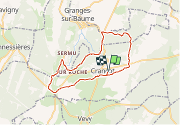
Trail Mountain bike of 14.5 km to be discovered at Bourgogne-Franche-Comté, Jura, Hauteroche. This trail is proposed by tracegps.
Description
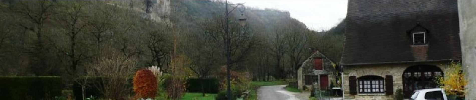
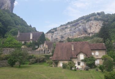
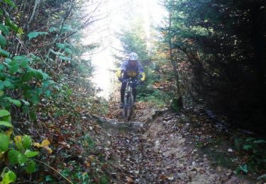
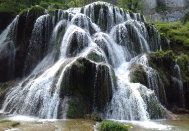
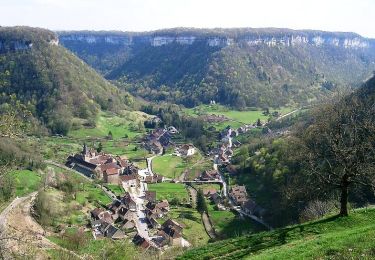
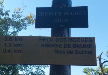
Centre VTT - FFC Premier Plateau, entre Lacs et Vignobles. Circuit labellisé par la Fédération Française de Cyclisme. Centre VTT FFC Premier Plateau, entre Lacs et Vignobles – Au bord de la Reculée - Circuit n°13 Départ de Crançot En empruntant ce circuit vous serez invités à observer depuis les belvédères surplombants la Reculée de Baume les Messieurs, la pierre du Premier Plateau à l'état naturel, mais aussi son utilisation par l'homme grâce au passage dans le village de Crançot et à des murgers et cabanes de bergers répartis tous au long du parcours. Circuit rouge en raison du superbe single le long des falaises de la Reculée de Baume. Le reste est très roulant. Faible dénivelé accessible à tous. Ce tracé a été relevé sur le terrain par le club Vtt Conliège.
Positioning
Comments
Trails nearby
![Trail Walking Baume-les-Messieurs - Baume-les-Messieurs - Photo](https://media.geolcdn.com/t/375/260/ext.jpg?maxdim=2&url=https%3A%2F%2Fservices.sitytrail.com%2FGeolivesWS%2FDownloadMedia.ashx%3FTrailID%3D792634%26Media%3Dfix__20170719130529.jpg)
![Walking Walking](https://static1.geolcdn.com/sitytour/trail-icons/101.png)
Walking
![](/images/other/stat-length.png)
![](https://static1.geolcdn.com/siteimages/upload/files/16400158638029165_repeat_loop_refresh_sync_direction_icon.png)
![Trail Mountain bike Briod - Centre VTT FFC Premier Plateau, entre Lacs et Vignobles - La Haute Roche - Circuit n°11 - Photo](https://media.geolcdn.com/t/375/260/ext.jpg?maxdim=2&url=https%3A%2F%2Fservices.sitytrail.com%2FGeolivesWS%2FDownloadMedia.ashx%3FTrailID%3D104100%26Media%3D7145_4.jpg)
![Mountain bike Mountain bike](https://static1.geolcdn.com/sitytour/trail-icons/202.png)
Mountain bike
![](/images/other/stat-length.png)
![](https://static1.geolcdn.com/siteimages/upload/files/16400158638029165_repeat_loop_refresh_sync_direction_icon.png)
![Trail Walking Baume-les-Messieurs - Baume Les Messieurs Falaises et Reculées page 148 - Photo](https://media.geolcdn.com/t/375/260/acd5524e-71ab-4cdd-8d98-f51002ff3690.jpg&format=jpg&maxdim=2)
![Walking Walking](https://static1.geolcdn.com/sitytour/trail-icons/101.png)
Walking
![](/images/other/stat-length.png)
![](https://static1.geolcdn.com/siteimages/upload/files/16400158638029165_repeat_loop_refresh_sync_direction_icon.png)
![Trail Walking Baume-les-Messieurs - La reculée de Baume les Messieurs - Photo](https://media.geolcdn.com/t/375/260/ext.jpg?maxdim=2&url=https%3A%2F%2Fservices.sitytrail.com%2FGeolivesWS%2FDownloadMedia.ashx%3FTrailID%3D109679%26Media%3D4341_1.jpg)
![Walking Walking](https://static1.geolcdn.com/sitytour/trail-icons/101.png)
Walking
![](/images/other/stat-length.png)
![](https://static1.geolcdn.com/siteimages/upload/files/16400158638029165_repeat_loop_refresh_sync_direction_icon.png)
![Trail Walking Baume-les-Messieurs - Reculée de Baume-les-Messieurs - Photo](https://media.geolcdn.com/t/375/260/ext.jpg?maxdim=2&url=https%3A%2F%2Fstatic1.geolcdn.com%2Fsiteimages%2Fupload%2Ffiles%2F1553511878bg_sport_marche.png)
![Walking Walking](https://static1.geolcdn.com/sitytour/trail-icons/101.png)
Walking
![](/images/other/stat-length.png)
![](https://static1.geolcdn.com/siteimages/upload/files/16400158638029165_repeat_loop_refresh_sync_direction_icon.png)
![Trail Walking Baume-les-Messieurs - Baume les messieurs les échelles de Sermu page 166 - Photo](https://media.geolcdn.com/t/375/260/98bc4c1d-13b5-43da-8ac3-6d94a6c79eb7.jpg&format=jpg&maxdim=2)
![Walking Walking](https://static1.geolcdn.com/sitytour/trail-icons/101.png)
Walking
![](/images/other/stat-length.png)
![](https://static1.geolcdn.com/siteimages/upload/files/16400158638029165_repeat_loop_refresh_sync_direction_icon.png)
![Trail Walking Baume-les-Messieurs - Le tour du Cirque de Baume-les-Messieurs - Photo](https://media.geolcdn.com/t/375/260/65149169-0d37-4056-8013-6b139c605190.jpg&format=jpg&maxdim=2)
![Walking Walking](https://static1.geolcdn.com/sitytour/trail-icons/101.png)
Walking
![](/images/other/stat-length.png)
![](https://static1.geolcdn.com/siteimages/upload/files/16400158638029165_repeat_loop_refresh_sync_direction_icon.png)
![Trail Walking Hauteroche - RECULEE DE BAUME-LES-MESSIEURS - Photo](https://media.geolcdn.com/t/375/260/42949cf6-aea2-4172-bfea-a46bc2d0db16.jpg&format=jpg&maxdim=2)
![Walking Walking](https://static1.geolcdn.com/sitytour/trail-icons/101.png)
Walking
![](/images/other/stat-length.png)
![](https://static1.geolcdn.com/siteimages/upload/files/16400158638029165_repeat_loop_refresh_sync_direction_icon.png)
![Trail Walking Baume-les-Messieurs - baume les messieurs - Photo](https://media.geolcdn.com/t/375/260/60778008-ef3b-4d52-9b82-93922c3cf787.jpg&format=jpg&maxdim=2)
![Walking Walking](https://static1.geolcdn.com/sitytour/trail-icons/101.png)
Walking
![](/images/other/stat-length.png)
![](https://static1.geolcdn.com/siteimages/upload/files/16400158638029165_repeat_loop_refresh_sync_direction_icon.png)