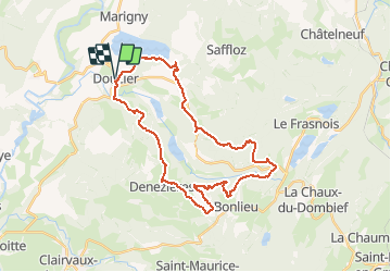
![](/images/other/stat-length.png)
![Trail Mountain bike Doucier - La Dame Blanche - Doucier - Photo](https://media.geolcdn.com/t/1900/400/ext.pjpeg?maxdim=2&url=https%3A%2F%2Fservices.sitytrail.com%2FGeolivesWS%2FDownloadMedia.ashx%3FTrailID%3D104084%26Media%3D7109_1.jpg)
La Dame Blanche - Doucier
tracegps
User
![Length](/images/other/stat-length.png)
![Max alt](https://static1.geolcdn.com/siteimages/upload/files/1508320355ic_sort_altitude_max_24dp.png)
![Uphill gradient](https://static1.geolcdn.com/siteimages/upload/files/1508320355ic_sort_den_pos_24dp.png)
![Km-Effort](/images/other/stat-length.png)
![Min alt](https://static1.geolcdn.com/siteimages/upload/files/1508320355ic_sort_altitude_min_24dp.png)
![Downhill gradient](https://static1.geolcdn.com/siteimages/upload/files/1508320355ic_sort_den_neg_24dp.png)
![Boucle](https://static1.geolcdn.com/siteimages/upload/files/16400158638029165_repeat_loop_refresh_sync_direction_icon.png)
![Mountain bike](https://static1.geolcdn.com/sitytour/trail-icons/202.png)
2h30
Difficulty : Difficult
![Scan this QR Code to open this trail in the SityTrail application](https://capi.geolives.com/qq0zvz2zws4bq2lad0pu/sitytour/trails/104084/qr.png?size=200)
FREE GPS app for hiking
About
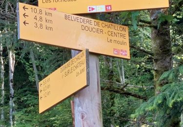
Trail Mountain bike of 33 km to be discovered at Bourgogne-Franche-Comté, Jura, Doucier. This trail is proposed by tracegps.
Description
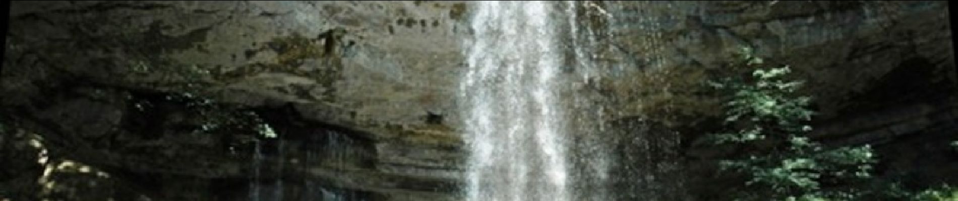
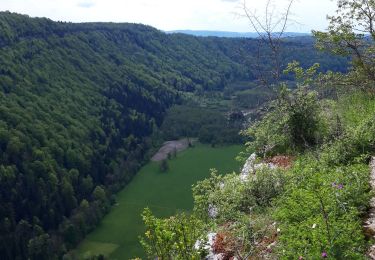
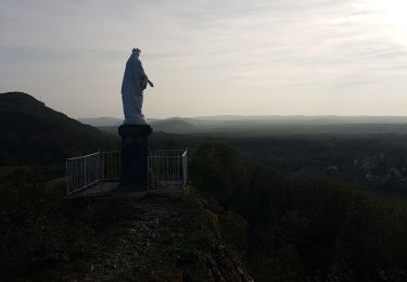
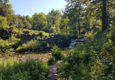
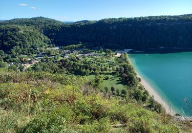
Beau circuit avec comme point d'orgue le belvédère de la Dame Blanche et un superbe point de vue sur la vallée et les cascades du Hérisson,et les belvédères au dessus du lac de Chalain. Très beau passage technique après la Dame Blanche et au dessus du lac de Chalain. Traversée du Hérisson au dessus des cascades.
Positioning
Comments
Trails nearby
![Trail Walking Menétrux-en-Joux - Les cascades du Hérisson : Boucle du randonneur - Photo](https://media.geolcdn.com/t/375/260/ext.jpg?maxdim=2&url=https%3A%2F%2Fservices.sitytrail.com%2FGeolivesWS%2FDownloadMedia.ashx%3FTrailID%3D792637%26Media%3Dfix__20170718143932.jpg)
![Walking Walking](https://static1.geolcdn.com/sitytour/trail-icons/101.png)
Walking
![](/images/other/stat-length.png)
![](https://static1.geolcdn.com/siteimages/upload/files/16400158638029165_repeat_loop_refresh_sync_direction_icon.png)
![Trail Walking Menétrux-en-Joux - Le Hérisson et ses cascades - Photo](https://media.geolcdn.com/t/375/260/ext.jpg?maxdim=2&url=https%3A%2F%2Fservices.sitytrail.com%2FGeolivesWS%2FDownloadMedia.ashx%3FTrailID%3D109457%26Media%3D3924_2.jpg)
![Walking Walking](https://static1.geolcdn.com/sitytour/trail-icons/101.png)
Walking
![](/images/other/stat-length.png)
![](https://static1.geolcdn.com/siteimages/upload/files/16400158638029165_repeat_loop_refresh_sync_direction_icon.png)
![Trail Horseback riding Menétrux-en-Joux - suuntoapp-HorsebackRiding-2024-05-19T07-42-52Z - Photo](https://media.geolcdn.com/t/375/260/e9e40113-5fdc-487c-81dd-3f92c59395a0.jpg&format=jpg&maxdim=2)
![Horseback riding Horseback riding](https://static1.geolcdn.com/sitytour/trail-icons/301.png)
Horseback riding
![](/images/other/stat-length.png)
![](https://static1.geolcdn.com/siteimages/upload/files/16400158638029165_repeat_loop_refresh_sync_direction_icon.png)
![Trail Horseback riding Menétrux-en-Joux - suuntoapp-HorsebackRiding-2024-05-18T07-33-28Z - Photo](https://media.geolcdn.com/t/375/260/afd7f6f4-ca7e-4782-8dbe-8cb940288a5d.jpg&format=jpg&maxdim=2)
![Horseback riding Horseback riding](https://static1.geolcdn.com/sitytour/trail-icons/301.png)
Horseback riding
![](/images/other/stat-length.png)
![](https://static1.geolcdn.com/siteimages/upload/files/16400158638029165_repeat_loop_refresh_sync_direction_icon.png)
![Trail Walking Menétrux-en-Joux - Menetrux. Les Cascades du hérisson. - Photo](https://media.geolcdn.com/t/375/260/8e5e2f86-bd6e-477f-a743-cdfd861bfcc6.jpg&format=jpg&maxdim=2)
![Walking Walking](https://static1.geolcdn.com/sitytour/trail-icons/101.png)
Walking
![](/images/other/stat-length.png)
![](https://static1.geolcdn.com/siteimages/upload/files/16400158638029165_repeat_loop_refresh_sync_direction_icon.png)
![Trail Walking Hauteroche - Mirebel avec Taïga - Photo](https://media.geolcdn.com/t/375/260/7abbcb78-a054-422a-acee-9b73230c2c5b.jpg&format=jpg&maxdim=2)
![Walking Walking](https://static1.geolcdn.com/sitytour/trail-icons/101.png)
Walking
![](/images/other/stat-length.png)
![](https://static1.geolcdn.com/siteimages/upload/files/16400158638029165_repeat_loop_refresh_sync_direction_icon.png)
![Trail Walking Menétrux-en-Joux - Ménétrux-en-Joux - cascades Evantail et Hérisson - Saut de la Forge - La Fromagerie - Photo](https://media.geolcdn.com/t/375/260/d48ed8df-2feb-4b91-8f37-fd07908921c0.jpg&format=jpg&maxdim=2)
![Walking Walking](https://static1.geolcdn.com/sitytour/trail-icons/101.png)
Walking
![](/images/other/stat-length.png)
![](https://static1.geolcdn.com/siteimages/upload/files/16400158638029165_repeat_loop_refresh_sync_direction_icon.png)
![Trail Walking Doucier - Balisage Lac de Chambly - Photo](https://media.geolcdn.com/t/375/260/a66299b1-acba-4c28-b135-ec0a9e2beef8.jpg&format=jpg&maxdim=2)
![Walking Walking](https://static1.geolcdn.com/sitytour/trail-icons/101.png)
Walking
![](/images/other/stat-length.png)
![](https://static1.geolcdn.com/siteimages/upload/files/16400158638029165_repeat_loop_refresh_sync_direction_icon.png)
![Trail Walking Fontenu - Tour du lac de Chalain - Photo](https://media.geolcdn.com/t/375/260/1c5595f4-5d36-4f85-b728-7ff9b046c0c9.jpg&format=jpg&maxdim=2)
![Walking Walking](https://static1.geolcdn.com/sitytour/trail-icons/101.png)
Walking
![](/images/other/stat-length.png)
![](https://static1.geolcdn.com/siteimages/upload/files/16400158638029165_repeat_loop_refresh_sync_direction_icon.png)