![](/images/other/stat-length.png)
![Trail Mountain bike Marolles - Rando La Marandolaise 2009 (45km) - Photo](https://media.geolcdn.com/t/1900/400/ext.pjpeg?maxdim=2&url=https%3A%2F%2Fstatic1.geolcdn.com%2Fsiteimages%2Fupload%2Ffiles%2F1524743154velo.jpg)
Rando La Marandolaise 2009 (45km)
tracegps
User
![Length](/images/other/stat-length.png)
Length
44 km
![Max alt](https://static1.geolcdn.com/siteimages/upload/files/1508320355ic_sort_altitude_max_24dp.png)
Max alt
190 m
![Uphill gradient](https://static1.geolcdn.com/siteimages/upload/files/1508320355ic_sort_den_pos_24dp.png)
Uphill gradient
745 m
![Km-Effort](/images/other/stat-length.png)
Km-Effort
54 km
![Min alt](https://static1.geolcdn.com/siteimages/upload/files/1508320355ic_sort_altitude_min_24dp.png)
Min alt
67 m
![Downhill gradient](https://static1.geolcdn.com/siteimages/upload/files/1508320355ic_sort_den_neg_24dp.png)
Downhill gradient
745 m
![Boucle](https://static1.geolcdn.com/siteimages/upload/files/16400158638029165_repeat_loop_refresh_sync_direction_icon.png)
Boucle
Yes
Creation date :
2014-12-10 00:00:00.0
Updated on :
2014-12-10 00:00:00.0
![Mountain bike](https://static1.geolcdn.com/sitytour/trail-icons/202.png)
3h00
Difficulty : Very difficult
![Scan this QR Code to open this trail in the SityTrail application](https://capi.geolives.com/qq0zvz2zws4bq2lad0pu/sitytour/trails/104049/qr.png?size=200)
FREE GPS app for hiking
About
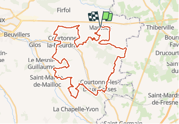
Trail Mountain bike of 44 km to be discovered at Normandy, Calvados, Marolles. This trail is proposed by tracegps.
Description
Départ : devant l'Église Très beau parcours proposé par l'équipe des vététistes de Marolles. Montées difficiles, descentes technique et grisantes... tout est réuni pour satisfaire les adeptes du tout terrain.
Positioning
Country:
France
Region :
Normandy
Department/Province :
Calvados
Municipality :
Marolles
Location:
Unknown
Start:(Dec)
Start:(UTM)
308371 ; 5446201 (31U) N.
Comments
Trails nearby
![Trail Walking Piencourt - Piencourt - Photo](https://media.geolcdn.com/t/375/260/ext.jpg?maxdim=2&url=https%3A%2F%2Fmedia.geolcdn.com%2Ff%2F4beea956-ee04-4f4b-a2c9-4c223ad3b55f.jpg)
![Walking Walking](https://static1.geolcdn.com/sitytour/trail-icons/101.png)
![Trail Walking Piencourt - Piencourt - Chemin des manoirs- 14,5 km - Photo](https://media.geolcdn.com/t/375/260/ext.jpg?maxdim=2&url=https%3A%2F%2Fmedia.geolcdn.com%2Ff%2F0019c7b3-7dcb-4974-97af-1ad73c45110f.jpg)
![Walking Walking](https://static1.geolcdn.com/sitytour/trail-icons/101.png)
Piencourt - Chemin des manoirs- 14,5 km
Walking
Very easy
Piencourt,
Normandy,
Eure,
France
![](/images/other/stat-length.png)
14.5 km | 16.5 km-effort
4h 56min
![](https://static1.geolcdn.com/siteimages/upload/files/16400158638029165_repeat_loop_refresh_sync_direction_icon.png)
Yes
![Trail Other activity La Chapelle-Hareng - La chapelle Hareng - Photo](https://media.geolcdn.com/t/375/260/ext.jpg?maxdim=2&url=https%3A%2F%2Fstatic1.geolcdn.com%2Fsiteimages%2Fupload%2Ffiles%2F1545311037marcheuse_200dpi.jpg)
![Other activity Other activity](https://static1.geolcdn.com/sitytour/trail-icons/900.png)
La chapelle Hareng
Other activity
Very easy
(1)
La Chapelle-Hareng,
Normandy,
Eure,
France
![](/images/other/stat-length.png)
6.1 km | 7.1 km-effort
1h 40min
![](https://static1.geolcdn.com/siteimages/upload/files/16400158638029165_repeat_loop_refresh_sync_direction_icon.png)
No
![Trail Walking Ouilly-du-Houley - Ouille du Houley - Photo](https://media.geolcdn.com/t/375/260/ext.jpg?maxdim=2&url=https%3A%2F%2Fmedia.geolcdn.com%2Ff%2Fcd9905a5-9c9c-429d-a6f8-8fbab83e7196.jpg)
![Walking Walking](https://static1.geolcdn.com/sitytour/trail-icons/101.png)
Ouille du Houley
Walking
Medium
(1)
Ouilly-du-Houley,
Normandy,
Calvados,
France
![](/images/other/stat-length.png)
11.3 km | 14.4 km-effort
3h 9min
![](https://static1.geolcdn.com/siteimages/upload/files/16400158638029165_repeat_loop_refresh_sync_direction_icon.png)
Yes
![Trail Walking Fumichon - Fumichon - Photo](https://media.geolcdn.com/t/375/260/ext.jpg?maxdim=2&url=https%3A%2F%2Fmedia.geolcdn.com%2Ff%2Fbe9d2533-06e1-4acc-b8b0-fc7888a7b2e6.jpg)
![Walking Walking](https://static1.geolcdn.com/sitytour/trail-icons/101.png)
Fumichon
Walking
Medium
(1)
Fumichon,
Normandy,
Calvados,
France
![](/images/other/stat-length.png)
13.9 km | 16.4 km-effort
2h 43min
![](https://static1.geolcdn.com/siteimages/upload/files/16400158638029165_repeat_loop_refresh_sync_direction_icon.png)
Yes
![Trail Walking La Chapelle-Hareng - chemin de la Baronniere - Photo](https://media.geolcdn.com/t/375/260/ext.jpg?maxdim=2&url=https%3A%2F%2Fmedia.geolcdn.com%2Ff%2F2101887b-5f22-442c-a91f-77143c200a36.jpg)
![Walking Walking](https://static1.geolcdn.com/sitytour/trail-icons/101.png)
chemin de la Baronniere
Walking
Easy
La Chapelle-Hareng,
Normandy,
Eure,
France
![](/images/other/stat-length.png)
6.6 km | 7.7 km-effort
1h 31min
![](https://static1.geolcdn.com/siteimages/upload/files/16400158638029165_repeat_loop_refresh_sync_direction_icon.png)
Yes
![Trail Walking La Chapelle-Hareng - Chemin de la Fontaine au Dragon - La Chapelle-Hareng - Photo](https://media.geolcdn.com/t/375/260/ext.jpg?maxdim=2&url=https%3A%2F%2Fservices.sitytrail.com%2FGeolivesWS%2FDownloadMedia.ashx%3FTrailID%3D110482%26Media%3D6000_1.jpg)
![Walking Walking](https://static1.geolcdn.com/sitytour/trail-icons/101.png)
Chemin de la Fontaine au Dragon - La Chapelle-Hareng
Walking
Difficult
La Chapelle-Hareng,
Normandy,
Eure,
France
![](/images/other/stat-length.png)
15.8 km | 17.3 km-effort
4h 0min
![](https://static1.geolcdn.com/siteimages/upload/files/16400158638029165_repeat_loop_refresh_sync_direction_icon.png)
Yes
![Trail Walking La Chapelle-Hareng - Chemin de la Baronnière - La Chapelle-Hareng - Photo](https://media.geolcdn.com/t/375/260/ext.jpg?maxdim=2&url=https%3A%2F%2Fservices.sitytrail.com%2FGeolivesWS%2FDownloadMedia.ashx%3FTrailID%3D110472%26Media%3D5988_1.jpg)
![Walking Walking](https://static1.geolcdn.com/sitytour/trail-icons/101.png)
Chemin de la Baronnière - La Chapelle-Hareng
Walking
Easy
La Chapelle-Hareng,
Normandy,
Eure,
France
![](/images/other/stat-length.png)
6.3 km | 7.3 km-effort
1h 34min
![](https://static1.geolcdn.com/siteimages/upload/files/16400158638029165_repeat_loop_refresh_sync_direction_icon.png)
Yes
![Trail Walking Piencourt - Chemin des Fontaines Paquin - Piencourt - Photo](https://media.geolcdn.com/t/375/260/ext.jpg?maxdim=2&url=https%3A%2F%2Fservices.sitytrail.com%2FGeolivesWS%2FDownloadMedia.ashx%3FTrailID%3D110447%26Media%3D5937_2.jpg)
![Walking Walking](https://static1.geolcdn.com/sitytour/trail-icons/101.png)
Chemin des Fontaines Paquin - Piencourt
Walking
Medium
Piencourt,
Normandy,
Eure,
France
![](/images/other/stat-length.png)
9.3 km | 10.3 km-effort
2h 19min
![](https://static1.geolcdn.com/siteimages/upload/files/16400158638029165_repeat_loop_refresh_sync_direction_icon.png)
Yes