![](/images/other/stat-length.png)
![Trail Walking Rennes-les-Bains - Rennes les Bains - Photo](https://media.geolcdn.com/t/1900/400/ext.pjpeg?maxdim=2&url=https%3A%2F%2Fservices.sitytrail.com%2FGeolivesWS%2FDownloadMedia.ashx%3FTrailID%3D104019%26Media%3D6975_3.jpg)
Rennes les Bains
tracegps
User
![Length](/images/other/stat-length.png)
![Max alt](https://static1.geolcdn.com/siteimages/upload/files/1508320355ic_sort_altitude_max_24dp.png)
![Uphill gradient](https://static1.geolcdn.com/siteimages/upload/files/1508320355ic_sort_den_pos_24dp.png)
![Km-Effort](/images/other/stat-length.png)
![Min alt](https://static1.geolcdn.com/siteimages/upload/files/1508320355ic_sort_altitude_min_24dp.png)
![Downhill gradient](https://static1.geolcdn.com/siteimages/upload/files/1508320355ic_sort_den_neg_24dp.png)
![Boucle](https://static1.geolcdn.com/siteimages/upload/files/16400158638029165_repeat_loop_refresh_sync_direction_icon.png)
![Walking](https://static1.geolcdn.com/sitytour/trail-icons/101.png)
4h00
Difficulty : Difficult
![Scan this QR Code to open this trail in the SityTrail application](https://capi.geolives.com/qq0zvz2zws4bq2lad0pu/sitytour/trails/104019/qr.png?size=200)
FREE GPS app for hiking
About
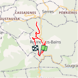
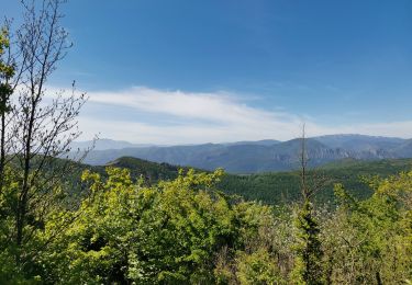
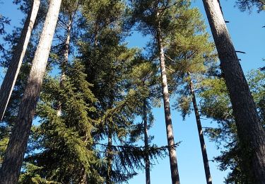
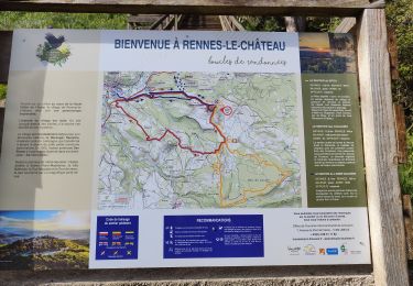
Trail Walking of 12.4 km to be discovered at Occitania, Aude, Rennes-les-Bains. This trail is proposed by tracegps.
Description
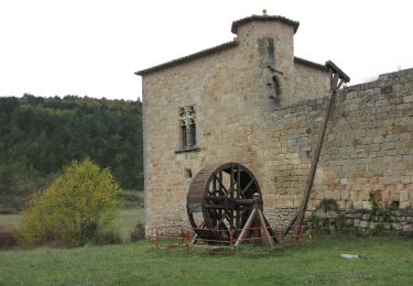
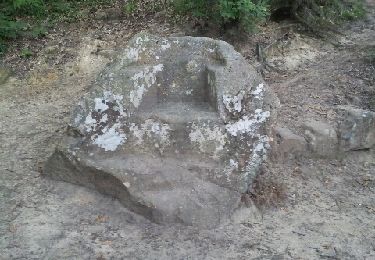
Garer la voiture sur le parking face à l'office de tourisme de Rennes les Bains, parcourir la rue principale jusqu'à la mairie, prendre le chemin en face direction la Cabanasse, Château de Blanchefort. A l'embranchement la Cabanasse,Château de Blanchefort, un aller retour (1h45) en direction Château de Blanchefort permet d'atteindre le pod (l'accès aux ruines nécessite quelques pas d'escalade),de retour à l'embranchement prendre la direction de la Cabanasse, passer cette campagne, poursuivre le chemin qui rejoint une large piste, la suivre jusqu'à l'embranchement roches tremblantes,chaise du diable, suivre la direction roches tremblantes, après la visite aux roches tremblantes, revenir sur Rennes les Bains par le fauteuil du Diable, le cercle. Un aller retour le long de la rivière Salz (10mn) permet de voir le moulin du cercle. Retour au point de départ rive droite de la Salz.
Positioning
Comments
Trails nearby
![Trail Walking Bugarach - Le Pech de Bugarach - Photo](https://media.geolcdn.com/t/375/260/ext.jpg?maxdim=2&url=https%3A%2F%2Fservices.sitytrail.com%2FGeolivesWS%2FDownloadMedia.ashx%3FTrailID%3D103373%26Media%3D5434_4.jpg)
![Walking Walking](https://static1.geolcdn.com/sitytour/trail-icons/101.png)
Walking
![](/images/other/stat-length.png)
![](https://static1.geolcdn.com/siteimages/upload/files/16400158638029165_repeat_loop_refresh_sync_direction_icon.png)
![Trail Cycle Arques - CCS FFC Aude en Pyrénées - Circuit n°11 - Arques - Photo](https://media.geolcdn.com/t/375/260/ext.jpg?maxdim=2&url=https%3A%2F%2Fservices.sitytrail.com%2FGeolivesWS%2FDownloadMedia.ashx%3FTrailID%3D111470%26Media%3D7353_1.jpg)
![Cycle Cycle](https://static1.geolcdn.com/sitytour/trail-icons/200.png)
Cycle
![](/images/other/stat-length.png)
![](https://static1.geolcdn.com/siteimages/upload/files/16400158638029165_repeat_loop_refresh_sync_direction_icon.png)
![Trail Walking Serres - Serres Cardou - Photo](https://media.geolcdn.com/t/375/260/3dcdcfad-e675-4328-969d-93b02c6e2d21.jpg&format=jpg&maxdim=2)
![Walking Walking](https://static1.geolcdn.com/sitytour/trail-icons/101.png)
![Trail On foot Arques - La Frau - Photo](https://media.geolcdn.com/t/375/260/dd7678c6-a794-444d-a52c-e2d60c9d9291.jpeg&format=jpg&maxdim=2)
![On foot On foot](https://static1.geolcdn.com/sitytour/trail-icons/100.png)
![Trail On foot Arques - Les Berques - Photo](https://media.geolcdn.com/t/375/260/84344748-6b6d-47a0-bbe7-d97839fec542.jpeg&format=jpg&maxdim=2)
![On foot On foot](https://static1.geolcdn.com/sitytour/trail-icons/100.png)
![Trail Walking Bugarach - Bugarach par la fenêtre - Photo](https://media.geolcdn.com/t/375/260/f61c8120-4edd-4c37-b8d1-8f8539bc9df7.jpg&format=jpg&maxdim=2)
![Walking Walking](https://static1.geolcdn.com/sitytour/trail-icons/101.png)
Walking
![](/images/other/stat-length.png)
![](https://static1.geolcdn.com/siteimages/upload/files/16400158638029165_repeat_loop_refresh_sync_direction_icon.png)
![Trail Walking Arques - Arques 29 09 3019 - Photo](https://media.geolcdn.com/t/375/260/d8261a14-6ebe-438a-a45c-071567d1fc57.jpg&format=jpg&maxdim=2)
![Walking Walking](https://static1.geolcdn.com/sitytour/trail-icons/101.png)
Walking
![](/images/other/stat-length.png)
![](https://static1.geolcdn.com/siteimages/upload/files/16400158638029165_repeat_loop_refresh_sync_direction_icon.png)
![Trail Walking Rennes-les-Bains - Sources Rennes les bains - Photo](https://media.geolcdn.com/t/375/260/ext.jpg?maxdim=2&url=https%3A%2F%2Fservices.sitytrail.com%2FGeolivesWS%2FDownloadMedia.ashx%3FTrailID%3D139042%26Media%3D20120625205934.jpeg)
![Walking Walking](https://static1.geolcdn.com/sitytour/trail-icons/101.png)
Walking
![](/images/other/stat-length.png)
![](https://static1.geolcdn.com/siteimages/upload/files/16400158638029165_repeat_loop_refresh_sync_direction_icon.png)
![Trail Walking Rennes-le-Château - Rennes le Château - Photo](https://media.geolcdn.com/t/375/260/1a7a8025-e376-4adf-91ac-565091fd51c9.jpg&format=jpg&maxdim=2)
![Walking Walking](https://static1.geolcdn.com/sitytour/trail-icons/101.png)
Walking
![](/images/other/stat-length.png)
![](https://static1.geolcdn.com/siteimages/upload/files/16400158638029165_repeat_loop_refresh_sync_direction_icon.png)