![](/images/other/stat-length.png)
![Trail Walking Etxalar - Zentinela depuis le Col de Lizarieta - Photo](https://media.geolcdn.com/t/1900/400/ext.pjpeg?maxdim=2&url=https%3A%2F%2Fstatic1.geolcdn.com%2Fsiteimages%2Fupload%2Ffiles%2F1553511878bg_sport_marche.png)
Zentinela depuis le Col de Lizarieta
georgein
User
![Length](/images/other/stat-length.png)
Length
12.9 km
![Max alt](https://static1.geolcdn.com/siteimages/upload/files/1508320355ic_sort_altitude_max_24dp.png)
Max alt
671 m
![Uphill gradient](https://static1.geolcdn.com/siteimages/upload/files/1508320355ic_sort_den_pos_24dp.png)
Uphill gradient
524 m
![Km-Effort](/images/other/stat-length.png)
Km-Effort
19.9 km
![Min alt](https://static1.geolcdn.com/siteimages/upload/files/1508320355ic_sort_altitude_min_24dp.png)
Min alt
385 m
![Downhill gradient](https://static1.geolcdn.com/siteimages/upload/files/1508320355ic_sort_den_neg_24dp.png)
Downhill gradient
523 m
![Boucle](https://static1.geolcdn.com/siteimages/upload/files/16400158638029165_repeat_loop_refresh_sync_direction_icon.png)
Boucle
Yes
Creation date :
2019-08-04 09:20:31.195
Updated on :
2020-01-31 20:30:01.995
![Walking](https://static1.geolcdn.com/sitytour/trail-icons/101.png)
4h07
Difficulty : Unknown
![Scan this QR Code to open this trail in the SityTrail application](https://capi.geolives.com/qq0zvz2zws4bq2lad0pu/sitytour/trails/1040050/qr.png?size=200)
FREE GPS app for hiking
About
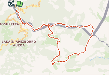
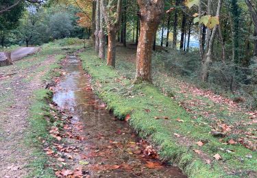
Trail Walking of 12.9 km to be discovered at Navarre, Unknown, Etxalar. This trail is proposed by georgein.
Description
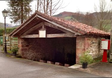
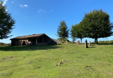
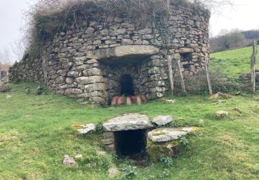
Belle randonnée permettant de profiter de vues superbes sur les sommets alentours ainsi que sur l'océan au loin.
De plus, vous traverserez un site archéologique émouvant
Points of interest
Positioning
Country:
Spain
Region :
Navarre
Department/Province :
Unknown
Municipality :
Etxalar
Location:
Unknown
Start:(Dec)
Start:(UTM)
612093 ; 4790658 (30T) N.
Comments
Trails nearby
![Trail On foot Etxalar - SL-NA 5 Argarata - Santa Krutz - Photo](https://media.geolcdn.com/t/375/260/94bbb8c0-a5b3-4c45-bc43-34bd6d9df6cd.jpeg&format=jpg&maxdim=2)
![On foot On foot](https://static1.geolcdn.com/sitytour/trail-icons/100.png)
SL-NA 5 Argarata - Santa Krutz
On foot
Easy
Etxalar,
Navarre,
Unknown,
Spain
![](/images/other/stat-length.png)
4.5 km | 5.7 km-effort
1h 17min
![](https://static1.geolcdn.com/siteimages/upload/files/16400158638029165_repeat_loop_refresh_sync_direction_icon.png)
Yes
![Trail Walking Sare - La rhune par la face EST - Photo](https://media.geolcdn.com/t/375/260/ext.jpg?maxdim=2&url=https%3A%2F%2Fstatic1.geolcdn.com%2Fsiteimages%2Fupload%2Ffiles%2F1553511878bg_sport_marche.png)
![Walking Walking](https://static1.geolcdn.com/sitytour/trail-icons/101.png)
La rhune par la face EST
Walking
Medium
(1)
Sare,
New Aquitaine,
Pyrénées-Atlantiques,
France
![](/images/other/stat-length.png)
13.8 km | 26 km-effort
5h 10min
![](https://static1.geolcdn.com/siteimages/upload/files/16400158638029165_repeat_loop_refresh_sync_direction_icon.png)
Yes
![Trail Walking Sare - sare les palombieres - Photo](https://media.geolcdn.com/t/375/260/ext.jpg?maxdim=2&url=https%3A%2F%2Fservices.sitytrail.com%2FGeolivesWS%2FDownloadMedia.ashx%3FTrailID%3D226934%26Media%3D20131002143837.jpg)
![Walking Walking](https://static1.geolcdn.com/sitytour/trail-icons/101.png)
sare les palombieres
Walking
Easy
Sare,
New Aquitaine,
Pyrénées-Atlantiques,
France
![](/images/other/stat-length.png)
15.8 km | 24 km-effort
4h 44min
![](https://static1.geolcdn.com/siteimages/upload/files/16400158638029165_repeat_loop_refresh_sync_direction_icon.png)
Yes
![Trail Walking Sare - atxuria zugaramurdi - Photo](https://media.geolcdn.com/t/375/260/ext.jpg?maxdim=2&url=https%3A%2F%2Fstatic1.geolcdn.com%2Fsiteimages%2Fupload%2Ffiles%2F1553511878bg_sport_marche.png)
![Walking Walking](https://static1.geolcdn.com/sitytour/trail-icons/101.png)
atxuria zugaramurdi
Walking
Very easy
(3)
Sare,
New Aquitaine,
Pyrénées-Atlantiques,
France
![](/images/other/stat-length.png)
10.3 km | 18.7 km-effort
3h 50min
![](https://static1.geolcdn.com/siteimages/upload/files/16400158638029165_repeat_loop_refresh_sync_direction_icon.png)
Yes
![Trail Walking Sare - Lizarieta descente par palombieres - Photo](https://media.geolcdn.com/t/375/260/9d6ad3d3-a9ac-4160-b5e2-482251e1a583.jpg&format=jpg&maxdim=2)
![Walking Walking](https://static1.geolcdn.com/sitytour/trail-icons/101.png)
Lizarieta descente par palombieres
Walking
Very easy
Sare,
New Aquitaine,
Pyrénées-Atlantiques,
France
![](/images/other/stat-length.png)
8.9 km | 11.9 km-effort
2h 49min
![](https://static1.geolcdn.com/siteimages/upload/files/16400158638029165_repeat_loop_refresh_sync_direction_icon.png)
No
![Trail Walking Sare - col de lizarrieta et col des 3 bornes - Photo](https://media.geolcdn.com/t/375/260/4a8eca64-9908-469c-ac1f-6551c3878583.jpg&format=jpg&maxdim=2)
![Walking Walking](https://static1.geolcdn.com/sitytour/trail-icons/101.png)
col de lizarrieta et col des 3 bornes
Walking
Difficult
Sare,
New Aquitaine,
Pyrénées-Atlantiques,
France
![](/images/other/stat-length.png)
13 km | 18.5 km-effort
3h 45min
![](https://static1.geolcdn.com/siteimages/upload/files/16400158638029165_repeat_loop_refresh_sync_direction_icon.png)
Yes
![Trail Walking Sare - Lizarrieta, Zentinel, col des 3 bornes, 2024 03 04. - Photo](https://media.geolcdn.com/t/375/260/8ac35c6d-8e84-4286-9748-27c916c27140.jpg&format=jpg&maxdim=2)
![Walking Walking](https://static1.geolcdn.com/sitytour/trail-icons/101.png)
Lizarrieta, Zentinel, col des 3 bornes, 2024 03 04.
Walking
Difficult
Sare,
New Aquitaine,
Pyrénées-Atlantiques,
France
![](/images/other/stat-length.png)
12.4 km | 17.8 km-effort
4h 3min
![](https://static1.geolcdn.com/siteimages/upload/files/16400158638029165_repeat_loop_refresh_sync_direction_icon.png)
Yes
![Trail Walking Sare - Palombieres ibantelli - Photo](https://media.geolcdn.com/t/375/260/76acc27f-1655-4a4b-967e-18a83da8848a.jpg&format=jpg&maxdim=2)
![Walking Walking](https://static1.geolcdn.com/sitytour/trail-icons/101.png)
Palombieres ibantelli
Walking
Easy
Sare,
New Aquitaine,
Pyrénées-Atlantiques,
France
![](/images/other/stat-length.png)
14.8 km | 0 m-effort
5h 6min
![](https://static1.geolcdn.com/siteimages/upload/files/16400158638029165_repeat_loop_refresh_sync_direction_icon.png)
Yes
![Trail Walking Sare - Atxuria tour par zugaramurdi - Photo](https://media.geolcdn.com/t/375/260/3066bfa2-9b4e-4a27-8cc8-e3c2b1a385fe.jpg&format=jpg&maxdim=2)
![Walking Walking](https://static1.geolcdn.com/sitytour/trail-icons/101.png)
Atxuria tour par zugaramurdi
Walking
Easy
Sare,
New Aquitaine,
Pyrénées-Atlantiques,
France
![](/images/other/stat-length.png)
14.7 km | 24 km-effort
4h 43min
![](https://static1.geolcdn.com/siteimages/upload/files/16400158638029165_repeat_loop_refresh_sync_direction_icon.png)
Yes