Trail Walking Givenchy-le-Noble - Givenchy le Noble - Ambrines - Denier - Lignereuil - Photo

Givenchy le Noble - Ambrines - Denier - Lignereuil

 tracegps
tracegps

User

© OpenStreetMap contributors
Length
Length
11 km
Max alt
Max alt
154 m
Uphill gradient
Uphill gradient
109 m
Km-Effort
Km-Effort  
12.5 km
Min alt
Min alt
103 m
Downhill gradient
Downhill gradient
106 m
Boucle
Boucle
Yes
Creation date :
2014-12-10 00:00:00.0
Updated on :
2014-12-10 00:00:00.0

(0 Reviews)

Walking
Walking
2h00
Difficulty : Medium

Scan this QR Code to open this trail in the SityTrail application

FREE GPS app for hiking

Logo SityTrail SityTrail

IGN / Geographical institutes

Download SityTrail from the App Store Download SityTrail from Google Play

Logo SityTrail SityTrail World

The world is yours!

Download SityTrail from the App Store Download SityTrail from Google Play Download SityTrail on Huawei AppGallery

About

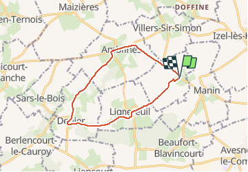
Trail Walking of 11 km to be discovered at Hauts-de-France, Pas-de-Calais, Givenchy-le-Noble. This trail is proposed by tracegps.

Description

Belle randonnée au départ d'un château et qui emprunte une allée magnifique bordée d'une double rangée de tilleuls entre deux châteaux Lignereuil et Givenchy.

Elevation profile

Photos

Points of interest

Point of interest Givenchy-le-Noble - WP 1 - Photo
tracegps
GIVENCHY-LE-NOBLE 
Point of interest Givenchy-le-Noble - WP 2 - Photo
tracegps
GIVENCHY-LE-NOBLE 

Positioning

Country:
France
Region :
Hauts-de-France
Department/Province :
Pas-de-Calais
Municipality :
Givenchy-le-Noble
Location:
Unknown
Start:(UTM)
464260 ; 5572227 (31U) N.

Trails nearby

Trail Mountain bike Avesnes-le-Comte - Les 6 châteaux - Avesnes le Comte - Photo
Mountain bike
tracegps

Mountain bike

Difficult
(1)
Avesnes-le-Comte, Hauts-de-France, Pas-de-Calais, France
44 km | 50 km-effort
2h 10min
Yes
Trail Mountain bike Fosseux - Lucheux - Photo
Mountain bike
tracegps

Mountain bike

Medium
(2)
Fosseux, Hauts-de-France, Pas-de-Calais, France
44 km | 50 km-effort
3h 0min
Yes
Trail Walking Penin - Chemin des piedsentes  (Penin) - Photo
Walking
tracegps

Walking

Difficult
Penin, Hauts-de-France, Pas-de-Calais, France
14.5 km | 15.7 km-effort
3h 40min
Yes
Trail Walking Lignereuil - LIGNEREUIL (62) - Par le bois du Fay - Photo
Walking
temmichel

Walking

Difficult
Lignereuil, Hauts-de-France, Pas-de-Calais, France
12.1 km | 13.5 km-effort
3h 4min
Yes
Trail Walking Avesnes-le-Comte - Avesnes le Comte, Noyelle-Vion, Manin, Beaufort-Blavincourt - Photo
Walking
tracegps

Walking

Medium
Avesnes-le-Comte, Hauts-de-France, Pas-de-Calais, France
10.8 km | 12.2 km-effort
2h 30min
Yes
Trail Walking Lignereuil - Lignereuil Allée des tilleuls - Blavincourt - Denier - Photo
Walking
tracegps

Walking

Medium
Lignereuil, Hauts-de-France, Pas-de-Calais, France
11.2 km | 12.7 km-effort
2h 0min
Yes
Trail Mountain bike Avesnes-le-Comte - Les six châteaux - Photo
Mountain bike
Gilbert62580

Mountain bike

Medium
Avesnes-le-Comte, Hauts-de-France, Pas-de-Calais, France
44 km | 50 km-effort
Unknown
Yes
Trail Walking Averdoingt - Rando1402 - Photo
Walking
Michael Pruvost

Walking

Averdoingt, Hauts-de-France, Pas-de-Calais, France
12.1 km | 13 km-effort
2h 7min
Yes
Trail Walking Averdoingt - RANDO 2 - Photo
Walking
Michael Pruvost

Walking

Averdoingt, Hauts-de-France, Pas-de-Calais, France
10.3 km | 11.5 km-effort
1h 58min
No


Close
My subscriptions