![](/images/other/stat-length.png)
![Trail Mountain bike Bruz - VTT Bruz - Chartres de Bretagne - Orgères - 30km - Photo](https://media.geolcdn.com/t/1900/400/ext.pjpeg?maxdim=2&url=https%3A%2F%2Fstatic1.geolcdn.com%2Fsiteimages%2Fupload%2Ffiles%2F1524743154velo.jpg)
VTT Bruz - Chartres de Bretagne - Orgères - 30km
tracegps
User
![Length](/images/other/stat-length.png)
![Max alt](https://static1.geolcdn.com/siteimages/upload/files/1508320355ic_sort_altitude_max_24dp.png)
![Uphill gradient](https://static1.geolcdn.com/siteimages/upload/files/1508320355ic_sort_den_pos_24dp.png)
![Km-Effort](/images/other/stat-length.png)
![Min alt](https://static1.geolcdn.com/siteimages/upload/files/1508320355ic_sort_altitude_min_24dp.png)
![Downhill gradient](https://static1.geolcdn.com/siteimages/upload/files/1508320355ic_sort_den_neg_24dp.png)
![Boucle](https://static1.geolcdn.com/siteimages/upload/files/16400158638029165_repeat_loop_refresh_sync_direction_icon.png)
![Mountain bike](https://static1.geolcdn.com/sitytour/trail-icons/202.png)
2h30
Difficulty : Medium
![Scan this QR Code to open this trail in the SityTrail application](https://capi.geolives.com/qq0zvz2zws4bq2lad0pu/sitytour/trails/103941/qr.png?size=200)
FREE GPS app for hiking
About
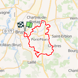
Trail Mountain bike of 27 km to be discovered at Brittany, Ille-et-Vilaine, Bruz. This trail is proposed by tracegps.
Description
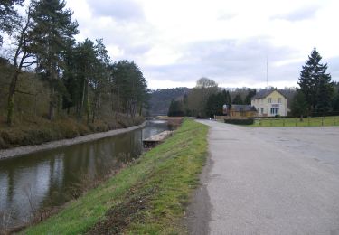
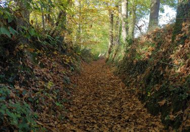
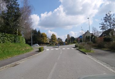
Circuit VTT de moyenne difficulté: va du très facile au technique. Passage près de la Clinique du Moulin : bien suivre le GR qui traverse la route. A partir de là, 1er petit passage technique : petite côte. Ensuite sentier très facile jusqu'à Chartres de Bretagne. Passage de Chartres sans intérêt, le mieux serait de couper au Sud de Chartres. Du coté de la piscine de la Conterie, ne pas prendre le 1er sentier qui longe la piscine qui atterrit dans un cul de sac mais prendre la piste cyclable qui longe la 4 voies. Par la suite succession de passage en sentier, plat, aucune difficulté. En arrivant à Orgères, allez jusqu'au 1er stade de foot et prendre immédiatement à droite le sentier qui borde le champ. Au niveau du stade en stabilisé, un sentier part à droite, très agréable. On rejoint alors l'église par une petite montée assez raide. A l'église prendre immédiatement à droite. Entrée dans la forêt, très agréable, un petit tronçon en descente intéressant, attention aux feuilles d'automne qui masquent le sentier. Suivre ensuite le circuit de "La Roche qui chome". Quelques passages techniques, car le sentier est pavé de grosses pierres bien vertes : attention aux glissades en temps de pluie. On retombe vers la fin sur le GR39 qui nous ramène au bercail.
Positioning
Comments
Trails nearby
![Trail Mountain bike Pont-Péan - Le long de la Vilaine - Pont Péan - Photo](https://media.geolcdn.com/t/375/260/ext.jpg?maxdim=2&url=https%3A%2F%2Fservices.sitytrail.com%2FGeolivesWS%2FDownloadMedia.ashx%3FTrailID%3D214889%26Media%3D15441_3.jpg)
![Mountain bike Mountain bike](https://static1.geolcdn.com/sitytour/trail-icons/202.png)
Mountain bike
![](/images/other/stat-length.png)
![](https://static1.geolcdn.com/siteimages/upload/files/16400158638029165_repeat_loop_refresh_sync_direction_icon.png)
![Trail Walking Pont-Péan - Randonnée autour de Pont-Péan - Photo](https://media.geolcdn.com/t/375/260/ext.jpg?maxdim=2&url=https%3A%2F%2Fservices.sitytrail.com%2FGeolivesWS%2FDownloadMedia.ashx%3FTrailID%3D191361%26Media%3D14926_3.jpg)
![Walking Walking](https://static1.geolcdn.com/sitytour/trail-icons/101.png)
Walking
![](/images/other/stat-length.png)
![](https://static1.geolcdn.com/siteimages/upload/files/16400158638029165_repeat_loop_refresh_sync_direction_icon.png)
![Trail On foot Laillé - Laillé la Chapelle - Photo](https://media.geolcdn.com/t/375/260/80425336-5829-4a9b-bf94-af8dc6722242.jpeg&format=jpg&maxdim=2)
![On foot On foot](https://static1.geolcdn.com/sitytour/trail-icons/100.png)
On foot
![](/images/other/stat-length.png)
![](https://static1.geolcdn.com/siteimages/upload/files/16400158638029165_repeat_loop_refresh_sync_direction_icon.png)
![Trail On foot Guichen - Les landes du Boël - Photo](https://media.geolcdn.com/t/375/260/1813c78e-bc32-4e6c-94ee-9a2d64ec30b9.jpeg&format=jpg&maxdim=2)
![On foot On foot](https://static1.geolcdn.com/sitytour/trail-icons/100.png)
On foot
![](/images/other/stat-length.png)
![](https://static1.geolcdn.com/siteimages/upload/files/16400158638029165_repeat_loop_refresh_sync_direction_icon.png)
![Trail On foot Guichen - Les bords de Vilaine - Photo](https://media.geolcdn.com/t/375/260/8b284707-f183-43bc-8580-95dab992180f.jpeg&format=jpg&maxdim=2)
![On foot On foot](https://static1.geolcdn.com/sitytour/trail-icons/100.png)
On foot
![](/images/other/stat-length.png)
![](https://static1.geolcdn.com/siteimages/upload/files/16400158638029165_repeat_loop_refresh_sync_direction_icon.png)
![Trail On foot Guichen - Pont-Réan Le Boël - Photo](https://media.geolcdn.com/t/375/260/e213902f-f4f2-441e-8674-df4f61e7aed3.jpeg&format=jpg&maxdim=2)
![On foot On foot](https://static1.geolcdn.com/sitytour/trail-icons/100.png)
On foot
![](/images/other/stat-length.png)
![](https://static1.geolcdn.com/siteimages/upload/files/16400158638029165_repeat_loop_refresh_sync_direction_icon.png)
![Trail Walking Laillé - Laillé, Roche qui chome - Photo](https://media.geolcdn.com/t/375/260/420863b8-58d5-4ae8-816c-3f076cdd0c92.jpg&format=jpg&maxdim=2)
![Walking Walking](https://static1.geolcdn.com/sitytour/trail-icons/101.png)
Walking
![](/images/other/stat-length.png)
![](https://static1.geolcdn.com/siteimages/upload/files/16400158638029165_repeat_loop_refresh_sync_direction_icon.png)
![Trail On foot Orgères - Circuit des deux Monts et du Télégraphe - Photo](https://media.geolcdn.com/t/375/260/610afbfe-2a2c-4336-a051-18e768a6f818.jpeg&format=jpg&maxdim=2)
![On foot On foot](https://static1.geolcdn.com/sitytour/trail-icons/100.png)
On foot
![](/images/other/stat-length.png)
![](https://static1.geolcdn.com/siteimages/upload/files/16400158638029165_repeat_loop_refresh_sync_direction_icon.png)
![Trail Walking Guichen - pont rean - Photo](https://media.geolcdn.com/t/375/260/65f98fc0-d3d5-4bdf-9405-7defdae3d94b.jpg&format=jpg&maxdim=2)
![Walking Walking](https://static1.geolcdn.com/sitytour/trail-icons/101.png)
Walking
![](/images/other/stat-length.png)
![](https://static1.geolcdn.com/siteimages/upload/files/16400158638029165_repeat_loop_refresh_sync_direction_icon.png)