Trail Mountain bike Condé-en-Normandie - Condé sur Noireau - Pont d'Ouilly - Photo

Condé sur Noireau - Pont d'Ouilly

 tracegps
tracegps

User

© OpenStreetMap contributors
Length
Length
46 km
Max alt
Max alt
241 m
Uphill gradient
Uphill gradient
1082 m
Km-Effort
Km-Effort  
60 km
Min alt
Min alt
48 m
Downhill gradient
Downhill gradient
1082 m
Boucle
Boucle
Yes
Creation date :
2014-12-10 00:00:00.0
Updated on :
2014-12-10 00:00:00.0

(0 Reviews)

Mountain bike
Mountain bike
3h00
Difficulty : Difficult

Scan this QR Code to open this trail in the SityTrail application

FREE GPS app for hiking

Logo SityTrail SityTrail

IGN / Geographical institutes

Download SityTrail from the App Store Download SityTrail from Google Play

Logo SityTrail SityTrail World

The world is yours!

Download SityTrail from the App Store Download SityTrail from Google Play Download SityTrail on Huawei AppGallery

About

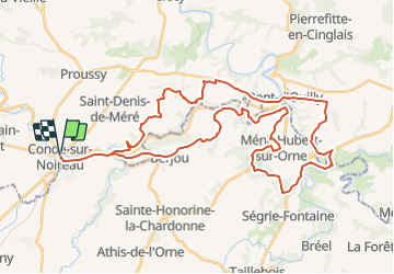
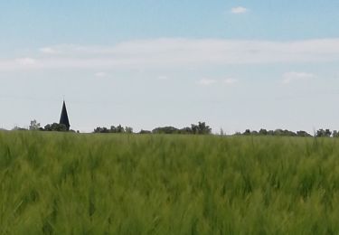
Trail Mountain bike of 46 km to be discovered at Normandy, Calvados, Condé-en-Normandie. This trail is proposed by tracegps.

Description

Rando organisée le 10/10/09 par le SLSN de Condé sur Noireau (Sports et Loisirs en Suisse Normande). Superbe rando tant au niveau technique qu'au niveau des paysages de la suisse Normande. Casque obligatoire et indispensable !

Elevation profile

Positioning

Country:
France
Region :
Normandy
Department/Province :
Calvados
Municipality :
Condé-en-Normandie
Location:
Unknown
Start:(UTM)
679674 ; 5413709 (30U) N.

Trails nearby

Trail Mountain bike Athis-Val-de-Rouvre - VTTVLM Athis 2015 - Photo
Mountain bike
albers

Mountain bike

Difficult
(1)
Athis-Val-de-Rouvre, Normandy, Orne, France
55 km | 72 km-effort
4h 8min
Yes
Trail On foot Condé-en-Normandie - La Chapelle Engerbold - Photo
On foot
GUIDE+

On foot

Easy
Condé-en-Normandie, Normandy, Calvados, France
4.3 km | 5.8 km-effort
1h 18min
Yes
Trail On foot Condé-en-Normandie - Sur les Traces de la Dame Blanche - Photo
On foot
GUIDE+

On foot

Easy
Condé-en-Normandie, Normandy, Calvados, France
3.2 km | 4.2 km-effort
56min
No
Trail On foot Condé-en-Normandie - Vallée de la Druance - Photo
On foot
GUIDE+

On foot

Easy
Condé-en-Normandie, Normandy, Calvados, France
4.1 km | 5.2 km-effort
1h 11min
No
Trail On foot Condé-en-Normandie - Chemin des Genêts - Photo
On foot
GUIDE+

On foot

Easy
Condé-en-Normandie, Normandy, Calvados, France
3.1 km | 4 km-effort
54min
No
Trail Walking Condé-en-Normandie - Condé sur Noireau - Photo
Walking
Roulland

Walking

Easy
Condé-en-Normandie, Normandy, Calvados, France
16 km | 18.9 km-effort
2h 53min
Yes
Trail Mountain bike Condé-en-Normandie - VTT à Condé sur Noireau - Photo
Mountain bike
tracegps

Mountain bike

Difficult
Condé-en-Normandie, Normandy, Calvados, France
44 km | 58 km-effort
3h 0min
Yes
Trail Walking Saint-Pierre-du-Regard - co.de sur noireau clecy - Photo
Walking
RoMo

Walking

Medium
Saint-Pierre-du-Regard, Normandy, Orne, France
26 km | 33 km-effort
5h 56min
No
Trail On foot Saint-Pierre-du-Regard - st pierre Clécy Etape 5 - Photo
On foot
RoMo

On foot

Medium
(1)
Saint-Pierre-du-Regard, Normandy, Orne, France
23 km | 29 km-effort
6h 40min
No


Close
My subscriptions