![](/images/other/stat-length.png)
![Trail Other activity Ploubazlanec - Kayak de mer de Launay à l'Île des Femmes par l'Île de Bréhat et la Pointe du Château - Photo](https://media.geolcdn.com/t/1900/400/ext.pjpeg?maxdim=2&url=https%3A%2F%2Fservices.sitytrail.com%2FGeolivesWS%2FDownloadMedia.ashx%3FTrailID%3D103889%26Media%3D6710_2.jpg)
Kayak de mer de Launay à l'Île des Femmes par l'Île de Bréhat et la Pointe du Château
tracegps
User
![Length](/images/other/stat-length.png)
Length
75 km
![Max alt](https://static1.geolcdn.com/siteimages/upload/files/1508320355ic_sort_altitude_max_24dp.png)
Max alt
3 m
![Uphill gradient](https://static1.geolcdn.com/siteimages/upload/files/1508320355ic_sort_den_pos_24dp.png)
Uphill gradient
20 m
![Km-Effort](/images/other/stat-length.png)
Km-Effort
75 km
![Min alt](https://static1.geolcdn.com/siteimages/upload/files/1508320355ic_sort_altitude_min_24dp.png)
Min alt
-4 m
![Downhill gradient](https://static1.geolcdn.com/siteimages/upload/files/1508320355ic_sort_den_neg_24dp.png)
Downhill gradient
22 m
![Boucle](https://static1.geolcdn.com/siteimages/upload/files/16400158638029165_repeat_loop_refresh_sync_direction_icon.png)
Boucle
Yes
Creation date :
2014-12-10 00:00:00.0
Updated on :
2014-12-10 00:00:00.0
![Other activity](https://static1.geolcdn.com/sitytour/trail-icons/900.png)
48h00
Difficulty : Difficult
![Scan this QR Code to open this trail in the SityTrail application](https://capi.geolives.com/qq0zvz2zws4bq2lad0pu/sitytour/trails/103889/qr.png?size=200)
FREE GPS app for hiking
About
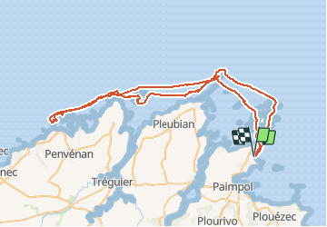
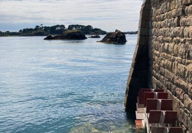
Trail Other activity of 75 km to be discovered at Brittany, Côtes-d'Armor, Ploubazlanec. This trail is proposed by tracegps.
Description
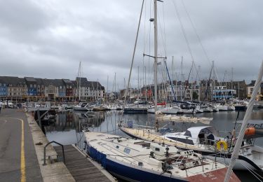
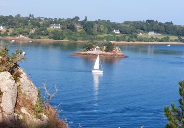
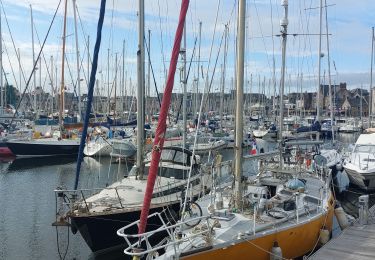
bonjour, Circuit très intéressant par la variété des paysages. Il nécessite un peu de condition physique pour tenir la distance et je dois dire que j'étais vanné à la fin de la première journée. PS: on a vu un phoque
Positioning
Country:
France
Region :
Brittany
Department/Province :
Côtes-d'Armor
Municipality :
Ploubazlanec
Location:
Unknown
Start:(Dec)
Start:(UTM)
498830 ; 5406265 (30U) N.
Comments
Trails nearby
![Trail Walking Île-de-Bréhat - Bréhat : le tour de l'ile - Photo](https://media.geolcdn.com/t/375/260/ext.jpg?maxdim=2&url=https%3A%2F%2Fservices.sitytrail.com%2FGeolivesWS%2FDownloadMedia.ashx%3FTrailID%3D105477%26Media%3D9220_6.jpg)
![Walking Walking](https://static1.geolcdn.com/sitytour/trail-icons/101.png)
Bréhat : le tour de l'ile
Walking
Medium
(6)
Île-de-Bréhat,
Brittany,
Côtes-d'Armor,
France
![](/images/other/stat-length.png)
11.9 km | 13.8 km-effort
5h 0min
![](https://static1.geolcdn.com/siteimages/upload/files/16400158638029165_repeat_loop_refresh_sync_direction_icon.png)
Yes
![Trail Walking Paimpol - Paimpol - GR34 Port Lazo - 25.5km 400m 6h15 (45mn) - 2024 06 30 - Photo](https://media.geolcdn.com/t/375/260/a1e8d6e5-d31d-477d-9229-268ec1b6062a.jpg&format=jpg&maxdim=2)
![Walking Walking](https://static1.geolcdn.com/sitytour/trail-icons/101.png)
Paimpol - GR34 Port Lazo - 25.5km 400m 6h15 (45mn) - 2024 06 30
Walking
Difficult
Paimpol,
Brittany,
Côtes-d'Armor,
France
![](/images/other/stat-length.png)
26 km | 31 km-effort
6h 15min
![](https://static1.geolcdn.com/siteimages/upload/files/16400158638029165_repeat_loop_refresh_sync_direction_icon.png)
Yes
![Trail Walking Ploubazlanec - Loguivy-de-la-Mer Mélus - GR34 Paimpol - 22.4km 375m 3h30 (45mn) - 2024 06 29 - Photo](https://media.geolcdn.com/t/375/260/448477d6-4d29-455f-a129-e2f273f0fc82.jpg&format=jpg&maxdim=2)
![Walking Walking](https://static1.geolcdn.com/sitytour/trail-icons/101.png)
Loguivy-de-la-Mer Mélus - GR34 Paimpol - 22.4km 375m 3h30 (45mn) - 2024 06 29
Walking
Medium
Ploubazlanec,
Brittany,
Côtes-d'Armor,
France
![](/images/other/stat-length.png)
22 km | 27 km-effort
5h 30min
![](https://static1.geolcdn.com/siteimages/upload/files/16400158638029165_repeat_loop_refresh_sync_direction_icon.png)
Yes
![Trail Walking Ploubazlanec - GR34-EtapeII-J04 - Photo](https://media.geolcdn.com/t/375/260/ext.jpg?maxdim=2&url=https%3A%2F%2Fstatic1.geolcdn.com%2Fsiteimages%2Fupload%2Ffiles%2F1553511878bg_sport_marche.png)
![Walking Walking](https://static1.geolcdn.com/sitytour/trail-icons/101.png)
GR34-EtapeII-J04
Walking
Medium
(1)
Ploubazlanec,
Brittany,
Côtes-d'Armor,
France
![](/images/other/stat-length.png)
23 km | 29 km-effort
8h 0min
![](https://static1.geolcdn.com/siteimages/upload/files/16400158638029165_repeat_loop_refresh_sync_direction_icon.png)
No
![Trail Walking Ploubazlanec - GR_34_DB_23_Ploubazlanec_Lezardrieux_20240804 - Photo](https://media.geolcdn.com/t/375/260/035eb0c7-4ec6-4759-a713-1d9f7c3da5e8.jpg&format=jpg&maxdim=2)
![Walking Walking](https://static1.geolcdn.com/sitytour/trail-icons/101.png)
GR_34_DB_23_Ploubazlanec_Lezardrieux_20240804
Walking
Medium
Ploubazlanec,
Brittany,
Côtes-d'Armor,
France
![](/images/other/stat-length.png)
10.5 km | 13.5 km-effort
2h 45min
![](https://static1.geolcdn.com/siteimages/upload/files/16400158638029165_repeat_loop_refresh_sync_direction_icon.png)
No
![Trail Walking Paimpol - GR_34_DA_22_Paimpol_Ploubaznalec_20240803 - Photo](https://media.geolcdn.com/t/375/260/0691f913-588d-481a-9b61-db0502f9b2fe.jpg&format=jpg&maxdim=2)
![Walking Walking](https://static1.geolcdn.com/sitytour/trail-icons/101.png)
GR_34_DA_22_Paimpol_Ploubaznalec_20240803
Walking
Easy
Paimpol,
Brittany,
Côtes-d'Armor,
France
![](/images/other/stat-length.png)
14.5 km | 17.9 km-effort
4h 4min
![](https://static1.geolcdn.com/siteimages/upload/files/16400158638029165_repeat_loop_refresh_sync_direction_icon.png)
No
![Trail Walking Île-de-Bréhat - Brehat - Photo](https://media.geolcdn.com/t/375/260/0a4d1679-23d9-4468-ab31-dae6a840aad9.jpg&format=jpg&maxdim=2)
![Walking Walking](https://static1.geolcdn.com/sitytour/trail-icons/101.png)
Brehat
Walking
Easy
Île-de-Bréhat,
Brittany,
Côtes-d'Armor,
France
![](/images/other/stat-length.png)
11.9 km | 13.9 km-effort
3h 50min
![](https://static1.geolcdn.com/siteimages/upload/files/16400158638029165_repeat_loop_refresh_sync_direction_icon.png)
No
![Trail Walking Île-de-Bréhat - Brèhat 12.7.23 - Photo](https://media.geolcdn.com/t/375/260/2124d513-107f-47ac-990f-7fff2269b965.jpg&format=jpg&maxdim=2)
![Walking Walking](https://static1.geolcdn.com/sitytour/trail-icons/101.png)
Brèhat 12.7.23
Walking
Easy
Île-de-Bréhat,
Brittany,
Côtes-d'Armor,
France
![](/images/other/stat-length.png)
16 km | 18.6 km-effort
4h 40min
![](https://static1.geolcdn.com/siteimages/upload/files/16400158638029165_repeat_loop_refresh_sync_direction_icon.png)
No
![Trail Walking Île-de-Bréhat - Île de Brehat - Photo](https://media.geolcdn.com/t/375/260/ca1635b8-25c4-427a-812d-df20b962ee35.jpg&format=jpg&maxdim=2)
![Walking Walking](https://static1.geolcdn.com/sitytour/trail-icons/101.png)
Île de Brehat
Walking
Easy
Île-de-Bréhat,
Brittany,
Côtes-d'Armor,
France
![](/images/other/stat-length.png)
15.4 km | 17.5 km-effort
4h 22min
![](https://static1.geolcdn.com/siteimages/upload/files/16400158638029165_repeat_loop_refresh_sync_direction_icon.png)
Yes