![](/images/other/stat-length.png)
![Trail Walking Marseille - Marseille - ND de la Garde - Corniche - Photo](https://media.geolcdn.com/t/1900/400/ext.pjpeg?maxdim=2&url=https%3A%2F%2Fservices.sitytrail.com%2FGeolivesWS%2FDownloadMedia.ashx%3FTrailID%3D103849%26Media%3D6643_1.jpg)
Marseille - ND de la Garde - Corniche
tracegps
User
![Length](/images/other/stat-length.png)
![Max alt](https://static1.geolcdn.com/siteimages/upload/files/1508320355ic_sort_altitude_max_24dp.png)
![Uphill gradient](https://static1.geolcdn.com/siteimages/upload/files/1508320355ic_sort_den_pos_24dp.png)
![Km-Effort](/images/other/stat-length.png)
![Min alt](https://static1.geolcdn.com/siteimages/upload/files/1508320355ic_sort_altitude_min_24dp.png)
![Downhill gradient](https://static1.geolcdn.com/siteimages/upload/files/1508320355ic_sort_den_neg_24dp.png)
![Boucle](https://static1.geolcdn.com/siteimages/upload/files/16400158638029165_repeat_loop_refresh_sync_direction_icon.png)
![Walking](https://static1.geolcdn.com/sitytour/trail-icons/101.png)
2h49
Difficulty : Medium
![Scan this QR Code to open this trail in the SityTrail application](https://capi.geolives.com/qq0zvz2zws4bq2lad0pu/sitytour/trails/103849/qr.png?size=200)
FREE GPS app for hiking
About
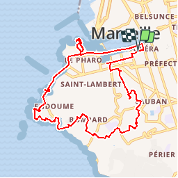
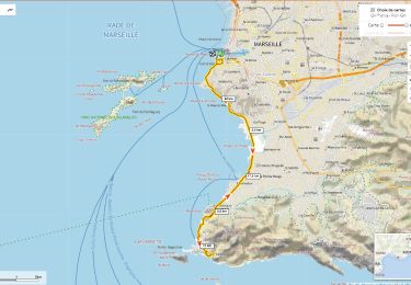
Trail Walking of 11.2 km to be discovered at Provence-Alpes-Côte d'Azur, Bouches-du-Rhône, Marseille. This trail is proposed by tracegps.
Description
Très belle randonnée pédestre en ville. Niveau de difficulté 3 à 4. (De nombreux escaliers). Vous pourrez vous garer au parking souterrain Estienne d'Orves au Vieux Port. Vous passerez ensuite à l'abbaye Saint Victor, devant le four des navettes, vous grimperez à Notre Dame de la Garde ou vous pourrez jouir d'un magnifique panorama; la suite se fera à travers des quartiers de Vauban, le Roucas Blanc et Bompart par des rues souvent en escalier. Vous pourrez vous arrêter au jardin de la Villa Valmer (magnifique point de vue sur l'archipel du Frioul). Vous descendrez ensuite sur la corniche pour atteindre l'anse de la Fausse Monaie, Malmousque, le Vallon des Auffes, les Catalans, le Pharo pour rejoindre ensuite le Vieux Port où vous terminerez cette randonnée. D’autres informations sur le site de Rando Loisirs à Carnoux en Provence.
Positioning
Comments
Trails nearby
![Trail Walking Marseille - Marseille complément visite 2023 - Photo](https://media.geolcdn.com/t/375/260/97d497f7-1fc4-4cf2-852e-2c51bf4faab1.jpg&format=jpg&maxdim=2)
![Walking Walking](https://static1.geolcdn.com/sitytour/trail-icons/101.png)
Walking
![](/images/other/stat-length.png)
![](https://static1.geolcdn.com/siteimages/upload/files/16400158638029165_repeat_loop_refresh_sync_direction_icon.png)
![Trail Walking Marseille - 2020-10-04_14h47m25_20201004_093926 Notre-Dame de la Garde - Photo](https://media.geolcdn.com/t/375/260/f7410e73-27c3-45bd-a02f-4730e681d2d2.jpeg&format=jpg&maxdim=2)
![Walking Walking](https://static1.geolcdn.com/sitytour/trail-icons/101.png)
Walking
![](/images/other/stat-length.png)
![](https://static1.geolcdn.com/siteimages/upload/files/16400158638029165_repeat_loop_refresh_sync_direction_icon.png)
![Walking Walking](https://static1.geolcdn.com/sitytour/trail-icons/101.png)
Walking
![](/images/other/stat-length.png)
![](https://static1.geolcdn.com/siteimages/upload/files/16400158638029165_repeat_loop_refresh_sync_direction_icon.png)
![Trail Mountain bike Marseille - OR-6270829--Marseille:Trilogie des Calanques - Photo](https://media.geolcdn.com/t/375/260/fd63da51-6807-4afd-affa-8748ae57a4c2.jpg&format=jpg&maxdim=2)
![Mountain bike Mountain bike](https://static1.geolcdn.com/sitytour/trail-icons/202.png)
Mountain bike
![](/images/other/stat-length.png)
![](https://static1.geolcdn.com/siteimages/upload/files/16400158638029165_repeat_loop_refresh_sync_direction_icon.png)
![Walking Walking](https://static1.geolcdn.com/sitytour/trail-icons/101.png)
Walking
![](/images/other/stat-length.png)
![](https://static1.geolcdn.com/siteimages/upload/files/16400158638029165_repeat_loop_refresh_sync_direction_icon.png)
![Trail Walking Marseille - Marseille Pharo-place aux huiles - Photo](https://media.geolcdn.com/t/375/260/93207b24-1cd8-4343-bf83-0df840e89c3d.jpg&format=jpg&maxdim=2)
![Walking Walking](https://static1.geolcdn.com/sitytour/trail-icons/101.png)
Walking
![](/images/other/stat-length.png)
![](https://static1.geolcdn.com/siteimages/upload/files/16400158638029165_repeat_loop_refresh_sync_direction_icon.png)
![Trail Walking Marseille - Marseille Catalans-les Auffes - Photo](https://media.geolcdn.com/t/375/260/1c14f901-9341-4453-9185-3d6b1430d102.jpg&format=jpg&maxdim=2)
![Walking Walking](https://static1.geolcdn.com/sitytour/trail-icons/101.png)
Walking
![](/images/other/stat-length.png)
![](https://static1.geolcdn.com/siteimages/upload/files/16400158638029165_repeat_loop_refresh_sync_direction_icon.png)
![Trail Walking Marseille - 20230829. Balade du matin - Photo](https://media.geolcdn.com/t/375/260/60ae8fd2-a6d5-49a7-af59-b13ebdcafa47.jpg&format=jpg&maxdim=2)
![Walking Walking](https://static1.geolcdn.com/sitytour/trail-icons/101.png)
Walking
![](/images/other/stat-length.png)
![](https://static1.geolcdn.com/siteimages/upload/files/16400158638029165_repeat_loop_refresh_sync_direction_icon.png)
![Road bike Road bike](https://static1.geolcdn.com/sitytour/trail-icons/201.png)
Road bike
![](/images/other/stat-length.png)
![](https://static1.geolcdn.com/siteimages/upload/files/16400158638029165_repeat_loop_refresh_sync_direction_icon.png)