Trail Cycle Rombas - Fil Bleu de l'Orne du Village d'Animations à Rombas à Moineville - Photo

Fil Bleu de l'Orne du Village d'Animations à Rombas à Moineville

© OpenStreetMap contributors
Length
Length
23 km
Max alt
Max alt
195 m
Uphill gradient
Uphill gradient
159 m
Km-Effort
Km-Effort  
25 km
Min alt
Min alt
162 m
Downhill gradient
Downhill gradient
142 m
Boucle
Boucle
No
Creation date :
2019-01-15 16:00:08.749
Updated on :
2019-01-15 16:00:08.749

(0 Reviews)

Cycle
Cycle
1h28
Difficulty : Easy

Scan this QR Code to open this trail in the SityTrail application

FREE GPS app for hiking

Logo SityTrail SityTrail

IGN / Geographical institutes

Download SityTrail from the App Store Download SityTrail from Google Play

Logo SityTrail SityTrail World

The world is yours!

Download SityTrail from the App Store Download SityTrail from Google Play Download SityTrail on Huawei AppGallery

About

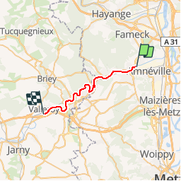
Trail Cycle of 23 km to be discovered at Grand Est, Moselle, Rombas. This trail is proposed by edmondnagel.

Description

Cette voie verte de 23 km longe la rivière Orne de Rombas en Moselle à la zone de loisirs de Moineville en Meurthe-et-Moselle. Cette piste est un moyen doux de découvrir les paysages d'une ancienne vallée sidérurgique. Entièrement plate et en site propre elle ravira les amateurs de vélo et de découverte, seul, en famille ou entre amis.

Elevation profile

Points of interest

Point of interest Jœuf - Joeuf - Photo
edmondnagel
JŒUF 
Point of interest Auboué - Auboué - Photo
edmondnagel
AUBOUÉ 
Point of interest Moyeuvre-Grande - Gare de Moyeuvre-Grande - Photo
edmondnagel
MOYEUVRE-GRANDE 
Point of interest Valleroy - Gare de Valleroy - Moineville - Photo
edmondnagel
Point of interest Rombas - Gare de Rombas - Clouange - Photo
edmondnagel

Positioning

Country:
France
Region :
Grand Est
Department/Province :
Moselle
Municipality :
Rombas
Location:
Unknown
Start:(Dec)
Start:(UTM)
289891 ; 5460669 (32U) N.

Trails nearby

Trail Mountain bike Rombas - Le petit huit en forêt entre Clouange, Ranguevaux et Fameck - Photo
Mountain bike
tracegps

Mountain bike

Medium
(2)
Rombas, Grand Est, Moselle, France
29 km | 38 km-effort
1h 30min
Yes
Trail On foot Rombas - Circuit de Rombas - Photo
On foot
GUIDE+

On foot

Easy
Rombas, Grand Est, Moselle, France
7.8 km | 10.5 km-effort
2h 23min
Yes
Trail Walking Rombas - ROMBAS - ROMBAS ET LA CÔTE DE DRINCE - Photo
Walking
jean-marie.parachini

Walking

Difficult
Rombas, Grand Est, Moselle, France
18.6 km | 27 km-effort
9h 59min
Yes
Trail Walking Rombas - Rombas Etang de Rombas et Côte de Drince - Photo
Walking
jean-marie.parachini

Walking

Difficult
Rombas, Grand Est, Moselle, France
17.8 km | 26 km-effort
10h 10min
Yes
Trail Walking Rombas - Rombas Tour de Drince - Photo
Walking
patrick57

Walking

Very easy
(1)
Rombas, Grand Est, Moselle, France
10 km | 14.4 km-effort
3h 0min
Yes
Trail On foot Pierrevillers - Approche d'un Sentier de GR - Photo
On foot
GUIDE+

On foot

Easy
Pierrevillers, Grand Est, Moselle, France
3.4 km | 5 km-effort
1h 8min
No
Trail On foot Rombas - Circuit de la Côte de Drince - Photo
On foot
GUIDE+

On foot

Easy
Rombas, Grand Est, Moselle, France
5.7 km | 8.6 km-effort
1h 57min
No
Trail Other activity Gandrange - VTT tour de Drince - Photo
Other activity
SylvainSCG

Other activity

Difficult
Gandrange, Grand Est, Moselle, France
32 km | 41 km-effort
3h 8min
Yes
Trail Other activity Rombas - après-midi geocaching - Photo
Other activity
lolokam

Other activity

Easy
Rombas, Grand Est, Moselle, France
8.7 km | 12.2 km-effort
3h 5min
Yes


Close
My subscriptions