![](/images/other/stat-length.png)
![Trail Walking Le Mayet-de-Montagne - Saint Clément - Photo](https://media.geolcdn.com/t/1900/400/ext.pjpeg?maxdim=2&url=https%3A%2F%2Fservices.sitytrail.com%2FGeolivesWS%2FDownloadMedia.ashx%3FTrailID%3D103644%26Media%3D6073_3.jpg)
Saint Clément
tracegps
User
![Length](/images/other/stat-length.png)
Length
15.9 km
![Max alt](https://static1.geolcdn.com/siteimages/upload/files/1508320355ic_sort_altitude_max_24dp.png)
Max alt
760 m
![Uphill gradient](https://static1.geolcdn.com/siteimages/upload/files/1508320355ic_sort_den_pos_24dp.png)
Uphill gradient
536 m
![Km-Effort](/images/other/stat-length.png)
Km-Effort
23 km
![Min alt](https://static1.geolcdn.com/siteimages/upload/files/1508320355ic_sort_altitude_min_24dp.png)
Min alt
453 m
![Downhill gradient](https://static1.geolcdn.com/siteimages/upload/files/1508320355ic_sort_den_neg_24dp.png)
Downhill gradient
538 m
![Boucle](https://static1.geolcdn.com/siteimages/upload/files/16400158638029165_repeat_loop_refresh_sync_direction_icon.png)
Boucle
Yes
Creation date :
2014-12-10 00:00:00.0
Updated on :
2014-12-10 00:00:00.0
![Walking](https://static1.geolcdn.com/sitytour/trail-icons/101.png)
3h30
Difficulty : Difficult
![Scan this QR Code to open this trail in the SityTrail application](https://capi.geolives.com/qq0zvz2zws4bq2lad0pu/sitytour/trails/103644/qr.png?size=200)
FREE GPS app for hiking
About
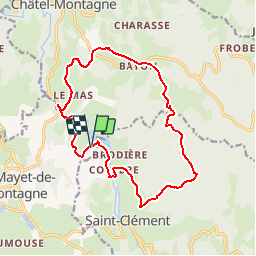
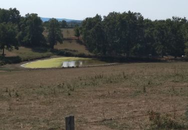
Trail Walking of 15.9 km to be discovered at Auvergne-Rhône-Alpes, Allier, Le Mayet-de-Montagne. This trail is proposed by tracegps.
Description
Départ du plan d'eau de Saint Clément. Attention la descente depuis la croix de Mondolin est piégeuse. Passage devant le centre de l'Europe des 12, un vieux souvenir!!! Au plan d'eau, diverses activités suivre le lien Plan d'Eau de St Clément.
Positioning
Country:
France
Region :
Auvergne-Rhône-Alpes
Department/Province :
Allier
Municipality :
Le Mayet-de-Montagne
Location:
Unknown
Start:(Dec)
Start:(UTM)
553532 ; 5103077 (31T) N.
Comments
Trails nearby
![Trail Running Châtel-Montagne - jour 7 CAP Jeanot - Photo](https://media.geolcdn.com/t/375/260/8a698184-4193-4775-82fc-8cbe0040237c.jpg&format=jpg&maxdim=2)
![Running Running](https://static1.geolcdn.com/sitytour/trail-icons/103.png)
jour 7 CAP Jeanot
Running
Very easy
Châtel-Montagne,
Auvergne-Rhône-Alpes,
Allier,
France
![](/images/other/stat-length.png)
33 km | 43 km-effort
4h 29min
![](https://static1.geolcdn.com/siteimages/upload/files/16400158638029165_repeat_loop_refresh_sync_direction_icon.png)
No
![Trail Walking Châtel-Montagne - Le Puy du Roc - Châtel-Montagne - Photo](https://media.geolcdn.com/t/375/260/ext.jpg?maxdim=2&url=https%3A%2F%2Fservices.sitytrail.com%2FGeolivesWS%2FDownloadMedia.ashx%3FTrailID%3D173073%26Media%3D14605_6.jpg)
![Walking Walking](https://static1.geolcdn.com/sitytour/trail-icons/101.png)
Le Puy du Roc - Châtel-Montagne
Walking
Medium
Châtel-Montagne,
Auvergne-Rhône-Alpes,
Allier,
France
![](/images/other/stat-length.png)
10.2 km | 15.3 km-effort
3h 0min
![](https://static1.geolcdn.com/siteimages/upload/files/16400158638029165_repeat_loop_refresh_sync_direction_icon.png)
Yes
![Trail Hybrid bike Châtel-Montagne - jour 7 - Photo](https://media.geolcdn.com/t/375/260/e89c6336-8612-483e-aed3-1c25fc42c2f5.jpg&format=jpg&maxdim=2)
![Hybrid bike Hybrid bike](https://static1.geolcdn.com/sitytour/trail-icons/203.png)
jour 7
Hybrid bike
Very easy
Châtel-Montagne,
Auvergne-Rhône-Alpes,
Allier,
France
![](/images/other/stat-length.png)
27 km | 32 km-effort
2h 6min
![](https://static1.geolcdn.com/siteimages/upload/files/16400158638029165_repeat_loop_refresh_sync_direction_icon.png)
No
![Trail Walking Châtel-Montagne - Balade autour du Mont Aigu - Le Moulin Chatel - Photo](https://media.geolcdn.com/t/375/260/ext.jpg?maxdim=2&url=https%3A%2F%2Fservices.sitytrail.com%2FGeolivesWS%2FDownloadMedia.ashx%3FTrailID%3D191451%26Media%3D15040_2.jpg)
![Walking Walking](https://static1.geolcdn.com/sitytour/trail-icons/101.png)
Balade autour du Mont Aigu - Le Moulin Chatel
Walking
Medium
Châtel-Montagne,
Auvergne-Rhône-Alpes,
Allier,
France
![](/images/other/stat-length.png)
10.4 km | 14.1 km-effort
2h 30min
![](https://static1.geolcdn.com/siteimages/upload/files/16400158638029165_repeat_loop_refresh_sync_direction_icon.png)
Yes
![Trail Walking Le Mayet-de-Montagne - Le Grand Roc - Le Mallot - Photo](https://media.geolcdn.com/t/375/260/ext.jpg?maxdim=2&url=https%3A%2F%2Fservices.sitytrail.com%2FGeolivesWS%2FDownloadMedia.ashx%3FTrailID%3D173257%26Media%3D14872_1.jpg)
![Walking Walking](https://static1.geolcdn.com/sitytour/trail-icons/101.png)
Le Grand Roc - Le Mallot
Walking
Medium
Le Mayet-de-Montagne,
Auvergne-Rhône-Alpes,
Allier,
France
![](/images/other/stat-length.png)
10.4 km | 15.2 km-effort
2h 45min
![](https://static1.geolcdn.com/siteimages/upload/files/16400158638029165_repeat_loop_refresh_sync_direction_icon.png)
Yes
![Trail Equestrian Saint-Clément - 2024-06-16_20h48m09_st-clement-03250 - Photo](https://media.geolcdn.com/t/375/260/ext.jpg?maxdim=2&url=https%3A%2F%2Fstatic1.geolcdn.com%2Fsiteimages%2Fupload%2Ffiles%2F1524743154cheval.jpg)
![Equestrian Equestrian](https://static1.geolcdn.com/sitytour/trail-icons/300.png)
2024-06-16_20h48m09_st-clement-03250
Equestrian
Medium
Saint-Clément,
Auvergne-Rhône-Alpes,
Allier,
France
![](/images/other/stat-length.png)
30 km | 42 km-effort
Unknown
![](https://static1.geolcdn.com/siteimages/upload/files/16400158638029165_repeat_loop_refresh_sync_direction_icon.png)
Yes
![Trail Equestrian Saint-Clément - 2024-06-16_20h47m36_Chatel_montagne (1) - Photo](https://media.geolcdn.com/t/375/260/ext.jpg?maxdim=2&url=https%3A%2F%2Fstatic1.geolcdn.com%2Fsiteimages%2Fupload%2Ffiles%2F1524743154cheval.jpg)
![Equestrian Equestrian](https://static1.geolcdn.com/sitytour/trail-icons/300.png)
2024-06-16_20h47m36_Chatel_montagne (1)
Equestrian
Medium
Saint-Clément,
Auvergne-Rhône-Alpes,
Allier,
France
![](/images/other/stat-length.png)
25 km | 35 km-effort
Unknown
![](https://static1.geolcdn.com/siteimages/upload/files/16400158638029165_repeat_loop_refresh_sync_direction_icon.png)
Yes
![Trail Horseback riding Le Mayet-de-Montagne - saint clement 03250 30 kms - Photo](https://media.geolcdn.com/t/375/260/ext.jpg?maxdim=2&url=https%3A%2F%2Fstatic1.geolcdn.com%2Fsiteimages%2Fupload%2Ffiles%2F1524743154cheval.jpg)
![Horseback riding Horseback riding](https://static1.geolcdn.com/sitytour/trail-icons/301.png)
saint clement 03250 30 kms
Horseback riding
Difficult
Le Mayet-de-Montagne,
Auvergne-Rhône-Alpes,
Allier,
France
![](/images/other/stat-length.png)
28 km | 39 km-effort
7h 34min
![](https://static1.geolcdn.com/siteimages/upload/files/16400158638029165_repeat_loop_refresh_sync_direction_icon.png)
No
![Trail Walking Châtel-Montagne - Chatel Montagne - centrale hydroelectrique - Photo](https://media.geolcdn.com/t/375/260/ext.jpg?maxdim=2&url=https%3A%2F%2Fservices.sitytrail.com%2FGeolivesWS%2FDownloadMedia.ashx%3FTrailID%3D595718%26Media%3Db3cd818e-6b88-44c4-afd8-54f2af56cebf.jpg)
![Walking Walking](https://static1.geolcdn.com/sitytour/trail-icons/101.png)
Chatel Montagne - centrale hydroelectrique
Walking
Easy
Châtel-Montagne,
Auvergne-Rhône-Alpes,
Allier,
France
![](/images/other/stat-length.png)
11.9 km | 17.1 km-effort
3h 40min
![](https://static1.geolcdn.com/siteimages/upload/files/16400158638029165_repeat_loop_refresh_sync_direction_icon.png)
Yes