![](/images/other/stat-length.png)
![Trail Mountain bike Arsague - Entre Chalosse et béarn - Photo](https://media.geolcdn.com/t/1900/400/ext.pjpeg?maxdim=2&url=https%3A%2F%2Fstatic1.geolcdn.com%2Fsiteimages%2Fupload%2Ffiles%2F1524743154velo.jpg)
Entre Chalosse et béarn
tracegps
User
![Length](/images/other/stat-length.png)
Length
31 km
![Max alt](https://static1.geolcdn.com/siteimages/upload/files/1508320355ic_sort_altitude_max_24dp.png)
Max alt
177 m
![Uphill gradient](https://static1.geolcdn.com/siteimages/upload/files/1508320355ic_sort_den_pos_24dp.png)
Uphill gradient
562 m
![Km-Effort](/images/other/stat-length.png)
Km-Effort
38 km
![Min alt](https://static1.geolcdn.com/siteimages/upload/files/1508320355ic_sort_altitude_min_24dp.png)
Min alt
75 m
![Downhill gradient](https://static1.geolcdn.com/siteimages/upload/files/1508320355ic_sort_den_neg_24dp.png)
Downhill gradient
562 m
![Boucle](https://static1.geolcdn.com/siteimages/upload/files/16400158638029165_repeat_loop_refresh_sync_direction_icon.png)
Boucle
Yes
Creation date :
2014-12-10 00:00:00.0
Updated on :
2014-12-10 00:00:00.0
![Mountain bike](https://static1.geolcdn.com/sitytour/trail-icons/202.png)
2h15
Difficulty : Difficult
![Scan this QR Code to open this trail in the SityTrail application](https://capi.geolives.com/qq0zvz2zws4bq2lad0pu/sitytour/trails/103638/qr.png?size=200)
FREE GPS app for hiking
About
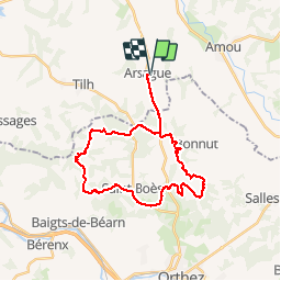
Trail Mountain bike of 31 km to be discovered at New Aquitaine, Landes, Arsague. This trail is proposed by tracegps.
Description
Circuit roulant dans les bois et chemin de remembrement, comprenant environ 490m d'ascension totale. Chemin praticable par temps sec. Stationnement possible sur la place en face de la salle de sport.
Positioning
Country:
France
Region :
New Aquitaine
Department/Province :
Landes
Municipality :
Arsague
Location:
Unknown
Start:(Dec)
Start:(UTM)
678164 ; 4827553 (30T) N.
Comments
Trails nearby
![Trail On foot Saint-Girons-en-Béarn - 51-La pignada - Photo](https://media.geolcdn.com/t/375/260/ext.jpg?maxdim=2&url=https%3A%2F%2Fstatic1.geolcdn.com%2Fsiteimages%2Fupload%2Ffiles%2F1545311037marcheuse_200dpi.jpg)
![On foot On foot](https://static1.geolcdn.com/sitytour/trail-icons/100.png)
51-La pignada
On foot
Very easy
Saint-Girons-en-Béarn,
New Aquitaine,
Pyrénées-Atlantiques,
France
![](/images/other/stat-length.png)
9.4 km | 12.2 km-effort
Unknown
![](https://static1.geolcdn.com/siteimages/upload/files/16400158638029165_repeat_loop_refresh_sync_direction_icon.png)
Yes
![Trail Walking Saint-Girons-en-Béarn - saint girons fait - Photo](https://media.geolcdn.com/t/375/260/ext.jpg?maxdim=2&url=https%3A%2F%2Fstatic1.geolcdn.com%2Fsiteimages%2Fupload%2Ffiles%2F1553511878bg_sport_marche.png)
![Walking Walking](https://static1.geolcdn.com/sitytour/trail-icons/101.png)
saint girons fait
Walking
Very easy
Saint-Girons-en-Béarn,
New Aquitaine,
Pyrénées-Atlantiques,
France
![](/images/other/stat-length.png)
9.9 km | 12.7 km-effort
3h 46min
![](https://static1.geolcdn.com/siteimages/upload/files/16400158638029165_repeat_loop_refresh_sync_direction_icon.png)
Yes
![Trail Walking Saint-Girons-en-Béarn - 2019-11-18_22h31m06_51-La-pignada - Photo](https://media.geolcdn.com/t/375/260/ext.jpg?maxdim=2&url=https%3A%2F%2Fstatic1.geolcdn.com%2Fsiteimages%2Fupload%2Ffiles%2F1553511878bg_sport_marche.png)
![Walking Walking](https://static1.geolcdn.com/sitytour/trail-icons/101.png)
2019-11-18_22h31m06_51-La-pignada
Walking
Medium
Saint-Girons-en-Béarn,
New Aquitaine,
Pyrénées-Atlantiques,
France
![](/images/other/stat-length.png)
9.4 km | 12.2 km-effort
2h 36min
![](https://static1.geolcdn.com/siteimages/upload/files/16400158638029165_repeat_loop_refresh_sync_direction_icon.png)
Yes