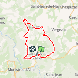
![](/images/other/stat-length.png)
![Trail Mountain bike Saint-Privat-d'Allier - St Privat à Durande - Photo](https://media.geolcdn.com/t/1900/400/ext.pjpeg?maxdim=2&url=https%3A%2F%2Fstatic1.geolcdn.com%2Fsiteimages%2Fupload%2Ffiles%2F1524743154velo.jpg)
St Privat à Durande
tracegps
User
![Length](/images/other/stat-length.png)
![Max alt](https://static1.geolcdn.com/siteimages/upload/files/1508320355ic_sort_altitude_max_24dp.png)
![Uphill gradient](https://static1.geolcdn.com/siteimages/upload/files/1508320355ic_sort_den_pos_24dp.png)
![Km-Effort](/images/other/stat-length.png)
![Min alt](https://static1.geolcdn.com/siteimages/upload/files/1508320355ic_sort_altitude_min_24dp.png)
![Downhill gradient](https://static1.geolcdn.com/siteimages/upload/files/1508320355ic_sort_den_neg_24dp.png)
![Boucle](https://static1.geolcdn.com/siteimages/upload/files/16400158638029165_repeat_loop_refresh_sync_direction_icon.png)
![Mountain bike](https://static1.geolcdn.com/sitytour/trail-icons/202.png)
3h00
Difficulty : Difficult
![Scan this QR Code to open this trail in the SityTrail application](https://capi.geolives.com/qq0zvz2zws4bq2lad0pu/sitytour/trails/103619/qr.png?size=200)
FREE GPS app for hiking
About
Trail Mountain bike of 27 km to be discovered at Auvergne-Rhône-Alpes, Haute-Loire, Saint-Privat-d'Allier. This trail is proposed by tracegps.
Description
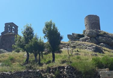
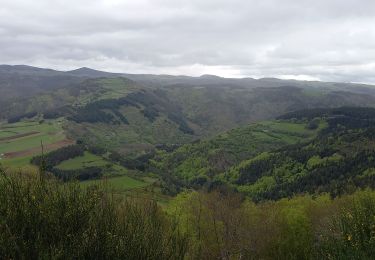
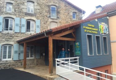
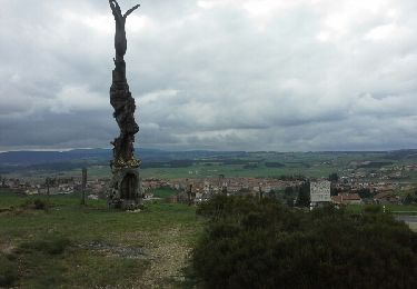
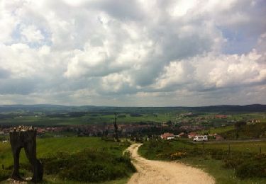
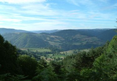
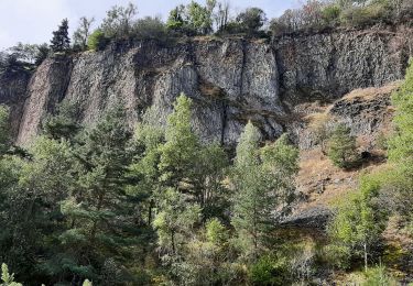
Un circuit en boucle fermée partant de Saint Privat d’Allier à la Durande. Il commence par le chemin de Saint Jacques de Compostelle jusqu’à Rochegude. Avec ses tours et son église perchés sur un rocher, le site est classé monument historique. Une vue splendide sur les gorges de l’Allier. On voit aussi le chemin de fer longeant l’Allier qui est le seul moyen d’accès aux gorges de l’Allier sans se mouiller. Le circuit mène ensuite vers le sommet de La Durande. Vous avez une vue panoramique au sommet sur le massif d’Auvergne et on peut se référer à la table d’orientation. Le circuit passe ensuite par le Vernet, avec les jeux pour les enfants et un parcours sportif. On continue par une partie de ce circuit puis on se dirige vers le Merceur. Ce village est bien connu pour son château. On continu ensuite par Le Villard puis Le Chier où on reprend le chemin de Saint Jacques de Compostelle jusqu’à St Privat d’Allier.
Points of interest
Positioning
Comments
Trails nearby
![Trail Walking Saint-Privat-d'Allier - lac de l'oeuf / St Privat/ chapelle de Rochegude - Photo](https://media.geolcdn.com/t/375/260/9d549320-6680-4806-9ebd-0814248a01b9.jpg&format=jpg&maxdim=2)
![Walking Walking](https://static1.geolcdn.com/sitytour/trail-icons/101.png)
Walking
![](/images/other/stat-length.png)
![](https://static1.geolcdn.com/siteimages/upload/files/16400158638029165_repeat_loop_refresh_sync_direction_icon.png)
![Trail Walking Saint-Privat-d'Allier - le chier mont Devès - Photo](https://media.geolcdn.com/t/375/260/ext.jpg?maxdim=2&url=https%3A%2F%2Fstatic1.geolcdn.com%2Fsiteimages%2Fupload%2Ffiles%2F1553511878bg_sport_marche.png)
![Walking Walking](https://static1.geolcdn.com/sitytour/trail-icons/101.png)
Walking
![](/images/other/stat-length.png)
![](https://static1.geolcdn.com/siteimages/upload/files/16400158638029165_repeat_loop_refresh_sync_direction_icon.png)
![Trail Walking Monistrol-d'Allier - Monistrol/ Pourcheresse par le GR 470 - Photo](https://media.geolcdn.com/t/375/260/ab7973e1-5cd8-4724-a2d0-66e6171a4702.jpg&format=jpg&maxdim=2)
![Walking Walking](https://static1.geolcdn.com/sitytour/trail-icons/101.png)
Walking
![](/images/other/stat-length.png)
![](https://static1.geolcdn.com/siteimages/upload/files/16400158638029165_repeat_loop_refresh_sync_direction_icon.png)
![Walking Walking](https://static1.geolcdn.com/sitytour/trail-icons/101.png)
Walking
![](/images/other/stat-length.png)
![](https://static1.geolcdn.com/siteimages/upload/files/16400158638029165_repeat_loop_refresh_sync_direction_icon.png)
![Trail Walking Bains - Montbonnet - Saugues - Photo](https://media.geolcdn.com/t/375/260/ext.jpg?maxdim=2&url=https%3A%2F%2Fservices.sitytrail.com%2FGeolivesWS%2FDownloadMedia.ashx%3FTrailID%3D473813%26Media%3D20150919182921.jpg)
![Walking Walking](https://static1.geolcdn.com/sitytour/trail-icons/101.png)
Walking
![](/images/other/stat-length.png)
![](https://static1.geolcdn.com/siteimages/upload/files/16400158638029165_repeat_loop_refresh_sync_direction_icon.png)
![Trail Walking Saint-Privat-d'Allier - saint Privat d'Allier - Saugues - Photo](https://media.geolcdn.com/t/375/260/ext.jpg?maxdim=2&url=https%3A%2F%2Fservices.sitytrail.com%2FGeolivesWS%2FDownloadMedia.ashx%3FTrailID%3D409514%26Media%3Dfix__20150418165122.jpg)
![Walking Walking](https://static1.geolcdn.com/sitytour/trail-icons/101.png)
Walking
![](/images/other/stat-length.png)
![](https://static1.geolcdn.com/siteimages/upload/files/16400158638029165_repeat_loop_refresh_sync_direction_icon.png)
![Trail Walking Monistrol-d'Allier - monistrol saugues - Photo](https://media.geolcdn.com/t/375/260/ext.jpg?maxdim=2&url=https%3A%2F%2Fservices.sitytrail.com%2FGeolivesWS%2FDownloadMedia.ashx%3FTrailID%3D131322%26Media%3D20120531150900.jpg)
![Walking Walking](https://static1.geolcdn.com/sitytour/trail-icons/101.png)
Walking
![](/images/other/stat-length.png)
![](https://static1.geolcdn.com/siteimages/upload/files/16400158638029165_repeat_loop_refresh_sync_direction_icon.png)
![Trail Walking Saint-Privat-d'Allier - St Privat d'Allier - Saugues - Chemin de Compostelle - Photo](https://media.geolcdn.com/t/375/260/ext.jpg?maxdim=2&url=https%3A%2F%2Fservices.sitytrail.com%2FGeolivesWS%2FDownloadMedia.ashx%3FTrailID%3D108146%26Media%3D199_1.jpg)
![Walking Walking](https://static1.geolcdn.com/sitytour/trail-icons/101.png)
Walking
![](/images/other/stat-length.png)
![](https://static1.geolcdn.com/siteimages/upload/files/16400158638029165_repeat_loop_refresh_sync_direction_icon.png)
![Trail Walking Monistrol-d'Allier - Monistrole-d'Allier - Photo](https://media.geolcdn.com/t/375/260/6d5464d8-d5dc-4cf4-a65e-1b4a38330085.jpg&format=jpg&maxdim=2)
![Walking Walking](https://static1.geolcdn.com/sitytour/trail-icons/101.png)
Walking
![](/images/other/stat-length.png)
![](https://static1.geolcdn.com/siteimages/upload/files/16400158638029165_repeat_loop_refresh_sync_direction_icon.png)