![](/images/other/stat-length.png)
![Trail Walking Arronnes - La Chapelle - Photo](https://media.geolcdn.com/t/1900/400/ext.pjpeg?maxdim=2&url=https%3A%2F%2Fstatic1.geolcdn.com%2Fsiteimages%2Fupload%2Ffiles%2F1553511878bg_sport_marche.png)
La Chapelle
tracegps
User
![Length](/images/other/stat-length.png)
Length
13.1 km
![Max alt](https://static1.geolcdn.com/siteimages/upload/files/1508320355ic_sort_altitude_max_24dp.png)
Max alt
595 m
![Uphill gradient](https://static1.geolcdn.com/siteimages/upload/files/1508320355ic_sort_den_pos_24dp.png)
Uphill gradient
320 m
![Km-Effort](/images/other/stat-length.png)
Km-Effort
17.4 km
![Min alt](https://static1.geolcdn.com/siteimages/upload/files/1508320355ic_sort_altitude_min_24dp.png)
Min alt
380 m
![Downhill gradient](https://static1.geolcdn.com/siteimages/upload/files/1508320355ic_sort_den_neg_24dp.png)
Downhill gradient
322 m
![Boucle](https://static1.geolcdn.com/siteimages/upload/files/16400158638029165_repeat_loop_refresh_sync_direction_icon.png)
Boucle
Yes
Creation date :
2014-12-10 00:00:00.0
Updated on :
2014-12-10 00:00:00.0
![Walking](https://static1.geolcdn.com/sitytour/trail-icons/101.png)
3h00
Difficulty : Difficult
![Scan this QR Code to open this trail in the SityTrail application](https://capi.geolives.com/qq0zvz2zws4bq2lad0pu/sitytour/trails/103578/qr.png?size=200)
FREE GPS app for hiking
About
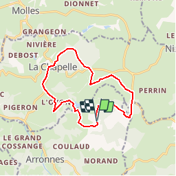
Trail Walking of 13.1 km to be discovered at Auvergne-Rhône-Alpes, Allier, Arronnes. This trail is proposed by tracegps.
Description
Dénivelé 305m. Départ de l'église de La Chapelle.Suivre le balisage jaune de PR jusqu'à l'intersection avant "le Faugeat" Circuit assez ombragé, peut se faire par temps chaud
Positioning
Country:
France
Region :
Auvergne-Rhône-Alpes
Department/Province :
Allier
Municipality :
Arronnes
Location:
Unknown
Start:(Dec)
Start:(UTM)
545946 ; 5102300 (31T) N.
Comments
Trails nearby
![Trail Other activity Arronnes - GC Mayet Ferrière - Photo](https://media.geolcdn.com/t/375/260/ext.jpg?maxdim=2&url=https%3A%2F%2Fservices.sitytrail.com%2FGeolivesWS%2FDownloadMedia.ashx%3FTrailID%3D176637%26Media%3Dfa7faa2a-0934-48f6-9bd7-2ad505607f45.gif)
![Other activity Other activity](https://static1.geolcdn.com/sitytour/trail-icons/900.png)
GC Mayet Ferrière
Other activity
Very easy
(1)
Arronnes,
Auvergne-Rhône-Alpes,
Allier,
France
![](/images/other/stat-length.png)
27 km | 34 km-effort
5min
![](https://static1.geolcdn.com/siteimages/upload/files/16400158638029165_repeat_loop_refresh_sync_direction_icon.png)
No
![Trail Walking Le Mayet-de-Montagne - Boucle autour du Cluzel - Arronnes - Photo](https://media.geolcdn.com/t/375/260/ext.jpg?maxdim=2&url=https%3A%2F%2Fservices.sitytrail.com%2FGeolivesWS%2FDownloadMedia.ashx%3FTrailID%3D118775%26Media%3D12975_1.jpg)
![Walking Walking](https://static1.geolcdn.com/sitytour/trail-icons/101.png)
Boucle autour du Cluzel - Arronnes
Walking
Medium
Le Mayet-de-Montagne,
Auvergne-Rhône-Alpes,
Allier,
France
![](/images/other/stat-length.png)
12 km | 15.8 km-effort
2h 45min
![](https://static1.geolcdn.com/siteimages/upload/files/16400158638029165_repeat_loop_refresh_sync_direction_icon.png)
Yes
![Trail Quad Ferrières-sur-Sichon - rando - Photo](https://media.geolcdn.com/t/375/260/ext.jpg?maxdim=2&url=https%3A%2F%2Fstatic1.geolcdn.com%2Fsiteimages%2Fupload%2Ffiles%2F15247431544x4.jpg)
![Quad Quad](https://static1.geolcdn.com/sitytour/trail-icons/404.png)
rando
Quad
Very easy
Ferrières-sur-Sichon,
Auvergne-Rhône-Alpes,
Allier,
France
![](/images/other/stat-length.png)
72 km | 103 km-effort
5h 17min
![](https://static1.geolcdn.com/siteimages/upload/files/16400158638029165_repeat_loop_refresh_sync_direction_icon.png)
Yes
![Trail Walking Arronnes - Balade sur Arronnes - Photo](https://media.geolcdn.com/t/375/260/ext.jpg?maxdim=2&url=https%3A%2F%2Fstatic1.geolcdn.com%2Fsiteimages%2Fupload%2Ffiles%2F1553511878bg_sport_marche.png)
![Walking Walking](https://static1.geolcdn.com/sitytour/trail-icons/101.png)
Balade sur Arronnes
Walking
Medium
Arronnes,
Auvergne-Rhône-Alpes,
Allier,
France
![](/images/other/stat-length.png)
16.3 km | 23 km-effort
4h 52min
![](https://static1.geolcdn.com/siteimages/upload/files/16400158638029165_repeat_loop_refresh_sync_direction_icon.png)
Yes
![Trail Cycle Arronnes - Gc Royére - Photo](https://media.geolcdn.com/t/375/260/ext.jpg?maxdim=2&url=https%3A%2F%2Fstatic1.geolcdn.com%2Fsiteimages%2Fupload%2Ffiles%2F1524743154velo.jpg)
![Cycle Cycle](https://static1.geolcdn.com/sitytour/trail-icons/200.png)
Gc Royére
Cycle
Medium
Arronnes,
Auvergne-Rhône-Alpes,
Allier,
France
![](/images/other/stat-length.png)
166 km | 204 km-effort
11h 40min
![](https://static1.geolcdn.com/siteimages/upload/files/16400158638029165_repeat_loop_refresh_sync_direction_icon.png)
No
![Trail Walking Nizerolles - Balade autour de Nizerolles - Photo](https://media.geolcdn.com/t/375/260/ext.jpg?maxdim=2&url=https%3A%2F%2Fstatic1.geolcdn.com%2Fsiteimages%2Fupload%2Ffiles%2F1553511878bg_sport_marche.png)
![Walking Walking](https://static1.geolcdn.com/sitytour/trail-icons/101.png)
Balade autour de Nizerolles
Walking
Medium
Nizerolles,
Auvergne-Rhône-Alpes,
Allier,
France
![](/images/other/stat-length.png)
9.7 km | 13.6 km-effort
2h 30min
![](https://static1.geolcdn.com/siteimages/upload/files/16400158638029165_repeat_loop_refresh_sync_direction_icon.png)
Yes
![Trail Walking Nizerolles - La Fontaine du Lion - Photo](https://media.geolcdn.com/t/375/260/ext.jpg?maxdim=2&url=https%3A%2F%2Fstatic1.geolcdn.com%2Fsiteimages%2Fupload%2Ffiles%2F1553511878bg_sport_marche.png)
![Walking Walking](https://static1.geolcdn.com/sitytour/trail-icons/101.png)
La Fontaine du Lion
Walking
Difficult
Nizerolles,
Auvergne-Rhône-Alpes,
Allier,
France
![](/images/other/stat-length.png)
12.4 km | 17.7 km-effort
3h 0min
![](https://static1.geolcdn.com/siteimages/upload/files/16400158638029165_repeat_loop_refresh_sync_direction_icon.png)
Yes
![Trail Quad La Chapelle - rando 3 du 19 - Photo](https://media.geolcdn.com/t/375/260/ext.jpg?maxdim=2&url=https%3A%2F%2Fstatic1.geolcdn.com%2Fsiteimages%2Fupload%2Ffiles%2F15247431544x4.jpg)
![Quad Quad](https://static1.geolcdn.com/sitytour/trail-icons/404.png)
rando 3 du 19
Quad
Very easy
La Chapelle,
Auvergne-Rhône-Alpes,
Allier,
France
![](/images/other/stat-length.png)
36 km | 47 km-effort
3h 37min
![](https://static1.geolcdn.com/siteimages/upload/files/16400158638029165_repeat_loop_refresh_sync_direction_icon.png)
No
![Trail Mountain bike Arronnes - doyat - Photo](https://media.geolcdn.com/t/375/260/ext.jpg?maxdim=2&url=https%3A%2F%2Fstatic1.geolcdn.com%2Fsiteimages%2Fupload%2Ffiles%2F1524743154velo.jpg)
![Mountain bike Mountain bike](https://static1.geolcdn.com/sitytour/trail-icons/202.png)
doyat
Mountain bike
Very difficult
Arronnes,
Auvergne-Rhône-Alpes,
Allier,
France
![](/images/other/stat-length.png)
37 km | 52 km-effort
3h 54min
![](https://static1.geolcdn.com/siteimages/upload/files/16400158638029165_repeat_loop_refresh_sync_direction_icon.png)
Yes